How to Explore Crater Lake National Park

Oregon is known for many great landscapes from its magnificent coast to the Cascade Mountains, to the Willamette Valley, to the Columbia River Gorge, etc. But one of its most spectacular sights has to be Crater Lake.

Crater Lake, since 1902 part of Crater Lake National Park, serves as witness to the incredible story of earth’s forces at work. Mount Mazama, the original volcano on that site, blew up about 7,700 years ago. The top of the volcano collapsed inward after all the contents spewed out (non-technical terms!) and created a caldera that has filled up with water since then from rain and snow melt.

Crater Lake, Mount Scott, hiking Crater Lake, Oregon, outdoors, nature. exploring Oregon
View towards the west from Mt. Scott

The lake is between 4.5-6 miles across and about 1,943 ft deep. It is considered the deepest lake in North America. And another bit of trivia: it holds almost 5 TRILLION gallons of water. Lots of H2O.

Though no streams flow out of this lake, the water level remains fairly constant because water does seep out or gets absorbed. The water has very little in terms of sediment flowing in (again, no streams feeding it) which helps give it its unique color. It is an intense, beautiful, entrancing blue.

Do the Crater Lake rim drive!

Today, one can drive all around the rim of the lake, a 33-mile drive, dotted with stopping points offerings great views all around the volcano’s caldera. Well, one can as long as it is between mid-October and June as the road closes the rest of the year due to snow… There are two entrances to the park, one approaching the park from the south via route 62, and another from the north.

Crater Lake National Park map, Oregon, national park service, hiking in Crater Lake, overlooks in Crater Lake
In red ovals, some of the places mentioned

We came in through the southern entrance which is where Park Headquarters and the Visitor Center are located. This southern shore of the lake hosts the Rim Village with an overlook, café, and Crater Lake Lodge (which was closed during my visit thanks to Covid).

Let me share with you the places I explored in my visit along this great drive and let you decide which offered the best views of this incredible lake. Hopefully these suggestions will help you plan your own visit!

Phantom Ship Overlook

We did the rim drive counterclockwise. Starting from the southern entrance in this direction, the first part of the drive is a long of windy road with no views of the lake for the most part but still a beautiful ride. Sometimes the curves do not have guardrails so mind your driving!

But soon, than changes and the rest of the rim drive is mostly just going around the edge of the crater. That means lots of great places to stop to admire the beauty of the lake and see it from another angle.

The first stop we made was at the Phantom Ship Overlook. There are a couple of stops you can make before this one (Sun Notch which offers a nice direct view down to Phantom Ship, and Dutton Cliff) but we decided to make Phantom Ship Overlook our first stop. Phantom Ship is a tiny island on the southern side of the lake – quite photogenic, especially with the trees on the edge of the lookout framing the view nicely.

Phantom Ship, island in Crater Lake, hiking in Oregon, Crater Lake National Park

After the Phantom Ship Overlook come a couple of small stops: Pumice Castle and Cloudcap Overlook (which looks straight due west onto Wizard Island in the opposite side of the lake). Nice, brief stops and – as usual – with views that do not disappoint.

Mt. Scott: The highest point at Crater Lake

There are a few mountains or peaks rising out of the area around the rim at Crater Lake. Mount Scott offers the tallest point around Crater Lake, and is a great hike taking you to 8,929 ft. The hike is about 4.5 miles round-trip.

Crater Lake hikes, hiking Mount Scott, Crater Lake park in Oregon, trails in Crater Lake
Mount Scott, tallest point in Crater Lake, hiking in Crater Lake
Cleetwood Cove, Mt. Scott hike,  Crater Lake, Oregon, hiking in Crater Lake, outdoors, cold water swim
Nice zig-zags!

Though steep (the elevation gain is 1,200 ft), it is a beautiful path and doable without gear (though I always carry my hiking pole to ensure my knee is not pounded too much!).

Crater Lake hikes, hiking Mount Scott, Crater Lake park in Oregon, trails in Crater Lake
Nice day with clear views!

It is a neat hike and one gets rewarded with a nice short walk at the top with many spots for photo opps while making one’s way to the peak itself.

Crater Lake hikes, hiking Mount Scott, Crater Lake park in Oregon
I think the lake is that way. Or the other… No Columbus here!

And the peak area is not a bad place to eat your lunch while soaking in the views!

Crater Lake hikes, hiking Mount Scott, Crater Lake park in Oregon, trails in Crater Lake
Taking a break for the view!
Crater Lake hikes, hiking Mount Scott, Crater Lake park in Oregon, trails in Crater Lake
Brought my family with me, as usual 🙂

Skell Head Overlook

After getting off Mt. Scott, a good stop to follow is the Skell Head Overlook.

Skell Head overlook, Grotto Cove, Crater Lake, Oregon, hiking
Grotto Cove on the right and towards Cleetwood Cove (not visible here)

Plenty of parking and space to – once again – soak the views of the lake and have some photos snapped (always better than a selfie!).

Skell Head overlook, Grotto Cove, Crater Lake, Oregon, hiking

Cleetwood Cove Trail – swim in the lake!

For those wanting to jump in the water, there is only one spot where it is legal to jump into the lake. And it requires a steep 1.1-mile down hike (with the corresponding 1.1-mile steep hike back up…) so it may not be for everyone. If it is up for you, know that the elevation difference is 700 ft. This is what the hike looks like:

Cleetwood Cove, swimming in Crater Lake, Oregon, hiking in Crater Lake, outdoors, cold water swim, hike map
The vertical line at the top is walking across the parking lot!

It is worth noting this is one of the best parking areas on this northern and eastern parts of the rim. Two structures at either end of the large parking lot offer restroom facilities though be ready for the basic type of restrooms… Plenty of parking for a busy August day so that certainly was well-thought out for this most popular stop on Crater Lake’s rim road.

Cleetwood Cove, swimming in Crater Lake, Oregon, hiking in Crater Lake, outdoors, cold water swim
The trail is mostly shaded but not always

Once down there, there is no sand beach. Just lots of rocks to climb over and then to walk on to get into the full water. There is one spot down there from where it is allowed to jump into the water and save the rock walking (well, you have to do those to get out of the water). I suggest wearing water shoes as the rocks under water can be slippery but you may feel safer with your naked feet.

Cleetwood Cove, swimming in Crater Lake, Oregon, hiking in Crater Lake, outdoors, cold water swim
Beautiful water colors – and lots of rocks
Cleetwood Cove, swimming in Crater Lake, Oregon, hiking in Crater Lake, outdoors, cold water swim
The beautiful water lies… it’s coooold!

In mid-August the water just completely freezing so not sure how it feels at the beginning or the end of the season, though I imagine it likely does not change much… I waited for my buddy to try the water before I went in. I sloooowly made my way in…

Cleetwood Cove, swimming in Crater Lake, Oregon, hiking in Crater Lake, outdoors, cold water swim

I went in but there was a strong current right by the rocks so I stayed in the water on the rocks. “Stayed” is a generous term equivalent to no more than 10 seconds. But I got my hair wet! Then, I laid back on those warm rocks to cool and dry off. Very nice!

Cleetwood Cove, swimming in Crater Lake, Oregon, hiking in Crater Lake, outdoors, cold water swim
“Raul on the rocks”

Of course, the hike up was work but I didn’t carry much with me save water and a couple of other things in the small backpack.

Cleetwood Cove, swimming in Crater Lake, Oregon, hiking in Crater Lake, outdoors, cold water swim
Just. Don’t. Look. Up. While. Going. Up.

Merriam Point

Merriam Point is a small stop as the rim drive continues. It is also the point at which the northern entrance to Crater Lake National Park hits the rim road. It is a good point to look southward toward Wizard Island, which will be much closer on the next stop on the route…

Crater Lake, National Park, Wizard Island, panoramic view, hiking, Oregon hiking, great outdoors
Awesome panorama view of the lake and Wizard Is.
Crater Lake, National Park, Wizard Island, panoramic view, hiking, Oregon hiking, great outdoors
A very short walk to the viewpoint

Watchman Overlook and Watchman Peak

A short drive south of Merriam Point is Watchman Overlook. Watchman Overlook is almost at the westernmost point of the lake and was our final stop that day on the Crater Lake rim drive.

Crater Lake, Oregon, National Park Service, deepwater lake, deepest lake, Watchman Peak, Watchman Overlook, rock formation at Crater Lake
View looking left from Watchman Overlook

Watchman Overlook offers a great vantage point to see the lake and Wizard Island. And, for those inclined to tackle a good incline, it also offers a hiking trail up to Watchman Peak.

Crater Lake, Oregon, National Park Service, deepwater lake, deepest lake, Watchman Peak
Watchman Peak and the trail as seen from Watchman Overlook

It is a 0.8-mile walk up a steep path but the view is a very nice reward.

Crater Lake, Oregon, National Park Service, deepwater lake, deepest lake, Watchman Peak trail
The trail
Crater Lake, Oregon, National Park Service, deepwater lake, deepest lake, Watchman Peak, hiking Crater Lake
Excellent view of Wizard Island from the peak

After Watchman Overlook, had we had more time that day, we would have gone towards the lodge where a trail goes to the top of Garfield Peak which, at 8,054 ft, is just slightly taller than Watchman Peak. Garfield Peak is on the south edge of the lake so it would have offered a totally different vantage point so you may want to check it out. Of course, you don’t have to climb the peak to see the views north as the Rim Village would offer a similar view but just from rim level.

If you have not gathered yet, I thoroughly enjoyed Crater Lake National Park and all the views and activities that if offers. I have not visited many of our national parks but they are certainly a great treasure and I hope to be planning visits more often than I have before!

Crater Lake, Oregon, National Park Service, deepwater lake, deepest lake, cobalt blue water
Goodbye, Crater Lake

Photo of the Week – I Dream of “Return to Cradle Mountain”

Tasmania was an enchanting place to visit.  The greenery, the remoteness, and yes, something different about the Australia and Australians I had seen so far.  The natural beauty was impressive.  We stayed at the Cradle Mountain Lodge, which we greatly enjoyed, and hiked up to the lake on a winter day in June of 2009.  I wrote about the trip back then in the entries below, but I thought I’d highlight again Tasmania by sharing some photos from the visit.

Getting to Tasmania and the plan – read more here.

Going to Cradle Mountain and beyond – read more here.

Around Wineglass Bay and ending in Hobart – read more here.

Cradle Mountain and Crater Lake in Tasmania

Cradle Mountain
(Captured with Canon EOS Rebel)

Trail on the way up to Cradle Mountain, Tasmania

Colorful trail
(Captured with Canon EOS Rebel)

The lodge by Cradle Mountain

Around the lodge

Tasmania – The Lakes, the Mountains and the “Tinas”

Planning the Day

We hit the lodge breakfast (which gets high marks!) and planned our course of action for the day.  The lodge offered a guided walk to Crater Lake at 1 PM but we thought that would waste a little bit of time waiting until then to do a 3 hr hike.  We also had to get across the island for our next stop so we opted, after some research at the front desk, to head out on our own.  The front desk offered a map and said the trails were well marked (they were).  They also indicated weather tends to be better earlier in the day so that settled it for us.  We were ready for our walk!

Day 2 – The Hike

After driving into the park and getting the car permit (around $22AU), we made it to the start of the trail.  The trail begins with like a 20-min walk over a boardwalk set up above the grassland.  The grassland was not quite just as grassland as there was plenty of water on the ground but you could not see it due to the bushy grasses.  I supposed that is why they thought it would be good to install the boardwalk.  The bushy grasses, due to my inability to properly describe vegatation or determine what they really are, were baptized the “Tinas” by us as they resemble Tina Turner’s hair.  Later on, on our way back we determined that when the paths were covered in water and deep in mud, stepping on the Tinas at the edge of the path was the only way to make it across the pools of water and mud.  Tinas became our friends!

Walking towards Cradle Mountain

The path then turned to a gradual climb with rock steps and wooden steps which alternated in different sections of the trail.  Eventually we hit the waterfall along the path, nested deep into a very wooded and green area where you could almost not see the sky.  I felt like I was in a tropical forest without being in the tropics.  The sounds of water and nothing else and the smell in the air clearly “screamed” that we were not anywhere near human habitats.

Soon afterwards we saw the edge of Crater Lake.  The lake did not have a blue color as the sky was somewhat overcast but the lake and the hills that surrounded it seemed majestic.  We were in for a nice surprise further along…

Crater Lake

…  As We Reached Marion’s Lookout

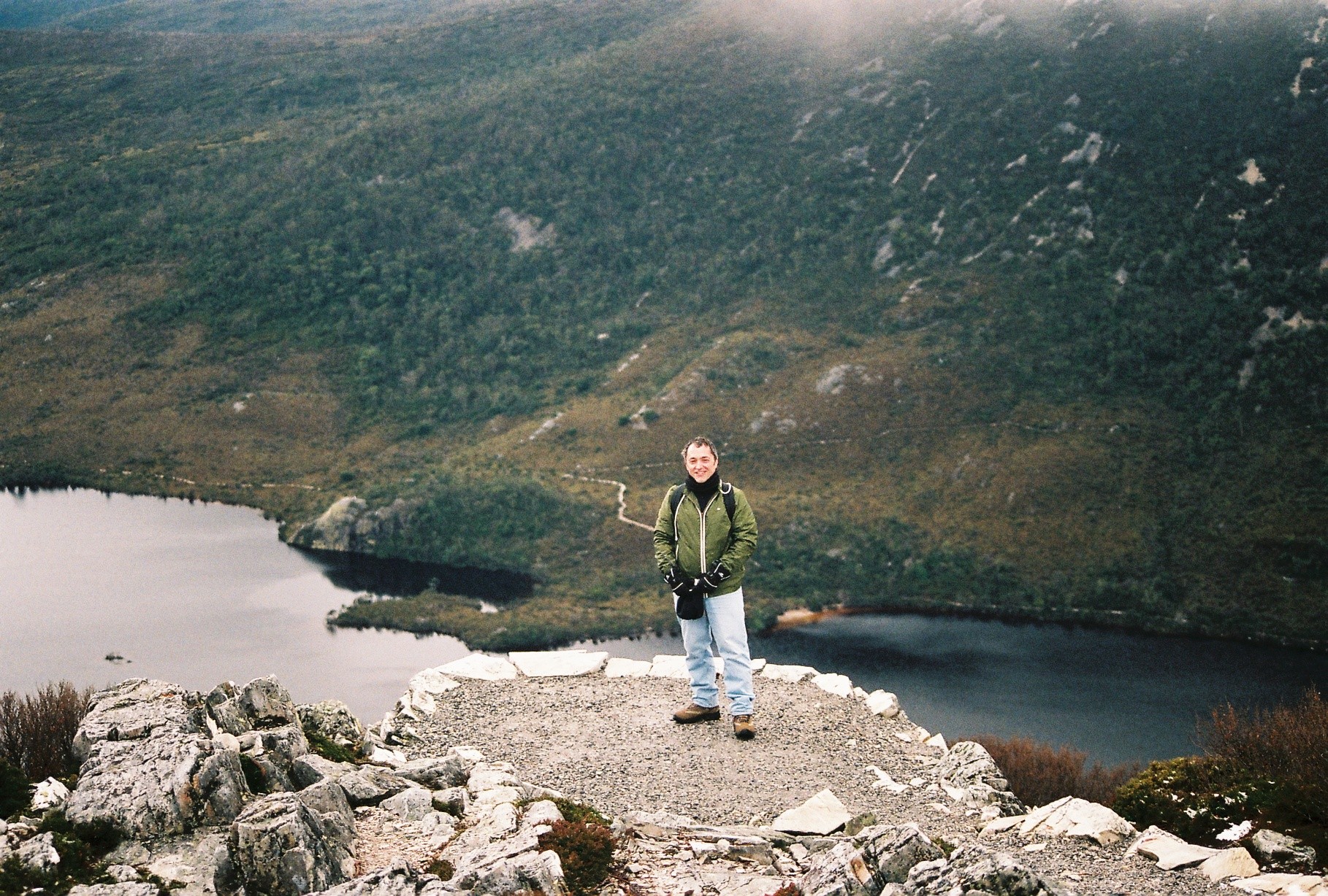
Though we had registered at the trailhead as only planning to go to Crater Lake, we had planned to go to the lookout above the lake.  Upon seeing the lake, we knew that was the right plan!  We embarked on the trail that would take us to that lookout –Marion’s Lookout.  Of course, that meant we were climbing even higher, almost to the peak of one of the hills/mountains (which is it??) around the lake.  Eventually, the route became so steep that a chain handrail was required to be able to climb the steps to the lookout.  At the lookout, the effort was rewarded many times over by the view of Cradle Mountain, Crater Lake and neighboring Dove Lake.  It was very cold at the lookout but that did not matter.  We got to soak in the view and snap a few pix, of course, before descending back to the trail.

View from Marion's Lookout (with the author in the way)

View from Marion’s Lookout (with the author in the way)

We decided to return to the trailhead via Dove Lake, not Crater Lake, so we could enjoy another part of the park.  It was pretty easy to alter our route as the trails were very well signed (though the front desk said to not trust the time estimates on the signs; this must be part of Tasmanian psyche as the Hobart tourism brochure carried ads telling visitors “It’ll take longer than you think” and there were similarly-themed billboards along the road!).

Do Not Feed the Animals – They Feed Themselves Quite Alright, Thank You Very Much!

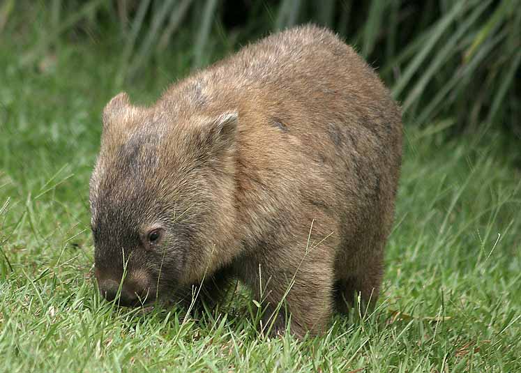
Once we reached the trailhead and the parking area, we went to sign out at the hike registration book (I am glad they ask for this; if someonen gets lost, I suppose someone from the park would know if they see a hike registered in but not registered out).  At the little shelter where the registration book was, we noticed a few pieces of animal excrement and had a good laugh at how wildlife chose to come into the small shelter to take a dump.  Well, we were in for a pleasant surprise when we walked back out and saw a wombat calmly eating grass next to a parking spot just like the one in the picture below (not my pic).   It did not care that humans were around it as it went to town on the grass!  I suppose it first made a stop at the shelter before proceeding to have lunch…

wombat-pic

Headed East

After the hike, we were starving so headed back to the lodge for lunch before departing the park and the area to go all the way to Freycinet National Park on the east coast of the island (a 4-hr drive) to check out Wineglass Bay (see map in my prior entry on Tasmania).

The route we took was less scenic and a “faster” route than our way in which was fine with us.  We got to drive through small towns (where I appreciated the fact that all towns seem to have public restrooms in their squares!) and see a little bit of different scenery.  We bypassed Launceston, one of the main cities on the island, and entered the eastern part of the island as nighttime set in (it begins to get dark here around 430PM and before 6PM, you are in total nighttime).  We could not see the beautiful landscape around us, we would see it the next day.

Finding the next lodge (Freycinet Lodge, http://www.freycinetlodge.com.au/) was not a problem as it was right inside the Freycinet National Park.  This lodge seemed a step more upscale than our prior one (but it was cheaper pricewise).

And Now Time for Us to Feed Ourselves

We were very tired from the hike and looked forward to a nice dinner so after settling in and cleaning up, we headed for dinner.  I had a fantastic pumpkin and rosemary soup and my main dish was a fish called Trevelle.  One of the neat discoveries was this powder called “Bushdust”.  Nothing to do with a U.S. political family, instead it is a mix of nuts and spices that you sprinkle on bread or soup or whatever to spice it up (spice up flavor-wise, that is).

We also made a fantastic discovery:  Milton winery’s Pinot Noir (Tasmanian).  It was quite full-bodied with great flavors and a good finish.  A perfect ending to a great day!


(Pictures taken with Canon EOS Rebel)

Tasmania – Starting Our Visit to a Southern Paradise

Well, I got to Melbourne from Sydney but will delay writing about Melbourne until I have covered more ground here.  Instead, I thought I would share about my very short 3-day visit to Tasmania, a place I only dreamt of ever seeing given how remote it feels to me as a Southeast U.S. resident…  The visit was short but, what a visit!

Getting There

Before telling you about the visit, I first have to comment on how easy one navigates domestic air travel in Australia.  Not sure if that is good (speed, less hassles) or bad (security concerns) but it is certainly different than in the U.S. and parts of Europe.  For domestic travel, you only need to be there 30 mins in advance.  Security lines are short and speedy (TSA, take a field trip to Australia).  Only laptops need be pulled out of bags.  Liquids are OK to carry on.  A breeze!  Of course, feeling sad when saying bye to relatives is just as hard here.  I saw a boy of about 5 with his parents saying goodbye to his grandparents and his uncontrolled sobbing after passing security was truly heart-wrenching…

What to Do in 3 Days in Tasmania?

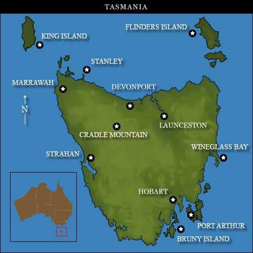
I posed this question in a forum and on Twitter and I think people thought us insane to attempt to cover much ground in 3 days.  Well, it is true that you can only cover so much in 3 days but we were not expecting to do it all or do any one site to its fullest extent.  No speeding up the laws of physics.  We were told to stick around the southeast corner (or so) near Hobart which was not bad advice at all, but I think we had our heart set on a couple of places.  So what did we aim for?  Covering the island (er, state) like the dew…

tasmania_map

Day 1 – Hobart to Cradle Mountain

We took the 7AM flight from Melbourne (one of those sacrifices we had to make…) for the hour-long or so flight over to Hobart.  The flight was smooth as could be (which made me VERY glad we did not take the overnight ferry ride on fairly rough seas…) and getting through the airport and car rental went pretty smoothly and fast.

We decided that we still needed some breakfast and coffee as we expected to have a 4.5 hr drive through the Cradle Mountain National Park to get to the lodge we were going to use as base to see Crater Mountain and the neighboring lakes.  So, before embarking on that long drive, we decided to head into Hobart center to the weekly Saturday market in Salamanca Square.  We had been told it was worth checking out so we got to kill two birds with one stone (does that sound too violent?) and enjoy coffee and a donut while browsing.  The setting was very nice, the produce being sold by the same farmers that grow it, and the arts/crafts section pretty much like any festival in any city I have been to, except some of the arts stuff was more unique to the area.

We began our journey inland following the riverside until eventually we left it and headed to the national park.  The map in this entry may make it seem a straight drive but we went sort of west and then sort of north across a mountain range.  The views were simply amazing; it seemed very lush with eucalyptus and ferns everywhere – and the occasional hydroelectric plant with the huge set of pipes funneling water from up high to the plants for extra push.  The roads got a little windy but not excessively so.  It was definitely a drive we enjoyed.

A Stop in a Queenstown

Around 1:30 PM we stopped at the first town we had seen that seemed to have open businesses (this was on a Saturday afternoon) or, for that matter, that just had businesses!  This town was a mining town called Queenstown.  The neighboring hills/mountains seemed to be iron since the color was a rust color on exposed rock and reddish on rocks that perhaps were more recently exposed.  The town felt like a frontier town though I have never been to a real mining town.  There was no trace of tourists (‘cept us).  We ate at a small eatery (not sure what to call it) – a souvlaki for $6.50AU which was a real bargain compared to any other lunch I have had in Australia!

And Finally to the Lodge!

After another 1.5 hrs of our 4.5 hr trip, we made it to the Cradle Mountain Lodge (not the Chateau) (http://www.cradlemountainlodge.com.au/).  This lodge is close to the entrance to the park and had better recommendations than the chateau.  We really enjoyed the feel of the lodge with its “living room” with a humongous fireplace where we sat before and after dinner sipping nice Tasmanian pinot noir.  Our cabin (our type was called Pencil Pine) was very functional and the day bed was really a full bed and quite comfortable.  Our cabin overlooked a pond and had its own local wildlife right there.  At the lodge you could eat at a restaurant or the tavern and we chose the latter.  The food was actually quite good (I had chicken schnitzel) and had the only TV for the guests which helped one disconnect from the world.  We were exhausted after our early start (and after dinner and some wine) so we called it a night so we could have a decent recovery ahead of our hike the following day.  The lodge offers a number of organized activities from hikes and walks, to movies and wine tastings.  Something for everyone and, seemingly, a place to stay for 2-3 days easily while enjoying nature.

Our first day, though tiring, was quite a succesful day and we thoroughly enjoyed the scenic drive we got to do through the heart of Tasmania.  Here is what awaited us the next day…

%d bloggers like this: