Hiking in Nepal: On the Way to Namche Bazaar! (Day 2)
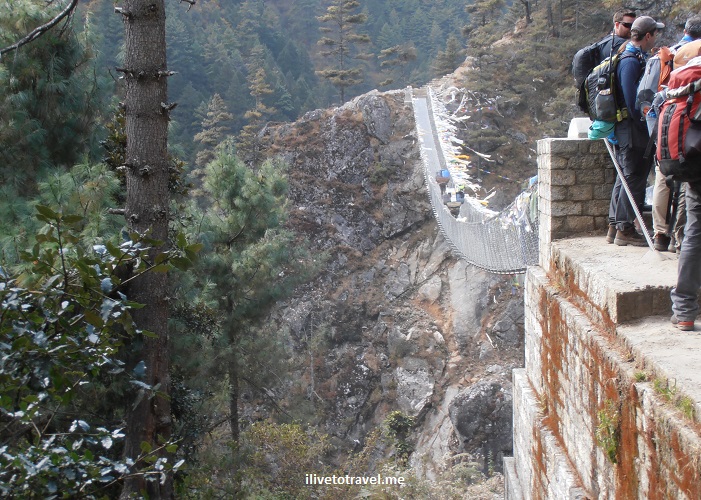
On Day 2, we left our teahouse in the tiny spot of Tok Tok (9,000  ft / 2,800 m) at around 8:45AM to head, following the route to Everest Base Camp, to Namche Bazaar, a rather bigger town than most in the area (actually, THE biggest).  This would have us climb over 2,000 ft in the last 2.5 hours of the hike that day, a rather ambitious and challenging effort (except for the super fit and those used to the altitude, perhaps – I fell under neither success category…).

Leaving our spot in Tok Tok, we stood for a group photo as one of the trekkers was not continuing beyond Tok Tok.

Tok Tok, trekkers, Everest Base Camp, Nepal, Himalayas, trekking

Group photo!

Nepal, Himalayas, trekking, hiking, Tok Tok, bridge, river, Everest Base Camp

Our first bridge of the day was right outside the teahouse – watch out for the pack animals!

On the trail to Everest Base Camp…

Soon thereafter, off we went walking on terrain that was becoming familiar to us:  rocks, dirt, steps, pack animals, farms, debris from the earthquake, reconstruction, and the river.  It is a rugged but peaceful terrain; except when the pack animals come – at that point you make a quick move towards the inside of the trail, not the side facing the steep dropoff!  On this day, we would cross the river four times if memory serves me right.

Everest Base Camp, trail,trek, trekking, terrain, hiking, Nepal, Himalayas, outdoors, adventure, Olympus

Steep climbs every day!

Everest Base Camp, trek, trekking, terrain, hiking, Nepal, Himalayas, outdoors, adventure, Olympus

Pack animals: these were carrying a very light load

Everest Base Camp, trail,trek, trekking, terrain, hiking, Nepal, Himalayas, outdoors, adventure, Olympus

Typical stop for trekkers

Entering the Sagarmatha National Park

Later that morning, we officially entered the Sagarmatha National Park (which is the park where Mt. Everest sits) via the Jorsalle gate (which is right outside of Monju on the way to Jorsalle).  There was signage offering good advice for trekkers in dealing with acute mountain sickness (there are always those who are unprepared…).  More importantly we passed a traditional kani gate which incorporates prayer wheels and colorful paintings on the walls and ceilings.  This gate marks our entrance in the sacred valley of the Sherpa (a term that refers to an ethnic group, not a job, as we learned…):  the Khumbu.  I loved the rules suggested to those who enter the valley (see photo).

kani gate, Jorsalle gate, Sagarmatha, National Park, Nepal, Everest Base Camp, tradition, Buddhist, sacred valley, Khumbu

The kani gate marking the entrance to the sacred valley

Sagarmatha, Kani gate, Jorsalle, Nepal, Himalayas, Buddhist painting, art, color, photo, travel, Olympus

Ceiling painting

Sagarmatha, Kani gate, Jorsalle, Nepal, Himalayas, Buddhist painting, art, color, photo, travel, Olympus

Wall painting and the ever-present prayer wheels at the kani gate

Acute mountain sickness, Nepal, Sagarmatha, warning sign

Warnings about acute mountain sickness

Sagarmatha, National Park, Nepal, kani gate, Jorsalle, park rules, travel

Follow these rules!

Breaks from the trail:  tea and food

While the actual walk is rewarding despite the challenging parts, one of my favorite moments is when we stop 🙂  Yes, it is about getting a break from the effort.  But it is also about the camaraderie over that cup of tea, lemon or mint with the latter being my favorite.  As we all have different paces, non-walking time is when we get to share with those we don’t keep up pace with (or those who can’t slow down easily!).  After tackling the first mile (which was not a walk in the park), we made a restroom stop at Benkar but did not even sit-  this was not our morning break for tea.

Everest Base Camp, trail,trek, trekking, terrain, hiking, Nepal, Himalayas, outdoors, adventure, Olympus

Brief stop to use the ‘facilities’ and take a snack out

Everest Base Camp, trail,trek, trekking, terrain, hiking, Nepal, Himalayas, outdoors, adventure, Olympus

Resuming our hike with a nice downhill

So we trudged along and, after we entered the Sagarmatha NP, we later hit our morning break at Monju (or Monzo) at a place that I would stop at on the way back to Lukla.  The outdoor terrace was very spacious and comfortable (perhaps because we were the only ‘crowd’ there) and the temperature was great so we enjoyed sitting in the terrace sipping our tea!

Everest Base Camp, trail, route, Monju, Monzo, Nepal, Himalayas, Trekking for Kids, travel, outdoors, adventure, Olympus

Tea time in Monju!

And then we proceeded to Jorsalle where, not 30 minutes later, we would have lunch outdoors by the river at a teahouse there.  It was a great stopping point right by the trail (as most are).  It was a good break before the final push, and I mean PUSH, to Namche Bazaar – we would be starting a serious vertical climb over a rather short horizontal distance.  Heaven help me!  We left our lunch ‘resting place’ at around 1 PM.

Jorsalle, Khumbu, Nepal, Himalayas, Everest Base Camp, trekking, trail, Dudh Koshi, river

Approaching Jorsalle, our lunch ‘town’

Jorsalle, Khumbu, Nepal, Himalayas, Everest Base Camp, trekking, trail, Dudh Koshi, river

Lunch time in the sun!

Bridges crossing the Dudh Kosi River

Before I get to the monster climb…  This day was made fun by the many bridges low and high, short and long we would cross.  If you are not a fan of suspension bridges, this may not be your favorite day but the most important thing to mind are the pack animals, not the height of the bridges!  Here are some images from the “day in bridges.”

bridge, Nepal, Dudh Koshi, river, Everest Base Camp, route, Olympus, travel, outdoors, trekking, hiking, Khumbu, Sagarmatha

Pack animals have right of way – if you are smart!

bridge, Nepal, Dudh Koshi, river, Everest Base Camp, route, Olympus, travel, outdoors, trekking, hiking, Khumbu, Sagarmatha

Lovely scenery from the bridge’s vantage point

bridge, Nepal, Dudh Koshi, river, Everest Base Camp, route, Olympus, travel, outdoors, trekking, hiking, Khumbu, Sagarmatha

One of the smaller bridges we dealt with

bridge, Nepal, Dudh Koshi, river, Everest Base Camp, route, Olympus, travel, outdoors, trekking, hiking, Khumbu, Sagarmatha

Beautiful spot (notice the prayer flags)!

bridge, Nepal, Dudh Koshi, river, Everest Base Camp, route, Olympus, travel, outdoors, trekking, hiking, Khumbu, Sagarmatha

Loved walking this close to the Dudh Koshi River

bridge, Nepal, Dudh Koshi, river, Everest Base Camp, route, Olympus, travel, outdoors, trekking, hiking, Khumbu, Sagarmatha

And then we got to this… (the bottom bridge is closed now)

bridge, Nepal, Dudh Koshi, river, Everest Base Camp, route, Olympus, travel, outdoors, trekking, hiking, Khumbu, Sagarmatha

And we are about to walk across the highest one!

bridge, Nepal, Dudh Koshi, river, Everest Base Camp, route, Olympus, travel, outdoors, trekking, hiking, Khumbu, Sagarmatha

View down from the highest suspension bridge

bridge, Nepal, Dudh Koshi, river, Everest Base Camp, route, Olympus, travel, outdoors, trekking, hiking, Khumbu, Sagarmatha

View down from the highest suspension bridge

And our awesome endpoint:  Namche Bazaar

The route to Everest Base Camp is not a steady uphill.  No place ever is (even Mt. Kilimanjaro has its downhills as you climb) but this was as much going down as you have gone up in many stretches.

In fact, this day, on a 5.3-mile (8.5 km) route, our net climb was around 2,300 ft (about 800 m) – we climbed much more (upwards of 4,000 ft) and descended a good bit.  But after lunch what we faced was mostly a severe uphill, especially after the last suspension bridge (the highest one).  And the trail was very rugged to boot.  Hard stuff.  I didn’t know how I could finish it.  And remember, we were climbing to our end point at over 11,300 ft (3,400 m) so the thin air was having an impact (as a reference point, once in Namche Bazaar, we would be at 67% oxygen level vs. sea level!!).  I had to stop every now and then just to catch my breath especially after a stretch where the ‘steps’ (rocks) were higher. Not knowing how much more I really had was both a blessing and a curse.  Certainly I would not want to know how much more most of the way but maybe during the last 30 minutes I would have wanted to know that Namche was THAT close.

With the incredible climb at the end, Namche Bazaar could not have come sooner.   So, it was awesome when we rounded a corner about 2.5 hours after lunch and we saw this town incredibly nested in what looked like mother nature’s own amphitheater:  Namche Bazaar!  It was a photo op moment for sure and we had earned the rest day coming up on Day 3!

Namche Bazaar, Nepal, Everest Base Camp, trail, route, Himalayas, trekking, hiking, outdoors, adventure

I shall name this photo: “The first time I saw sweet Namche”

Namche Bazaar, Nepal, Everest Base Camp, trail, route, Himalayas, trekking, hiking, outdoors, adventure

The moment I stopped when I rounded the corner – best moment ever!

Namche Bazaar, Nepal, Everest Base Camp, trail, route, Himalayas, trekking, hiking, outdoors, adventure

My trek roommate and I celebrating we had survived

——————————————————————————————

Check out other related posts!

Hiking in Nepal: Lukla to Tok Tok (Day 1)

My trek in the Himalayas followed the route to Everest Base Camp.  I only had two weeks’ vacation so I was short one week to make it all the way to “EBC” since my visit to Nepal included an extra number of days to help in the re-building of a school that was destroyed during the April 2015 earthquake in the village of Kumari.  It was a great trip and I did not want to miss seeing Mount Everest in person.  Making that decision was not the hardest part, figuring out what I need to take was!  (Read here for how I packed for the trek!)

However, I went on this trek with Trekking for Kids because I knew some of the folks going and it was not a bad time to be away from work (is there ever a good time??).  So my trek was going to be from Lukla to Deboche, past the Tengboche monastery.  As it turned out, that ended up being a good choice since my stepfather died back home the day before I left Nepal for home.  But, before that turn of events, I was already glad I had chosen to not go all the way.

Day 1 took us from Lukla (2,860 metres (9,383 ft)) to Tok Tok (2,760 metres (9,o55 ft)). While an overall descent, there were plenty of climbs and descents along the way!

Nepal, Himalaya, route, Tok Tok, Lukla, map, trekking, Everest trek, adventure

Our starting point and ending point for day 1

Starting the trek:  getting to Lukla

Starting the trek in Lukla required first getting to Lukla.  As I shared in an earlier post, either one does a local bus and then a few days’ hike to get to Lukla or one flies into one of the “most dangerous” airports in the world:  Lukla (LUA).  I did the latter for a couple of good reasons:  that was what was pre-planned by Trekking for Kids and I didn’t have enough vacation time anyway!

You can read the details in the earlier post but the short of it is:  I made it to Lukla alive and without too much suffering 🙂

Lukla, Nepal, airport, runway, travel, adventure, Samsung Galaxy

The Lukla airport – a very short and dramatic runway!

Getting the trek going:  leaving Lukla

After we landed in Lukla, getting our bags was a piece of cake (the airport is tiny, after all).  From there to our breakfast stop (at a hotel we would return to at the end of the trek) was a very short walk (Lukla is tiny, after all).  We got there and, as we had left Kathmandu at the literal crack of dawn, we proceeded to have some breakfast before heading out.  Our guides had to sort our things with the porters we were picking up in Lukla so we had ample time.  I can’t really recall what I had but nothing too heavy as we were leaving for a few hours’ hike.Everyone was itching to go and, when we finally did, I think we had a little bit of adrenaline flowing!  Close to leaving Lukla, we came to our first gate and prayer wheels and the backdrop was phenomenal in the deep blue sky ahead.  It was a sign of the great day ahead!

Though we started the hike at over 9,000 ft, we warmed up pretty quickly as the hike progressed.  It felt so good!  Hamlets in this part of Nepal are charming probably because of the color applied to the window and door frames and we started noticing this early on.

Nepal, Himalayas, house, hamlet, blue, travel, Olympus, trekkers

Approaching a hamlet

Nepal, Himalayas, house, hamlet, blue, travel, Olympus

House along the trek route

We crossed our first hanging bridge on this day (one of two hanging bridges that day).  It was not too high (I am not afraid of heights, thankfully) and it was certainly long.  We would follow this river all the way to near Namche Bazaar.  We also crossed another bridge, a truss one, that day.  I noticed that some parts of the route, as it passed through small “hamlets,” were paved with stones while others were dirt paths.  It was nice to have the variation in the route – just like it was nice to have all the uphills and downhills mixed.

Nepal, Everest trek, Dhudh Kosi, river, trekking, Olympus

Approaching the Dhudh Kosi River and the hanging bridge

River, Dudh Kosi, Nepal, glacier water, Everest trek, trekking, nature, outdoors

Beautiful waters, courtesy of glacierland!

Buddhist faith along the route

Along the way we passed different-sized prayer wheels and collections of Tibetan tablets (in sanskrit) that are so iconic and that speak to the concreteness of the faith in that region of Asia.  I tried to not miss spinning prayer wheels and we certainly made sure we passed the “monuments” on their left as tradition/faith requires.

stupa, Buddhism, sanskrit tablet, stupa, Himalayas, Everest trek, Nepal, travel, outdoors, faith, religion, photo, Olympus

Sanskrit tablets and a stupa

prayer wheel, Buddhism, sanskrit tablet, stupa, Himalayas, Everest trek, Nepal, travel, outdoors, faith, religion, photo, Olympus

A prayer wheel asking to be spun

A hiker has to eat!

Along the way we stopped for lunch at a beautiful spot where the route made a 90-degree angle.  The place, the Wind Horse Lodge and Restaurant was a perfect spot, idyllic, for the stop.  We sat outside at tables on the small lawn, graced by marigolds along the edges.  Until clouds rolled over and it started getting cold.  We promptly found tables indoors and the lunch was pretty darn good:  fried noodles and rice along with fried mini empanadas (my Latin roots betray me as that is not what they call them there!).

Nepal, Everest trek, food, fried noodles, travel, trekking, teahouse

Lunch!

Ending our hike in Tok Tok

Bellies full and feet rested, we proceeded on our hike.  I try on these treks to not study the route we are going to take as I don’t want to be “expecting” the next stop or calculating how much longer we have to go – I want to enjoy the moment though, I admit, at times when I am feeling tired, I start trying to figure out how much longer I have to go 🙂

We arrived at our teahouse in Tok Tok (River View Lodge) and, as usual, it is a great feeling to hear the words “We are here” when we arrive at our resting place for the night!  It was a tiny spot nestled between a hill and the river.  I wish it had been a tad warmer to stay outside in the evening.

teahouse, room, Everest trek, lodging, Nepal, Himalayas, travel, trekking, travel, Olympus, photo

My room at the teahouse

teahouse, room, Everest trek, lodging, Nepal, Himalayas, travel, trekking, travel, Olympus, photo

The dining room (aka, hanging out room) at the teahouse

In the end, it was a spectacular first day trekking in the Himalayas and I slept well that night!  I leave you with one of my favorite views from that day!

stupa, Buddhism, stupa, Himalayas, Everest trek, Nepal, travel, outdoors, faith, religion

Just magnificent


Other posts related to this hike:

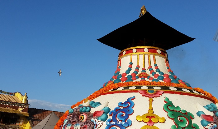
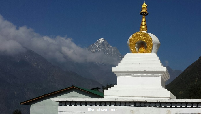
Kathmandu’s Great Boudha Stupa – Still There after the Earthquake

One of the most beautiful sites in Kathmandu, Nepal is its Great Boudha Stupa (or Boudhanath Stupa).  First and foremost, it is a beautiful statement of faith, the largest such Buddhist structure in Nepal and the largest outside of any in Tibet.  That Kathmandu’s Great Boudha Stupa is pleasing to my eyes is a far second from that but, still, for this first time visitor to areas with a strong Buddhist influence, its physical beauty is indeed powerful. 

Sadly, I only got to see if after the earthquake of April 2015 so I missed seeing the stupa tower, the lotus, and the umbrella portions of the stupa which came tumbling down with the quake.

ticket, entrance pass, Great Boudha, stupa, Kathmandu, Nepal, Buddhist, Buddhism, travel, tourism
The Great Boudha Stupa

The stupa:  a place for faith

The stupa is very large in diameter.  The faithful, and those of us who respect them, walk around in a clockwise direction turning the prayers wheels with their prayers and stopping at different points for prayer.  The faithful believe one of the earlier Buddhas is buried under the dome of the structure.

Great Boudha Stupa, stupa, prayer wheel, Buddhist, Buddhism, Kathmandu, Nepal, Samsung Galaxy, travel, tourism, marigold
People stopping for prayers along the way
Great Boudha Stupa, stupa, marigold, Buddhist, Buddhism, Kathmandu, Nepal, Samsung Galaxy, travel, tourism
Marigolds everywhere add color
Great Boudha Stupa, stupa, prayer wheel, Buddhist, Buddhism, Kathmandu, Nepal, Samsung Galaxy, travel, tourism
The prayer wheels
Great Boudha Stupa, stupa, prayer wheel, Buddhist, Buddhism, Kathmandu, Nepal, Samsung Galaxy, travel, tourism
Turning the wheel while saying the prayer

There are some monasteries around it but the buildings around it also house shops and workshops where local artists create their pieces.

Great Boudha Stupa, stupa, Buddhist, Buddhism, Kathmandu, Nepal, Samsung Galaxy, travel, tourism
The district around the stupa
Lhakhang, monastery, Great Boudha Stupa, stupa, Buddhist, Buddhism, Kathmandu, Nepal, Samsung Galaxy, travel, tourism
Lhakhang Monastery
Lhakhang, monastery, Great Boudha Stupa, stupa, Buddhist, Buddhism, Kathmandu, Nepal, Samsung Galaxy, travel, tourism
Entrance to the Lhakhang Monastery

My favorite visit was to a shop with its associated workshop on the second story.  We got a nice explanation of the “emblematic” paintings we laymen just associate with Tibet and saw a few of the artists at work, painstakingly working on their creation.

Tibetan art, painting, Great Boudha Stupa, stupa, Buddhist, Buddhism, Kathmandu, Nepal, Samsung Galaxy, travel, tourism
Artist at work

The stupa:  a place of beauty

Halfway around our walk, we got up and a little closer to the dome which still remains unapproachable due to damage for the quake and on-going repairs to the site.  From there, one gets to higher ground to look around and get closer to the items near the dome.  I leave you with some final photos that are evocative of the beauty of the entire site!

Great Boudha Stupa, stupa, dome, Buddhist, Buddhism, Kathmandu, Nepal, Samsung Galaxy, travel, tourism, color
The damage to the dome is evident
Great Boudha Stupa, stupa, dome, Buddhist, Buddhism, Kathmandu, Nepal, Samsung Galaxy, travel, tourism, color

Building a School in Kumari, Nepal
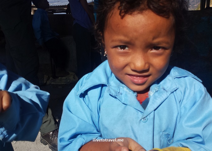
Prior to my trek in the Himalayas along the route to Everest Base Camp, I spent 3 days in the village of Kumari, Nepal thanks to Trekking for Kids‘ work to support this village.  The village, as many places in Nepal, was severely impacted by the April 2015 earthquake that struck the country.

The recently-built medical clinic was quite damaged and the school that served about 400 children was pretty much destroyed.

Nepal, earthquake, damage, Kumari, medical clinic, Nuwakot

Most damaged part of the clinic

Trekking for Kids had planned a trip to Nepal (it has been going there for years to bring hope to orphaned kids via its treks) and chose to direct the funds raised by us trekkers towards the re-construction of the school.  The school certainly will provide a better environment for the kids to receive education but it will also encourage parents to send the kids to school which helps reduce the risk that human trafficking poses for these children.

Kumari, Shree Bikash, school, Nuwakot, Nepal, Trekking for Kids, voluntourism, service, Samsung Galaxy

Makeshifts structures -and outdoor spaces- serve as temporary classrooms

Kumari, Shree Bikash, school, Nuwakot, Nepal, Trekking for Kids, voluntourism, service, Samsung Galaxy

Teacher holding class outdoor

Our stay in Kumari

We left Kathmandu on our way to Kumari, a village development center in the Nuwakot district.  Though it seems to be about 30 miles from Kathmandu, as the eagle flies, it took us about 3.5 hours.  The first 1.5 hrs were on a paved road that we left after a quick stop at a roadside kiosk.  From then on, we took a dirt and bumpy road that in the rainy season is impassable, driving past terraced hills and lots of green.  Occasionally we would pass small rural homes and saw a little bit of life in the countryside.

In Kumari, we stayed in the medical clinic compound, a very large space that was fenced and gated.  The medical clinic laid near the far end and had been badly damaged by the April 2015 quake.  Though damaged, a couple of spaces were still in use for examinations and to house the pharmacy.  Behind the clinic, there was a small structure housing the women’s and the men’s restrooms (2 stalls each) plus one basic shower.  Along the sides of the compound were tents used by our group and others supporting the construction work and our visit.  I imagine the tents were donated post-quake to help with temporary housing for locals but I think I heard tents were not very successful in Nepal as they were too foreign for regular folks.  Not sure if our tents were indeed originally intended for that temporary shelter but they look pretty clean and unused.  I will have to say that they were a little larger than the small two-people tents I have used before so I was glad for the extra “comfort.”

Sukman, medical clinic, polyclinic, Kumari, Nuwakot, Nepal, photo, Samsung Galaxy

The Sukman Memorial Polyclinic, our tents to the right

Staying in the compound was far better than I had been expected.  The grounds are well kept, the indoor restroom was a pleasant surprise, and though I only used it one of the 3 days, it was nice to take a shower after a day’s hard work.  The compound also had a kitchen and outdoor (covered) seating area so all our meals were there.  I tended to wake up very early and enjoyed a cup of tea while soaking in the quiet and sunrise.  It was a little cold at night but not frigid.  We were a 5-minute walk to the work site (the school grounds) so all-in-all, I was pleased with the setup they had prepared to host us, not having too much time traveling to- and from- the work site so we could maximize time at the site.

A grand Kumari welcome!

When our small caravan was approaching the medical compound, we noticed a lot of people were there waiting for us.  The more we walked, the more it seemed the entire district had come to welcome us.  We left our stuff in the cars (someone would take care of that) and after an initial greeting which included music, we were taken up a dirt road towards the school grounds which were located above the medical compound.

Nepal, Kumari, Nuwakot, voluntourism, trekking

Walking from the clinic to the school grounds

As we made the final turn up the dirt road that passes the school grounds, we noticed schoolchildren were lined up waiting for us – loaded with long necklaces made from orange marigolds (like Hawaiian leis).  As we walked along the kids, teachers, and others, these “leis” were placed on our necks.  They must have spent long days making these (the flowers were all fresh)!!  Some of us ended with a heavy yoke of these leis around our necks but it was a very joyful welcome – much appreciated!

Nepal, Kumari, Nuwakot, marigold, schoolchildren

Schoolchildren awaiting us with the marigold necklaces!

Marigold, necklace, lei, trekkers, Trekking for Kids, photo, Samsung Galaxy

Some of us sporting the massive and heavy leis

After we got to the covered space that had been set up for the welcome ceremony, we took our seats and then all the children and other locals stood behind us.  At the end of the ceremony, 3 hours later or so, I was very impressed the locals stayed the entire time, in the sun.  There were some local figures present but maybe the draw was the two emcees (MCs) who I take had come from Kathmandu and were well-known.  The ceremony entailed many speeches in Nepali or in English as well as some dances/songs by the local kids.  I soaked it all in though, at that point, none of us had eaten anything since breakfast and I, for one, was hungry and trying hard not to pull something out of my day pack when so many in the crowd were probably as hungry as I was.Mukari, Nuwakot, Nepal, trekking for kids, photo, school children, Samsung Galaxy, travel, voluntourism Mukari, Nuwakot, Nepal, trekking for kids, photo, Samsung Galaxy, travel, voluntourismMukari, Nuwakot, Nepal, trekking for kids, photo, school children, Samsung Galaxy, travel, voluntourism

Mukari, Nuwakot, Nepal, trekking for kids, photo, school children, Samsung Galaxy, travel, voluntourism

School administrators, civic organizers, the MCs and the trekkers

Sweat equity

Trekkers like me commit to fundraise $1,000 towards the projects chosen for the specific trek.  The projects funded are normally anchored on capital improvements or new infrastructure.  In this Nepal trek, the school was the main project our funds would support.  I am proud to say that my group of trekkers and I raised over $33,000, much higher than the minimum we each committed to raise (thanks to any of you who donated!).  This allowed us to also fund the construction of new indoor restroom facilities at the school, something the children had never had before:  one restroom with several stalls for the girls, and the same for the boys.  When I go in these treks, I often leave pondering the things I have taken for granted all my life… and I am humbled at the blessings in my life.

Shree Bikash, school, Kumari, Nuwakot, Nepal, construction

Plans for the new school

One of the three days was focused on us pitching in in the construction efforts.  Trekking for Kids’ approach is to ensure local labor performs the projects and local materials are used.  But trekkers get to get down and dirty lending a hand.  In these projects, trekkers got to help both with preparing the foundation for two of the new school buildings as well as with pouring the new roof for the restroom building.

Kumari, Shree Bikash, school, Nuwakot, Nepal, Trekking for Kids, voluntourism, service, Samsung Galaxy, construction

Foundation trenches completed, next step was to lay rocks at the bottom

I worked in the crew that helped dig the trenches for the school buildings’ foundations and then “harvested” rocks from the debris field from the former school building from the side of the hill and tossed them (via human chain) up to fill the bottom layer of the trenches.  While we were happy to help, it was clear the locals who worked on the project and the local teen youth group that was volunteering to help were much more effective and fast than we were…  It was certainly an honor to be able to humble ourselves for such a good cause.

Other trekkers helped prep the restroom roof before the concrete was poured by framing the area and cutting and setting up the rebar.  At the point the concrete was being mixed and poured, the locals took over.  It was interesting to watch their methods!

Rebar, Nepal, Kumari, school, Trekking for Kids, voluntourism, volunteer, travel

Cutting rebar

construction, Kumari, Nepal, school, voluntourism, Trekking for Kids

Roof being readied for the concrete pouring

Kumari, Nepal, Trekking for Kids, construction, Shree Bikash school, Nuwakot, voluntourism

Roof being poured with the sewage tank visible in the lower part of the photo

Finally, our trekkers helped finish the digging of the “sewage tank” that had already been started with the use of mechanical equipment.  Hard work indeed!

And just having fun

Working on the projects is something trekkers enjoy doing but trekkers always enjoy the opportunity to be with the kids.  The kids made us smile with the great welcome they gave us so I certainly enjoyed giving back in this way to them.  We got to be with the kids during school hours and afterwards, including one afternoon dedicated to fun and games that went late.  The kids thoroughly enjoyed the mini-carnival games, the arts and crafts, and a good early dinner!

Nepal, Kumari, Nuwakot, school, Trekking for Kids, voluntourism

One of our trekkers, a former teacher, spends time in the classroom

Nepal, Kumari, Nuwakot, school, voluntourism, Trekking for Kids, Samsung Galaxy

The kids played games in the afternoon

Nepal, Kumari, Nuwakot, school, voluntourism, Trekking for Kids, Samsung Galaxy

Kids enjoying an early dinner

Nepal, Kumari, Nuwakot, Shree Bikash, school, Trekking for Kids, voluntourism, Samsung Galaxy

At the end of the day, kids line up for parting gifts!

As for me

The treks themselves, of course, helped keep me challenged and appreciating my own life’s blessings.  But, in the end, I would not be doing these treks if it were not for the opportunity to make a difference, however small, in the lives of children around the world.  It is faces like these that keep me prioritizing my travel budget and vacation time for doing these treks (at the expense of doing more with my own friends and family), that keep me “pestering” friends and family for donations to fund the projects, and that keep me accepting conditions during my treks that are less than what I’d prefer during my vacations.  Take a look, can you blame me?Kumari, Nuwakot, Nepal, kid, child, school, service, volunteer, Samsung Galaxy, photo, travel Kumari, Nuwakot, Nepal, kid, child, school, service, volunteer, Samsung Galaxy, photo, travel Kumari, Nuwakot, Nepal, kid, child, school, service, volunteer, Samsung Galaxy, photo, travel

Check out Trekking for Kids and pass the word about this great organization to others via word of mouth and social media!

Nepal, Kumari, Nuwakot, sunset, mountains, travel, Samsung Galaxy

A beautiful Nepali sunset over our camp

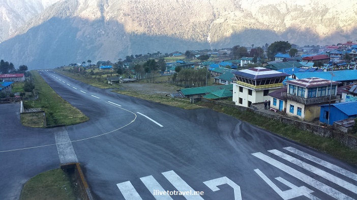
Flying into Dangerous Lukla Airport in Nepal

I recall seeing a few years ago a TV show about the world’s ten most dangerous airports. Tegucigalpa, St. Maarten and a few others made the list.  And so did Lukla, Nepal.  Lukla is the typical starting point for anyone trekking along the route to Everest Base Camp, or to other points in the Himalayas. The alternative to the 35-min flight to Lukla (LUA) from Kathmandu is a long bus ride plus a few days of trekking to reach Lukla. I was not thrilled at the prospect of landing in one of the most dangerous airports but there really was no choice.

Heading to Lukla

The Lukla airport was built by none other than Sir Edmund Hillary himself in 1965 to facilitate developing the trekking business that he felt the local population needed.  The Lukla airport , officially named Tenzing-Hillary Airport after the first two people to have summitted Mt. Everest, was a dirt airstrip until just 1999.  Lukla is a town of a few thousand inhabitants perched high at around 2,840m / 9,300 ft above sea level.  Flights in and out of Lukla mainly fly in the morning when the weather and the visibility are what they need to be for a successful flight (read: does not crash).  Only planes that can handle short takeoffs and landings can operate from Lukla as the runway is only 1,700 ft (500m) long (or so) – that ain’t long at all!  Flights can easily be canceled for the day if the conditions are not right which could be more than one day in a row, leaving hundreds stranded in this small hamlet in the highlands of Nepal…  So beyond the flight involving a “dangerous” airport, one gets to worry about will the flight even go and what happens to the rest of the itinerary if the day is bust…

In any case, there are several airlines that run flights continuously in the morning to and from Lukla.  It is like a bus service of sorts with planes making quick turnarounds at either airport (Lukla/Kathmandu) to take advantage of the right weather.

Lukla, Tara Air, boarding pass, Nepal, flight, airline, travel, Everest

Boarding pass to Lukla

The domestic terminal in Kathmandu is small and easy once you get past the chaos of getting to the airline counter and checking in.  We had no real problems, thanks to our local guides that were going to be traveling with us – they knew their way around!  After being dropped off, we walk along a covered walkway to a building in the back past a new building under construction.  The old building was old indeed but it was functional.  Once the flight is called (other Lukla flights were called too), we stepped out and there were 2-3 buses awaiting to take people to their planes.  It was a bit confusing and finally someone pointed us to our bus based on our boarding pass.

The plane sat maybe 20 people and the flight was not full.  I got a seat on the left so I would be facing north (towards the Himalayas).  Unfortunately, the windows were very dirty which assured that photos would not be National Geographic kind of material (that is my excuse anyway…).  Gosh, if I’d known and they’d let us, I would have gotten off the plane pre-takeoff and cleaned my window!

Himalayas, Nepal, window seat, airplane, flight, Tara Air, Lukla

The taller Himalayas via dirty window

Himalayas, Nepal, window seat, airplane, flight, Tara Air, Lukla

At times, the ground was not far below us…

Himalayas, Nepal, window seat, airplane, flight, Tara Air, Lukla

Small village – one can see the local stupa left of center

Before taking off, the flight attendant (yes, there is one) checked that our seat belts were fastened and handed out hard candy (to choke on when the plane jumped?? no, thanks) and cotton balls for our ears – yes, I guess it was to be a noisy flight!  Those tasks and getting us in and out of the plane was all she had time to really do on such a short flight.  But I still appreciated her for taking care of us!

Dangerous Airport?

The danger reputation stems from the fact that the runway starts at the edge of the mountain and runs uphill (a 12% grade) until either the plane has stopped and turned or, it has met the wall.

Lukla, airport, Nepal, dangerous, Himalayas, travel, flight, airplane, landing, takeoff, runway

The full runway (control tower on the right)

I have read, and was also told by a pilot, that part of the issue with landing is the uphill nature of the runway with the far end being higher than the end nearer to the pilot – this situation can trick the eye, giving the pilot a false sense of the aircraft’s vertical position before landing, potentially leading to accidents.

Lukla, airport, accident, danger, Nepal, runway, flight

A plane meets the wall

On the reverse (the takeoff out of Lukla), either the plane catches air at the end of the runway where the runway meets the cliff’s edge, or it drops when the runway runs out until the plane catches lift (which I would hope it does…).

Lukla, airport, flights, Nepal, runway

See what I mean about “up or drop” (Source: www.theaustralian.com)

Truthfully, and maybe naively, neither landing nor takeoff worried me much. What worried me the most was the turbulence that can be encountered on the way to and from Lukla.  Not helping things was the name of our Nepalese airline:  Tara Air.  I was happy until someone pronounced it, making it sound like “terror air” (pronounced with a thick Boston accent) which sent images flying (pardon the pun) all across my brain of a small plane jumping around due to high winds – a terror inducing ride ahead?  Hopefully not!!!Tara Air, Lukla, Kathmandu, Nepal, flight, airline, airport, Himalayas, trekking

Upon boarding, I looked into the seat pocket in front of me and found the air sickness bag which left no doubt as to what its purpose was…  I should have taken it with me but at least I took a picture of it.Tara Air, Lukla, Nepal, air sickness bag, vomit bag

The flight into Lukla had gone very smoothly – no turbulence at all!  And then we started circling.  I was thinking to myself:  “so close and now we start circling” – was it weather-related, I wondered?  The delay turned out to not be about fog or weather issues and we experienced no turbulence.  The issue was that, since the Lukla airport only has four parking spots for planes and they were “taken,” we had to wait for a plane to take off before we were allowed to land.  That was a new one to me!  The flight back from Lukla was also completely smooth giving me a 2-for-2 no-turbulence flights so I may consider never going back since I had such good luck on my first visit to Lukla!

Back to landing in Lukla:  it was pretty darn cool as the small plane’s cockpit was open for us to see what was ahead – including seeing the runway ahead as we landed – or the mountains we were flying into before that.

Lukla, airport, flight, Nepal, cockpit, cockpit view, Himalayas, airplane

The view out of the cockpit – how cool is that!

Leaving Lukla, the plane actually took off the ground before the runway ended so no drop was experienced, maybe to the chagrin of those in the plane who love roller-coasters – but not me!  Here is a video of my own takeoff – notice when we leave the runway, right before it ends (it is a noisy video so make sure you are not at max volume!).

In the end, as you may surmise, this was a far better choice than the bus and the walk 🙂  And now I can say I “survived” one of the world’s most dangerous airports!

ilivetotravel, Raul Pino, flying, window seat, travel, Lukla, Nepal, Tara Air

Happy flyer – and dapper too!


Pin this crazy airport to your travel board!

most dangerous airport, scary flight, flying into Lukla, Nepal, airport, Everest

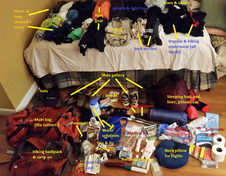
How Does One Pack for A Trek in Nepal?

In about 6 days, I leave on a trip to Nepal.  Once again, I will be trekking with Trekking for Kids to improve the lives of children around the world.  This is a special trip for several reasons, one of which is the devastation from the April 2015 earthquake calls for the world’s support for this developing nation.  It has been long enough where our presence will not be a hindrance to the important efforts that happen immediately post-earthquake.  Our aim is to fundraise the monies needed to re-build the school in the remote village of Kumari, pretty much destroyed during the earthquake and still not recovered.  The school serves about 400 children and we got news this week that the building permit and plans were approved by the local authorities.  If you would like to contribute, please visit my fundraising page and donate, nothing too small (or too big!).  After we visit Kumari and spend a few days with the kids and doing some projects, we will depart to do a 5-day hike that, weather permitting, will allow me to see Mt. Everest in person.  I will not be going to Everest Base Camp as it takes an extra week that I cannot afford with work but that’s OK.  I will get to spend time with some folks I have trekked before and I am looking forward to that!

So the point of the post was to share with you how it looks to pack for this type of trek with multiple elements to it.  This is my spare bedroom, all loaded with my stuff.  Now, to figure out how to fit it in the orange bag on the left and the hiking backpack that will serve as my carry-on piece.  Wish us luck!

hiking, trekking, packing, Nepal, trip, travel


The Warm Capitals: Panama City, Manila, San Juan, and Port of Spain

For many, the ideal vacation is to go where it is sunny and warm, be it the tropics or somewhere with good “Mediterranean” climate.  Be it the Caribbean, the South Pacific, or the Greek Isles, sun and fun seem to go together.  I am not as much a chaser of these climates but they definitely present great color and usually interesting and, pardon the word, warm peoples.  For the “Capital Cities” series,  I have chosen four warm capitals:  Panama City, Manila, San Juan, and Port of Spain.

Panama City, Panama

I have shared before about incredible and ever-changing Panama City, a place I have visited over four different decades and which I always enjoy.

Panama City, Panama, tropics, modern vs. old, photo, travel

Modern Panama City as seen from the Casco Viejo

As I have family there, I get to do both the things a visitor would do but also live a little like the locals when I am there.  Panama City is both old and modern and whether by visiting the old ruins of the original establishment, or exploring the old (but not as old) city or “Casco Viejo,” or entering the Canal Zone, or simply enjoying the modern life, Panama City offers great experiences.  And when those are not enough, then fly to the Pearl Islands or head to other beautiful parts of the country like the area near Chagres or Chiriqui, for example.

Manila, The Philippines

I have only visited Manila once and for a rather brief visit.  I shared in another post how the old district has much more history than I understood from centuries of Spanish rule, then American control, then Japanese occupation, and –finally- from the times after it gained its independence.

Intramuros, Manila, city walls, Manila Town Hall, Philippines, golf course, clouds, sky, Olympus

Looking from the Bayleaf’s Sky Deck towards the Manila Town Hall (notice the golf course)

While it can be quite hot and humid (as Panama City), the warmth of the people is well worth the warmth of the climate.  You’d expect that people in any large city would be short-tempered, always in a rush – a la Manhattan.  Not in Manila, where it seems the human connection is most important.  I did not get to venture outside of the city to enjoy what I hear are incredible beaches and other natural settings worth exploring.  But the city alone was well worth the visit!

San Juan, Puerto Rico

You may know from prior posts that I grew up in Puerto Rico.  We moved there when I was two and I left at 17.  15 years to make San Juan a piece of my heart, as the lovely song says:  “En mi Viejo San Juan, cuantos cuantos sueños forjé en mis noches de infancia…”  The old part of San Juan is referred to as “el Viejo San Juan” to distinguish it from the more modern city around it.

El Morro, fortress, San Juan, Puerto Rico, fields, kites, Caribbean, view, vista, photo, travel, Canon EOS Rebel

Great fields facing the ocean (note the kites and the city walls) in El Morro

The small island where old San Juan sits is connected by bridges to the rest of the city and, if you don’t pay attention, you may not catch that.

Old San Juan is truly a living museum.  Centuries old, it has not been destroyed nor significantly burned so what you see is what it was and has always been.  But it is not a lifeless museum or collection of old buildings:  people work, shop, play and live in those old buildings!  The heat of the tropics is kind in Puerto Rico due to the strong breezes coming in from the Atlantic, at least on the northern and eastern side of the island so Old San Juan is a great place to spend time as it sits higher than sea level for the most part and the breezes, combined with the shadows the buildings offer part of the day, make it comfortable even for the most cold-loving snowbird.  When you go, make sure you explore the old forts and walls erected by the Spanish centuries ago.  For more of what to see in this incredible place and the rest of Puerto Rico, check out my recommendations on experiences to have in Puerto Rico!

Port of Spain, Trinidad & Tobago

The capital of Trinidad and Tobago sits in the island of Trinidad.  Facing the water but with hills around it, it is a melting pot of races and cultures which results in a fun place to discover, even when it is not Carnival (which I hear is phenomenal!).  I visited for a few days and enjoyed GREAT food (whether Italian, Indian, tropical, or other!).  I loved driving around the neighborhoods and seeing some neat island architecture.

Trinindad, food, fish, rice, tropical, travel

A delicious lunch at Veni Mangé in Port of Spain was well-deserving of thanks!

While Port of Spain definitely has an industrial side to it, it has many other awesome areas to spend time in – and don’t forget Maracas Bay not too far away (passing through a beautiful tropical forest and great ocean views from the road!).

Port of Spain, Trinidad, Tobago, architecture, dark sky, travel, photo

Great architecture in Port of Spain!

Port of Spain, Trinidad, Tobago, architecture, dark sky, travel, photo

Modern architecture? Check!

The world has many capitals in the warmer climates.  In fact, quite a bit!  Here is to getting to explore many more of them!  Have any recommendations??

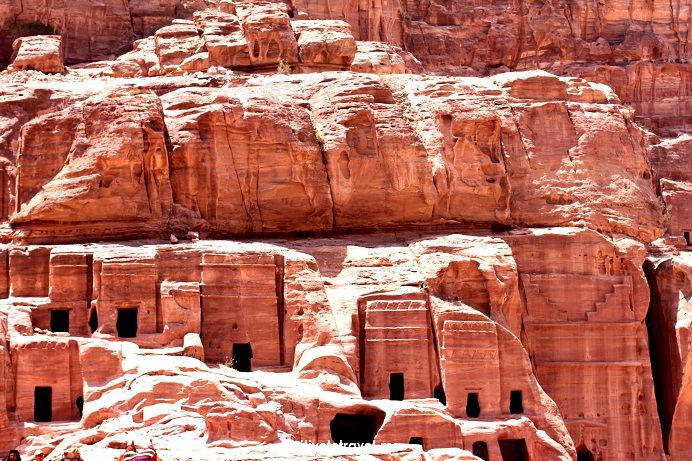
Admiring History on the Rocks in Petra, Jordan

I first went to Petra, Jordan back in 1998 on a day trip from Sharm-el-Sheikh at the southern tip of the Sinai Peninsula in Egypt.  If you know the lay of the land, that may sound impossible.  Well, not if you take a flight from Sharm-el-Sheikh to Aqaba, Jordan and then hop on a bus.  That’s exactly what I did.  I did not have the luxury of time so it was an either do it on a day trip or not do it.  Since I could not predict the future, I had to go for it to be sure I got to see Petra in case I didn’t get to come back.

Petra, Jordan, Nabatean, archeology, ruins, history, necropolis, ancient site, exploring, Middle East, travel, photos, Canon EOS Rebel
Headed to Petra
Petra, Jordan, roads, travel
Great vistas along the way

Return to Petra

Fast forward 15 years and I return to this necropolis-turned-town-turned-movie-setting-turned-massive-tourist-site.  I was thrilled at the opportunity to return and explore it on more depth.  You see, in my first visit, I decided to walk my way in which is great in many ways but it eats away precious time for someone on a day trip there from Sharm-el-Sheikh.  The second time, while I did walk in, I walked faster knowing time was precious and I rented a donkey to take me up to save time.  That was a great idea except that the donkey preferred the edge of the path on the way up rather than risk hitting itself against the rocks at the other side of the path, making this rider a little bit worried about the way down!

Petra, Jordan, Nabatean, archeology, ruins, history, necropolis, ancient site, exploring, Middle East, travel, photos, Canon EOS Rebel, donkey, ilivetotravel, donkey
Donkey in the shade – smart!
Petra, Jordan, Nabatean, archeology, ruins, history, necropolis, ancient site, exploring, Middle East, travel, photos, Canon EOS Rebel, donkey, ilivetotravel
Giddy up!
Petra, Jordan, Nabatean, archeology, ruins, history, necropolis, ancient site, exploring, Middle East, travel, photos, Canon EOS Rebel, donkey, ilivetotravel
Look Ma, no hands!

Thanks, Nabateans

Petra is amazing due to how it has evolved over time but it was the Nabateans who deserve the credit (after God, of course) for this place.  Certainly, the landscape and topography are thanks to the Maker but what happened after that really starts with the Nabateans who carved a necropolis out of these beautiful rocks.  Others, like the Romans, continued to develop the site to what we know now.

Petra, Jordan, Nabatean, archeology, ruins, history, necropolis, ancient site, exploring, Middle East, travel, photos, Canon EOS Rebel, donkey, ilivetotravel, canyon, stone
Some of the tombs around Petra that later peoples used for other purposes – like commerce
Petra, Jordan, Nabatean, archeology, ruins, history, necropolis, ancient site, exploring, Middle East, travel, photos, Canon EOS Rebel, donkey, ilivetotravel, Roman amphitheater
The Romans put Petra to good use

More than the Treasury

You can see evidence of amazing early engineering when you see the channels that were carved into the rock to capture the rare rainfall that rolled down canyon walls and take it into a natural “holding tank.”

Petra, Jordan, Nabatean, archeology, ruins, history, necropolis, ancient site, exploring, Middle East, travel, photos, Canon EOS Rebel, donkey, ilivetotravel
Channel that collected rainwater from the canyon walls and directed to a well

Also impressive are the facades of the tombs built into the rocks such as the Royal Tombs and other areas like the Monastery and the very famous Treasury, which many think to be what the Indiana Jones movie showed.  In reality the Treasury is more of a facade.  Be sure to get a guide who explains to you what you are looking at as the Treasury, for example, shows evidence of how it was carved out of the stone.  And be sure to go all over!

Petra, Jordan, Nabatean, archeology, ruins, history, necropolis, ancient site, exploring, Middle East, travel, photos, Canon EOS Rebel, donkey, ilivetotravel, Royal Tombs
The Royal Tombs from a distance
Petra, Jordan, Nabatean, archeology, ruins, history, necropolis, ancient site, exploring, Middle East, travel, photos, Canon EOS Rebel, Royal Tombs
Some of the Royal Tombs

My advice if you are visiting Petra and don’t have but a day or two is to use a donkey for some of the climbs (unless you want or need the exercise) and then walk and explore – this way, you will maximize what you will see from this one-of-a-kind place and there is PLENTY to see and admire about this unique site.

Petra, Jordan, Nabatean, archeology, ruins, history, necropolis, ancient site, exploring, Middle East, travel, photos, Canon EOS Rebel, Treasury, ilivetotravel
My family “came along” with me to Petra!

During my second visit to Petra, I was a guest of the Jordan Tourism Board.  That notwithstanding, the stories I share were my real experiences and nothing else.  As they always are!

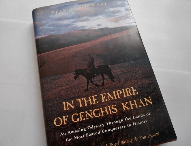
Travel Inspiring Reads – In the Empire of Genghis Khan

Stanley Stewart shares with us in his book about his travel through the lands of Genghis Khan.  Even before he gets to Mongolia, you get to enjoy his anecdotes from traversing what is to me an obscure corner of our planet:  Central Asia.  And, I may add, a part of the world I am dying to explore myself, inspired partly by another book I reviewed earlier:  The Alluring Target.travel, book, good read, Genghis Khan, Mongolia, Central Asia, inspiring, entertaining, anecdotes

Stanley, or “Stalin” which was the closest some people could get to his name, shares about his journey which started in Istanbul, crossing the Black Sea on a ship where he met some interesting characters.  Two of those characters in this ship, which was no cruise liner, Anna and Olga, were described as a “dramatic illustration of the way that Slavic women seem unable to find any middle ground between slim grace and stout coarseness.”  And this will be the freedom that he uses along the book to describe his experiences and the sights.  His observations are funny and truly helped me picture the scenes.

He hits Sevastopol, recently in the news to the Russian invasion of the Crimea, and eventually trains his way across parts of Russia eventually exiting it at Kazakhstan.  Perhaps Russia invaded the Crimea this year to get Sevastopol because, as he explains, back in Soviet times, Russians from Moscow would go down there “just to look at the vegetables.”  LOL, Putin just needs some fiber!  He also finds -and shares with us- wisdom he gets from a Russian:  “In Russia, everything takes time.  We have a saying: ‘The first 500 years are always the worst.’ ”  Good news:  no dictator lasts even a fifth of that, right?!

In any case, the author keeps moving east and begins talking more about the focus of this epic journey:  Genghis Khan.  He explains how Genghis could not respect towns as he was a nomad from the steppes, who viewed townsfolk with pity, from “a position of cultural and moral superiority” while viewing settled farmers as nothing more than a “flock of sheep.”  The freedom of the nomadic life was highly valued.  Therefore, destroying these settled peoples did not trouble good ole Genghis.  Mongols were seen at the footsteps of Vienna but like the Ottomans later, they did not make it there.  No, it wasn’t a Polish king that saved Vienna from the Mongols (like from the Ottomans) but it was an odd thing that kept them out:  the Khan of those days died; and all the Mongols had to haul back to the capital to be part of the election of the next Khan.  So just like that… poof! … they left and Europe was spared further destruction.

One of the reasons I enjoyed this book so much is this mixing of the observations of a traveler with the historical info, all giving me enjoyable insights into this part of the world.  For example, he describes Bishkek, the not-well-known capital of not-well-known Kirghizstan as a “sweet provincial place of tree-lined streets” – it only makes me want to see this place along the Silk Road with my own two eyes.

In another part of the adventure, he describes visiting a highly isolated monastery of only two monks who seemed to have barely escaped the 11th century… and stayed at the 12th century.  Further on, he describes flying into Mongolia since there was no land route with an open border in that corner where Russia, Kazakhstan and Mongolia meet.  The plane was from a company with only one commercial flight that was clearly not regulated by any aviation authority.  No, no, it was not Aeroflot.  He lands in the town of Olgii which proves to him that “Mongolians are not very good at towns.”  He elaborates that it had “an apocalyptic air,” a town “built by people who hate towns.”  Good stuff!

Through his time with his Mongolian guides, he learns about the Mongolian worldview.  Choice stuff.  Like:  “We hate the Chinese… And the Chinese hate us right back.”  Stanley points out that no better evidence of the latter than the Great Wall itself, to keep the barbarians out:  “To the Chinese, the Mongols are the neighbors from hell.”  I am not sure about that.  Let’s ask the Tibetans, shall we?  Another great nugget into this relationship is the Chinese saying he shares:  “When Mongolians party, the rest of Asia locks its doors.”  So the Mongolians, it would seem, would belong in the SEC if they had a college football team.

And the insights into how Mongolians live are aplenty.  For example, we read about the wrestling competition where the jackets worn by the wrestlers have long sleeves but are open in the front.  That’s to be sure no women wrestlers pretend to be men.  You see, he explains, women wrestlers are well feared in Outer Mongolia and, this way, they keep men wrestlers from getting hurt…  Another insight is why jeeps tend to have no door handles on the left hand side of the vehicle:  jeeps, like horses, should only be mounted from the right hand side.  A final insight I will share here is how nothing “horrifies Mongolians quite like the admission that foreigners, like animals, regularly consume raw leaves.”   Horrifies me too.

Now, I am NOT going to take that crazy flight into Mongolia by a local airline with one plane…  Nor am I looking to spending weeks on horseback, much as his crazy horses sound like a barrel of laughs…  But I have to say that the anecdotes, the observations, and the facts shared make me wish I’d been right along him -not all the time- in this journey and feed my hunger to meet Central Asia some day!

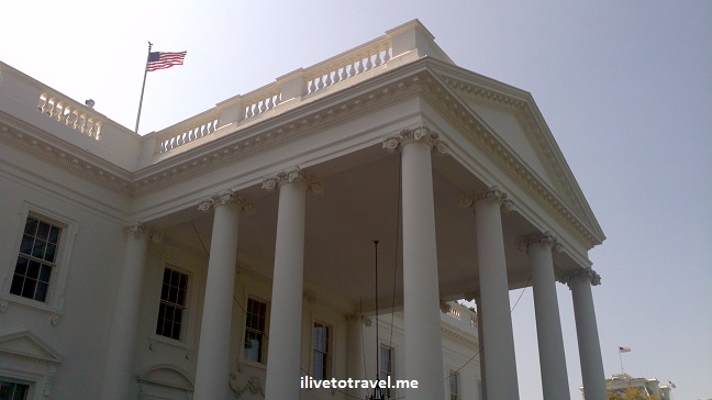
The Power Capitals: Washington, D.C., Beijing and London

When I was a kid (some would argue I am still one), I was fascinated with knowing capital cities and flags.  Not really sure why, perhaps it was an early predictor of future sanity.  I was pondering the other day that there are countries that I have visited whose capital cities I have not than I thought.  So I started thinking which capital cities have I visited and could there be some common thread to some of them.  That led me to think of a new series to briefly chat about the capital cities I have visited.

White House, Washington D.C., DC, center of power, President's residence, US flag, photo

The White House, literally and/or figuratively, the world’s center of power

In this group, I’d thought I’d include some capitals that represent power centers.  While I could add a few others, those fit better within future categories I will be sharing.  For this post of power centers, I have chosen to include:  Beijing, Washington, D.C., and London.

Entrance to the Forbidden City Beijing, China bicycles cars pollution

Entrance to the Forbidden City in Beijing just north of Tiananmen Square

These are certainly global power centers for financial and political reasons.  But they could not be any more different from each other.  The following statements, of course, are up for discussion and challenge but they sort of indicate how I “feel” these power centers:

  • Whereas London exudes history, D.C. has it but as a secondary or tertiary theme to its power center persona, whereas Beijing seems hell-bent on destroying its fascinating history.
  • Whereas Beijing is exotic to me, D.C. exudes a vibrancy that is uncommon for me and that thrills me, and London exhibits a self-assured calm that almost makes it familiar, yet not exotic nor vibrant.
  • While London feels cozy as you spend time in its neighborhoods (despite its incredible size), Beijing feels large and cold.  And D.C. … well at times it feels just like a large political amusement park until you explore what’s behind “public D.C.”.
  • All three can feel impersonal, but I think once you get to know London and D.C.  that changes with the only difference being that D.C. seems more transient than London does, making London more of a place where one can grow deep roots.

Where I would live?  I would say D.C. hands down.  In fact, in any list, this would be on my top three places to live.  I feel the energy and it transcends the political activity-related energy.  I love walking the treed streets of the city, admiring architecture new and old, and discovering places to hang out (London does offer some of this.)

Where I would learn the most?  I would say Beijing with its long history and fascinating culture.

Where I felt people warmth?  London would have an edge on D.C. but, in reality, none, I’d venture say, excel at people warmth.  Not sure if that is related to the power center nature of the city, the culture of the country/city, or some other factor (like it just takes time to feel it).

Any big gripe on any of these?  The pollution in Beijing is about the worst I’ve experienced.  I got sick from it, putting a big damper on my time there.  And no “nearby Rio de Janeiro” (as Sao Paulo has) for me to go “heal.”  🙂

Where would I love to return?  Sure, I’d enjoy going back to London but D.C. would be it.  Beijing… Been there, done that.  I’d rather learn about China through other places.

The City, London, England, United Kingdom, power center, capital city, financial center

London is a power center, especially in global finance

Of course, different strokes for different folks – what’s delicious to me may be bland to another so take it all with a grain of salt and share your impressions of any of these cities if you have visited them!  Regardless, these are fascinating cities to explore.

Photo of the Week – Color in a Bowl

While not a big shopper here, sometimes I do stop to take a look at the arts and crafts made in the places I visit – usually hoping that something unusual catches my eye:  either for a purchase or a picture.  During my trip to Jordan I stopped at a store that had plenty to grab my attention.  Here is one of my favorite finds (nope, I did not purchase it; no space!).

color, bowl, arts and crats, Jordan, shopping, ceramic, travel, photo, Canon EOS Rebel, souvenir

Colorful bowl made in Jordan

The Walls of the Wadi Mujib

The Wadi Mujib in Jordan is a fun place because you get to explore a gully (“wadi”) in which water is flowing.  The first part of the Wadi is maybe ankle deep or a little higher in some places so pretty easy and fun (though I kept worrying I would drop my camera in the water!).  It is also a refreshing way to spend part of the day as you are generally out of the sun and the water feels good!

Wadi Mujib, Jordan, outdoors, adventure, fun, Middle East, colors, travel, photo, Olympus

The entrance to the wadi

Wadi Mujib, Jordan, outdoors, adventure, fun, Middle East, colors, travel, photo, OlympusWadi Mujib, Jordan, outdoors, adventure, fun, Middle East, colors, travel, photo, OlympusWadi Mujib, Jordan, outdoors, adventure, fun, Middle East, colors, travel, photo, Olympus

My favorite part of exploring the Wadi Mujib is to see those colorful walls up close.  I walked with no rush and soaked in the view all around me.  For the more intrepid, go deeper into the canyon where a true adventure awaits (don’t bring your camera unless it is waterproof!).Wadi Mujib, Jordan, outdoors, adventure, fun, Middle East, colors, travel, photo, Olympus Wadi Mujib, Jordan, outdoors, adventure, fun, Middle East, colors, travel, photo, Olympus Wadi Mujib, Jordan, outdoors, adventure, fun, Middle East, colors, travel, photo, Olympus Wadi Mujib, Jordan, outdoors, adventure, fun, Middle East, colors, travel, photo, Olympus

And if you are tired of walking, just ride your way out!Wadi Mujib, Jordan, outdoors, adventure, fun, Middle East, travel, photo, Olympus

If you go to Jordan, don’t miss this neat outdoor experience!

%d bloggers like this: