Checking out Cloudland Canyon State Park

On a very cold fall morning (actually, late morning as it was 11:45AM) I started what would be a super cool hike in Cloudland Canyon State Park in NW Georgia. NW as in the true corner of Georgia where it meets Alabama and Tennessee, in the Cumberland Plateau. A friend selected this state park, two hours’ drive away from Atlanta, for our Sunday hike. Excellent choice!

The state park offers several trails but the most epic one is the one that allows the hiker to properly appreciate the Cloudland Canyon: the West Rim Loop Trail. Oh, and worth noting the park offers fishing, horseback riding trails, picnicking and the like. For those not hard-core hikers, the Overlook Trail offers a way to see some of the beauty.

cloudland canyon state park, hiking, north Georgia, outdoors, nature, fitness
Approaching the trails from the parking lot

The West Rim Loop Trail

The trail actually starts with an in-and-out section that is about 1-mile+ long that crosses Daniel Creek. It is worth noting (and expressing gratitude!) that this state park is so well prepared for us hikers. It has excellent, readable signage (Iowa State University is a sponsor or supporter of these – thank you!) and very reliable trail markers (yellow for the West Rim Loop Trail).

There are some magnificent rock formations of different sorts, which are also seen further south in the trails of north Atlanta.  Certainly, one can envision how the natives in the area used those formations for their shelter.
Yellow marks the way!

Also, there are many well-prepared lookouts, many with very good and sturdy railings, and some vantage points just left open as nature set them up!

cloudland canyon state park, hiking, north Georgia, outdoors, nature, fitness
One of the many vantage points
There are some magnificent rock formations of different sorts, which are also seen further south in the trails of north Atlanta.  Certainly, one can envision how the natives in the area used those formations for their shelter.

At the end of it (35 minutes later), it meets up with the loop part of the trail, about a 2-mile hike reaching about 1,900 ft altitude. We completely guesses which way to go once we got to the loop and we opted to go left.

Good choice. Though it starts with a long uphill, the left side offered a great view over a plain-like area and a town that I believe was Trenton, Georgia. At some point, the loop hit a rocky promontory sort halfway through and then the trail turned to face to east rim and rockface of the Cloudland Canyon.

Checking out rock formations

There are some magnificent rock formations of different sorts, which are also seen further south in the trails of north Atlanta.

cloudland canyon state park, hiking, north Georgia, outdoors, nature, fitness

Certainly, one can envision how the natives in the area used those formations for their shelter.

hiking, rock formations, north Georgia, nature, outdoors, ilivetotravel
Not my home but in a bind…

The walls of a grand canyon

Wow! What a spectacular and long canyon-face! Certainly that was the part to see after passing the mid-point of the loop! One is rewarded with many lookouts (in-and-out very short trails) to enjoy the view.

cloudland canyon, georgia state park, nature, outdoors, hiking

Overall, the West Rim Loop Trail is 5 miles long. It took us 3 hours with the stops we made on the lookouts, random photos and snack/water breaks. There were other hikers but far from “crowded”.

One neat thing is that there are yurts and cabins in this trail. I think it would be awesome to do an overnight or two and see the scenery at different times of day.

Oh, and there’s more! Waterfalls!

Once we finished the trail, we went to see Cherokee Falls which is near the entrance to the trail. It is a spectacular climb down stairs (with the subsequent climb back up!) to get to it. The path that is not a staircase is much easier to handle!

cloudland canyon state park, hiking, north Georgia, outdoors, nature, fitness

One passes a MASSIVE boulder hanging over the trail (with a bench under it).

cloudland canyon state park, hiking, north Georgia, outdoors, nature, fitness
Don’t linger long under it!

The waterfall setting is well worth the trouble as were those at Panther Creek, another rewarding hike to a waterfall in north Georgia. My knees were a little sore when we finished the loop trail but, boy, did I make the right choice going down to see the waterfalls! The roundtrip to see the waterfall was a mile. Another mile roundtrip would have taken us to a downstream waterfall, Hemlock Falls. But, at 6 miles and my knees, I was glad to leave that for a future visit!

cloudland canyon state park, hiking, north Georgia, outdoors, nature, fitness
This is the reward – a spectacular spot!

If I were to return, besides trying to stay overnight at a yurt or cabin, I would certainly do it a little earlier in the fall because the color change of the trees would only add another level of spectacular to what is already a spectacular setting!

Hike to an Inn in North Georgia

If you are a casual reader of this blog, you will know that I enjoy hiking near and far from my home.  One of the “near” hikes on my list to check out was the hike to the Hike Inn in north Georgia.  The Hike Inn can only be accessed by hiking to it hence the name (actually, it’s full name is Len Foote Hike Inn).  There is a service road leading to it but, as the name implies, it is for service, not for guests.  Guests need to do the 5 hour hike in and out.

The trail begins atop Amicalola Falls (about 1.5 hrs/70-mile drive from Atlanta) – a destination to check out onto itself with other trails and a phenomenally tall set of staircases if you want to walk from the bottom of the falls to the top.  On this day, we drove to the top of the falls where we would leave our vehicles.

Amicalola, falls, Hike Inn, Georgia, Atlanta, hike inn, hiking, outddors, nature, photos

The top of Amicalola Falls – awesome place!

Amicalola, falls, Hike Inn, Georgia, Atlanta, hike inn, hiking, outddors, nature, photo, trailhead

The start of the Hike Inn trail

The Hike Inn is in high demand so you need to book it in advance.  It is well worth it.  The hike is not super strenuous and you are rewarded by a magnificent place to stay.

Georgia, Atlanta, hike inn, hiking, outddors, nature, photos

Amazing detail of nature

Georgia, Atlanta, hike inn, hiking, outddors, nature, photo

Along the trail

Georgia, Atlanta, hike inn, hiking, outddors, nature, photo

Our arrival at the Hike Inn!

Georgia, Atlanta, hike inn, hiking, outddors, nature, photo, sky

The view from the Hike Inn – magnificent

The accommodations are basic (bunk beds) and you can get private rooms.  The bathrooms and showers are shared but they are actually quite clean and nice (especially when compared with how basic the rooms are).  The toilets actually do not flush but, instead, deposit the waste (nice wording, huh?) somewhere below where it is taken advantage of through processes that they staff will happily explain if you decide to take them up on the tour of the facility (it is actually worth doing).

Georgia, Atlanta, hike inn, hiking, outddors, nature, photo

Hallway by the rooms

Georgia, Atlanta, hike inn, hiking, outddors, nature, photo

Bath house building

Georgia, Atlanta, hike inn, hiking, outddors, nature, photo, toilet

There are rules for the toilet

Actually, everything about the place is about taking care of the environment.  The inn offers dining service with support of volunteers who get to stay for free for their service.  The Hike Inn politely stresses the importance of not wasting food (only serve yourself what you need) and actually tracks clean plates’ count at the end of a meal.  The food is delicious and the dining area is an open space where you can meet other hikers.  Really neat.

Georgia, Atlanta, hike inn, hiking, outddors, nature, photo, lodge

Dining area

Georgia, Atlanta, hike inn, hiking, outddors, nature, photo, menu

Menu of the day

Georgia, Atlanta, hike inn, hiking, outddors, nature, photo

Chart showing how well diners have done

After dinner (or before), you can sit and relax in any number of places around the inn.  One of my favorites is the upper porch looking east-ish – I love me a good rocking chair with a view!  You can also go for short walks around.  Right in that upper porch area is a game room where people can congregate and play games or read a book.

Georgia, Atlanta, hike inn, hiking, outddors, nature, photo, lodge

The living/game room

The best part of it all is sunrise.  If you wake up early enough (and I recommend it!), go down to the sitting area below and face east.  Bring a blanket.  And then enjoy a majestic sunrise if the weather cooperates.  It is the perfect way to end the stay before starting back on the trail down.  Next time I go, I think I may stay two nights to really enjoy the place and its surroundings!  I leave you with a series of photos from the amazing sunrise I witnessed!

Georgia, Atlanta, hike inn, hiking, outddors, nature, photo, sunrise, sunGeorgia, Atlanta, hike inn, hiking, outddors, nature, photo, sunrise, sunGeorgia, Atlanta, hike inn, hiking, outddors, nature, photo, sunrise, sunGeorgia, Atlanta, hike inn, hiking, outddors, nature, photo, sunrise, sunGeorgia, Atlanta, hike inn, hiking, outddors, nature, photo, sunrise, sun
Save

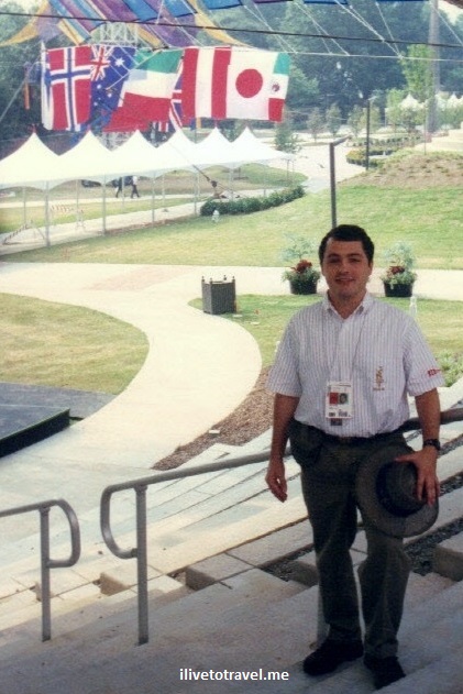
Volunteering at the 1996 Atlanta Olympics

I shared earlier, as a lead-in to the celebration of the 20th anniversary of the Atlanta Olympics, how I was involved as a college student in the efforts to win the rights to host the 1996 Olympic Games in Atlanta.  Once again, though not exactly a travel topic, I use my blog to share my experiences related to the 1996 Olympics.  In this installment, I will talk about my experience in preparation for and during the Games.

Atlanta, Olympics, 1996 Games, volunteer, Georgia Tech, photo, flags

ilivetotravel in full Envoy uniform

Becoming an Olympic volunteer

Let’s rewind to around 1994, when I was informed about a role that was going to be seeking volunteers for the 1996 Olympics in Atlanta and that I should apply as a natural follow-on to my involvement in the efforts to win the Games.  The role was called Envoy and there would be one per participating delegation.  The purpose of the role was to be the liaison between the Organizing Committee and the particular country’s delegation focusing on the relationship with the head of the delegation, or Chef de Mission as they are called in Olympic lingo.

I interviewed and was named to be the Envoy for Chile, perhaps because having found no candidate from that country, I was next best since I had lived there for 3 months a few years before (and, of course, I spoke the language).  The requirement for the role was that we would attend weekly meetings from 1994 to 1996 and that we would be full-time available a total of 6 weeks before and during the Games.  My employer at the time (Andersen Consulting) allowed me to use up my vacation to cover these six weeks and, when my vacation bank ran out, they graciously offered me 50% of my pay as their way to show support for my involvement and I took the rest of the time without pay.  More importantly, my employer allowed me to be staffed in an intown project (vs. traveling every week which I had been doing for almost 3 years up to that point) so I could participate in the weekly meeting which took place Tuesday nights.

Two years learning about the Olympics

The weekly meeting for two years was required as there was a lot to learn.  From the processes the delegations would have to deal with (registration, arrival, drug testing, ordering box lunches for training sessions, and on and on) to the sports venues, the sports themselves, the workings of all aspects of the organizing of the Games, etc.  Every week for two years close to 200  of us gathered at the Georgia Tech electrical engineering building auditorium (where I sat many times during my college years!!) for these sessions.  We, the folks who represented Latin American countries tended to cluster together and have a blast during all this.  A couple of others joined us because they also were fun though they did not represent Latin American countries (the envoys for France and Canada come to mind!).

It was fascinating to understand the workings of this complex endeavor.  And, as we reported to the Olympic Village organization, it was fascinating to understand how you launch a small town of 20,000 for a 6-week life span (delegations can arrive as early as two weeks before the start of the Olympic Games, hence why we had to be available for more than the duration of the Games).  Many Georgia Tech dorms and frat houses were refurbished, new mattresses were brought in, and the security zones and mechanisms had to be installed.  Delegations were strategically scattered around the campus based on many factors like delegation size, threat levels they could have (think the Israeli delegation… also of note, Iran was placed right by the highway – no threat likely to them!), and proximity with like or unlike countries (big Latin –read, party- countries were placed together in an area north of campus separate from the rest; think Italy, Spain, etc.), etc.

The Atlanta Olympic Village at Georgia Tech

The Village was a phenomenal place.  It had a zone open for visitors who got invited by delegations or Village officials.  This included the main cafeteria.  And then it had a higher security zone with restricted access to the residential part of the Village and other more private areas for the athletes and officials.  Envoys got to stay in the residential part of the Village too so we could be close to our delegations if need be.  We probably got the worst spots.  Ours was a frat house that, while I am sure had been cleaned up some, was still a little on the not-nice side so I opted to stay home and just deal with waking up super earlier to make our daily 6AM meeting.

Atlanta, Olympics, 1996 Games, volunteer, Georgia Tech, photo

The frat house where I was able to stay at the Village

Georgia Tech, Olympic Village, Chile delegation, photo

My delegation’s house and my Chef de Mission on the left

We did get to dine with athletes at a number of facilities around the Village.  There happened to be a McDonald’s tent right behind my delegation’s house.  You could smell the hundreds or thousands of burgers cooking!  And athletes from other countries, especially those without any or many McDonald’s, absolutely loved it.  Not sure there coaches did…  The main cafeteria was great.  I ran into a few famous people whether athletes, coaches, or visiting VIPs.  Two that stand out were Dolph Lundgren (who was there as a coach and who SO patiently stop his meal to get up to have his picture taken with athletes), and the Queen of Spain.  Towards the end of the Games, my delegation let me have two of their limited guest passes so I could have my Mom and stepdad come visit and eat at the Village.  To his last days with the use of his memory, my stepdad so enjoyed telling people about the time when he ate at an Olympic Village – I was so blessed to be able to give them the opportunity to be at the Village!

Atlanta, Olympics, 1996 Games, volunteer, Georgia Tech, photo, cafeteria

My wonderful Mom and I at the main cafeteria at the Village

Atlanta, Olympics, 1996 Games, volunteer, Georgia Tech, photo, cafeteria

Meal tickets for the cafeteria

My job as an Envoy

I had a small team working with me as my delegation was not big but it was not tiny.  There were to associate envoys and two drivers in the team.  One of the neatest things about this was that I got to invite two good friends to apply for these positions and work together during the Olympics!

My day to day work was to be of service to the Chef de Mission and accompany him wherever he needed to go.  (In reality, his number two really ran the delegation so I supported the delegation through him but I spent more time accompanying the Chef de Mission around).  Because of this requirement of the role, that meant we had to have the same access as the head of the delegation which gave me access to any space, seating area, etc. in the Olympics.  There was only one place he could go that I could not:  the field of play (being the boxing ring, the basketball court, or the area immediately around a swimming pool).  But these access rights allowed to sit in the area reserved for officials if I wanted to watch an event.  As long as a delegation official did not need a seat, I could take it.  Often I was with him but sometimes when he didn’t need me, I took advantage of this to watch some event or another.  It was cool.  I saw quite a few good and important events!

Atlanta, Olympics, 1996 Games, volunteer, handball

Medal ceremony for men’s handball

Arantxa Sanchez-Vicario, tennis, Atlanta, 1996 Olympics, Olympic Games, photo

Arantxa Sanchez-Vicario playing

Eraser, Arnold Schwarzenegger, premiere, 1996, Atlanta, Olympics, Olympic Games, Georgia Tech

The premiere of Schwarzenegger’s Erase was held at the Olympic Village!

The Atlanta Opening and Closing Ceremonies

One super neat privilege this role gave me was the ability to go to the Opening and Closing Ceremonies without having to buy a ticket as I was expected to accompany the delegation to those events.  For the Opening Ceremonies the delegations were sat in an old stadium neighboring the Olympic Stadium (Fulton County Stadium which was demolished after the Olympics were over).  There they awaited the start of the Parade of Nations when they would walk into the Olympic Stadium and then stand in the field for the rest of the ceremony.  I sat with the Chilean delegation as they waited their turn.  Someone missed cuing the delegations in a timely manner at the start of the process and we ended up having to run between the two stadia to get them there on time.  This was a scary moment as our Chef de Mission was in his 70s and not necessarily fit.  It was a bit terrifying but we made it. At the point they would enter the stadium, the Envoys broke away and ran through inside tunnels to then re-join the delegation for the last third of their march.  I am not fully clear why we were not allowed to just march with them the whole way but I am grateful we were allowed to do some of the march as it was an experience to march in the Opening Ceremonies of an Olympic Games!

Atlanta, Olympics, Opening Ceremonies, Olympic Games, 1996, Parade of Nations, pass, defile des delegations, Olimpiadas

The pass that allowed me to march with a delegation!

One of my biggest regrets is that I did not lug my camera around all over with me.  Things were too busy and these were days far from smartphones and social media so you did not feel the need to capture every moment of life – back then we just LIVED life.  I ran into famous people (royalty, politicians, famous athletes, etc.) but there are no pictures.  I got one photo of me in the Opening Ceremonies thanks to the envoy to Ghana who had a disposable camera at the Opening Ceremonies and graciously took my photo!

Atlanta, Olympics, 1996 Games, volunteer, Opening Ceremonies, cauldron

Clearly not the best quality but my only photo at the Opening

The Opening Ceremonies took place on a hot day (July in Atlanta…) and that evening it was hot and humid especially in the field in the stadium where there was less chance of a breeze.  Having all these people stand waiting for a couple of hours or more was a bit like torture.  I kept myself busy trading pins (my delegation had given me, like they do every member of their delegation, a bag of Chilean pins so I could trade!), taking in the entertainment, etc.  Sadly, an official in the Polish delegation had a heart attack during the Ceremonies and would die from it due to the stress to his body that night.  Olympics since have gone ahead and provided seating so the delegations do not have to endure this two hours or more of standing – it was highly inconsiderate to have required them to stand in 1996 and earlier especially since the athletes will be competing in a few days after the Ceremonies (the ones who would compete the next day seemed to skip that night so they could be well rested).  I presume they did not give them seating before so they could sell more tickets to the public (the dirty little secret is how much a business the Olympics really are and even corrupt as later events would reveal about members of the International Olympic Committee – a pseudo-royalty who lives in a world of perks and political intrigue…).

Atlanta, Olympics, 1996 Games, volunteer, Closing Ceremonies, Gloria Estefan

Me awaiting the start of the Closing Ceremonies! (the one waving!)

Anyway, the Closing Ceremonies were a different affair because seating was planned for the delegations.  Of course, as soon as the opportunity arose (when the official business of closing the Games and passing the flag to the next host finished and the musical part of the show began), many delegations jumped “the fence” and got into the field to dance and enjoy themselves.  Go figure!  I did not miss a beat and followed my delegation though I pretty quickly lost them in the mayhem in the field.  It was a fun time and we had some disposable cameras this time which allowed us to take a few shots to remember the night by.  I recorded the Opening and Closing Ceremonies at home and watching the recording of the Closing Ceremonies always makes me smile.

Atlanta, Olympics, 1996 Games, volunteer, Closing Ceremonies,

Partying during the Closing Ceremonies in midfield!

Atlanta, Olympics, 1996 Games, volunteer, Closing Ceremonies, Gloria Estefan

Gloria Estefan performed at the Closing Ceremonies

Atlanta, Olympics, 1996 Games, volunteer, Closing Ceremonies, Gloria Estefan

Bringing down the Olympic flag during Closing Ceremonies

Remembering the entire experience makes me smile.  To me the Atlanta Olympics were nothing like the negative image portrayed.  Everything worked as well as any city can with tons of visitors.  The spirit of Atlantans was evident in the welcoming attitude, the staying away from driving as much to minimize traffic, and the incredible number of people who served as volunteers in every possible job imaginable.  I was and am proud of my city.  The Olympics may be a weird animal but it certainly allows the world to come together and change the conversation for two weeks every two years.  I am glad I got to see it from the inside and have the experiences I did!

Atlanta, Olympics, 1996 Games, volunteer, Envoy

With some of my favorite people (but not all!) from my time as an Envoy


Save

Save

Save

Save

Chattahoochee River Hikes: Vickery Creek Trail in Roswell

Right by old town Roswell, a few miles outside of Atlanta‘s “perimeter” (an interstate highway that rings the city), is the Vickery Creek Trail.  There are about 7 miles worth of trails in this pocket of nature in the middle of Roswell.  A portion of the trails are near the creek (also named Big Creek) which hits the Chattahoochee River right by the entrance to the parking lot I used to hit the trailhead.  This area is also part of the Chattahoochee River National Recreation Area, a collection of parks along the river which crosses Atlanta from the NE to the SW (sort of!).Vickery Creek, Roswell, Georgia, Chattahoochee, river, park, Atlanta, hiking, outdoors, nature, trail, Samsung Galaxy S7, photoVickery Creek, Roswell, Georgia, Chattahoochee, river, park, Atlanta, hiking, outdoors, nature, trail, Samsung Galaxy S7, photo

The trail offers moderate hiking, with some fairly flat portions and a few climbs that I would guess are not too strenuous to the average person.  The trails are well marked (the blue square spray painted on trees) and well signed so one can make one’s way around pretty easily.  Because of the time of the year, what seemed to me to be mountain azaleas were in bloom (pinkish flowers). Vickery Creek, Roswell, Georgia, Chattahoochee, river, park, Atlanta, hiking, outdoors, nature, trail, Samsung Galaxy S7, photo Vickery Creek, Roswell, Georgia, Chattahoochee, river, park, Atlanta, hiking, outdoors, nature, trail, Samsung Galaxy S7, photoVickery Creek, Roswell, Georgia, Chattahoochee, river, park, Atlanta, hiking, outdoors, nature, trail, Samsung Galaxy S7, photoVickery Creek, Roswell, Georgia, Chattahoochee, river, park, Atlanta, hiking, outdoors, nature, trail, Samsung Galaxy S7, photoVickery Creek, Roswell, Georgia, Chattahoochee, river, park, Atlanta, hiking, outdoors, nature, trail, Samsung Galaxy S7, photoflowers, Vickery Creek, Roswell, Georgia, Chattahoochee, river, park, Atlanta, hiking, outdoors, nature, trail, Samsung Galaxy S7, photo
What is cool about this trail is seeing the two waterfalls created by a small and a large dam.  The area around the larger waterfall is not large and one has to watch one’s step but it is a pretty spot.Vickery Creek, Roswell, Georgia, Chattahoochee, river, park, Atlanta, hiking, outdoors, nature, trail, Samsung Galaxy S7, photo, waterfall Vickery Creek, Roswell, Georgia, Chattahoochee, river, park, Atlanta, hiking, outdoors, nature, trail, Samsung Galaxy S7, photo, waterfall Vickery Creek, Roswell, Georgia, Chattahoochee, river, park, Atlanta, hiking, outdoors, nature, trail, Samsung Galaxy S7, photo, waterfall Vickery Creek, Roswell, Georgia, Chattahoochee, river, park, Atlanta, hiking, outdoors, nature, trail, Samsung Galaxy S7, photo, waterfall

There are also a covered bridge and a large span bridge further down which facilitate cross the creek to other trailheads and parking areas.   Whether you are here in Atlanta to go up to the mountains or just visiting the city, this trail is one of many easy to visit and yet offering a unique hiking experience!

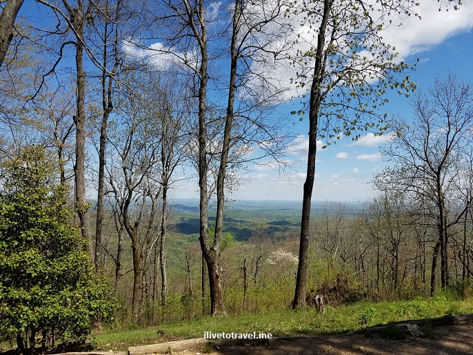
How Can You See Atlanta’s Carpet of Green? Pine Mountain!

Atlanta is known for its crazy traffic and challenging airport.  But it is also known for the carpet of green that covers the city far and wide.  A week ago (or so), I was looking for a new hike not too far from the city and new to me.  Thankfully, we are not lacking for good hikes within 30 mins of the city (and if you expand that to 1.5 hrs, the possibilities are endless it seems!).

I opted to go north on I-75 to climb Pine Mountain in Cartersville.  The 4.6 round-trip hike was of moderate difficulty and not heavily trafficked.  When I arrived around 9:45 AM, the small parking lot of Main St. (not even a quarter mile from I-75) was pretty full.Atlanta, hiking, Georgia, mountains, nature, outdoors

The trail has a West Loop and an East Loop connected by a pass where the summit is found.  We hiked the southern end of both loops and the returned via the northern loops.  It was beautiful terrain and, with trees still not fully covered with leaves, one could see much further around which is one of the things I enjoy about hiking in colder weather.

hiking, map, Pine Mountain, Georgia, outdoors, nature, photo, Atlanta

Trail Map

What I enjoyed about this hike, beyond its accessibility for this city dweller was that it offered a great view of the carpet of green that is the greater Atlanta metro area.  In the distance I could see the faint skyline of downtown, Midtown, Buckhead and Sandy Springs with Lake Allatoona in the foreground.  I have to say, this was a neat hike easily fitting in a half day.  I leave you with pictures from the hike and the view though the skyline is too small for it to show well on the photos so may not even see in these photos.  Beware:  a lot that looks like just green forests actually hides neighborhood after neighborhood in greater Atlanta!

Atlanta, hiking, Georgia, mountains, nature, outdoors, creek, trees, forest

Atlanta, mountains, hiking, Kennesaw, Marietta, view, forest

The double hump mountain is Kennesaw Mountain, a famous Civil War battlefield

Atlanta, hiking, Georgia, mountains, nature, outdoors

Of course, the highway (I-75) is not too far away!

Atlanta, hiking, Georgia, mountains, nature, outdoors, bridge, forest, trees Atlanta, hiking, Georgia, mountains, nature, outdoors Atlanta, hiking, Georgia, mountains, nature, outdoors, creek, trees, forest Atlanta, hiking, Georgia, mountains, nature, outdoors, creek, trees, forest Atlanta, hiking, Georgia, mountains, nature, outdoors, creek, trees, forest

Atlanta, hiking, Georgia, mountains, nature, outdoors, creek, trees, forest

Lake Allatoona

Atlanta, hiking, Georgia, mountains, nature, outdoors, creek, trees, forest

In-and-Out: Brunswick in Coastal Georgia

While many of my travels allow me to spend time in a city or country for a long enough time, sometimes that is not the case.  And that is usually when I go on business trips.  It has been quite common for me to travel for long periods of time with work but, especially in the case of domestic travel, trips can be quite short.  That means either the ability to explore is limited to off work hours or to just one evening.  In the spirit of still sharing what I see, it makes sense to do an “in-and-out” series where I can share the small windows I get to see a place with you.  My hope is that it may show glimpses of places, however limited in scope.  So here goes the inaugural post – and please let me know if you like the idea.

Coastal Georgia – Historical… at least for Georgia

The state of Georgia does have a coastline, on the east along the Atlantic Ocean.  That coast is dotted with many islands like Jekyll, Cumberland, St. Simons, etc.  South of the middle of that coastline is the town and port of Brunswick.  Now, I know it may not be much to be excited about given Boston, Philly, Paris, London or Athens but in this part of the Southeast, Brunswick goes “far” back as 1738, depending on how you count.  Supposedly, around that time, the British set up something in the peninsula where Brunswick sits to almost face the Spanish who were in nearby Florida (credit Oglethorpe) AND who had laid claim to lands in this area too (the boundary between modern-day Florida and Georgia not existing back then). In the end, it is funny to think about that this all would have ended up being Florida has the Brits not initially colonized the area…  Brunswick as a town did not get founded until the 1850s but still, its history goes back to colonial times and that fascinates me.  It was designed, though, in the late 18th century in a layout similar to Savannah with many squares (14 of them, large and small) almost mathematically laid out in a grid of streets.

Brunswick, Georgia, parks, squares, layout, map

Map of downtown and its squares and parks

Brunswick, Georgia, parks, squares, layout, map

One of the smallest squares

Downtown , square, Hanover, Brunswick, Georgia

One of the larger squares: Hanover Square

I wonder if Savannah won some battle against Brunswick to become the premier coastal Georgia city.  Brunswick certainly is gifted in terms of its setting.  Perhaps Savannah had some edge with the river and better fit for a port?  But Brunswick was a very important port in the shipping of lumber abroad.  England, Cuba and Brazil were among the destinations for lumber that made it out of the continental U.S. through this port.  It is also incredible to learn that the largest blimp base during WW II was located in Brunswick since there was threat of German U-boats along the southeastern U.S. coast.

Approaching Brunswick – Golden Isles Airport

I had a choice to drive for 5 hours or take a short flight.  Because of the short duration of the visit, a 10-hr round-trip did not make sense.  Now, if the plane had been a larger plane, the flight may have been 30 minutes but it took about 50.  That’s OK.  On my flight in, I got some good views of the land around, with rivers or creeks and perhaps marshes.  I never got to see the ocean as the approach did not require to go past Brunswick towards St. Simons and a turn back.

Brunswick, Georgia, coast, window view, airplane, travel, South, trees, final approach

Lots of tree farms near Brunswick

Brunswick, Georgia, coast, window view, airplane, travel, South, trees, river, final approach Brunswick, Georgia, coast, window view, airplane, travel, South, trees, river, final approach  Brunswick, Georgia, coast, window view, airplane, travel, South, trees, river, final approach Downtown Brunswick

I did not have much time in the area and, because of closing hours, I could not visit places like Fort Frederica.  But I decided to, at least, make the short drive from my hotel near the tiny airport to the downtown area.  The town proper is quite small but it was very charming.   And the time of day for visiting, right before sunset was just perfect for the best light.downtown, Brunswick, Georgia, red brick, architecture, charming, photos, downtown, Brunswick, Georgia, red brick, architecture, charming, photos, Coca-Coladowntown, Brunswick, Georgia, red brick, architecture, charming, photos downtown, Brunswick, Georgia, red brick, architecture, charming, photos, Ritz downtown, Brunswick, Georgia, red brick, architecture, charming, photos downtown, Brunswick, Georgia, red brick, architecture, charming, photos, sunset downtown, Brunswick, Georgia, red brick, architecture, charming, photos, rainbow, flag

Old homes in downtown Brunswick

I loved seeing old homes not immaculately restored but kept up.  Clearly, Brunswick is not a ‘happening’ place that pulls visitors in left and right but that, perhaps, has kept it more authentic or reflective of how places ‘used to be’ since it is not corrupted by out-of-control development nor by anti-septic ordinances that force artificial curbs, sidewalks, etc.

Brunswick, Georgia, coastal, town, architecture, Oglethorpe, charming, photo, southeast Brunswick, Georgia, coastal, town, architecture, Oglethorpe, charming, photo, southeast Brunswick, Georgia, coastal, town, architecture, Oglethorpe, charming, photo, southeast Brunswick, Georgia, coastal, town, architecture, Oglethorpe, charming, photo, southeast Brunswick, Georgia, coastal, town, architecture, Oglethorpe, charming, photo, southeast  Brunswick, Georgia, coastal, town, architecture, Oglethorpe, charming, photo, southeast Brunswick, Georgia, coastal, town, architecture, Oglethorpe, charming, photo, southeast Brunswick, Georgia, coastal, town, architecture, Oglethorpe, charming, photo, southeast Brunswick, Georgia, coastal, town, architecture, Oglethorpe, charming, photo, southeastCoastal sunset in Georgia

The skies were a little dark because it had just rained.  You may appreciate in a couple of photos the rainbow coming out.  But the best was left for my drive out of Brunswick:  a beautiful sunset as a backdrop.

Brunswick, Georgia, sunset, sun, cloud, silhouette, golden, sky, photo Brunswick, Georgia, sunset, sun, cloud, silhouette, golden, sky, photo

Hiking Tips from an Unexpected Climb of Blood Mountain

I enjoy hiking and love exploring new routes.  On one recent hike, near my home in Atlanta, I had the opportunity to learn some lessons in hiking so I’d thought I’d share some hiking tips from that experience.  While these tips may be common sense, the refresher is always good…  But before I share the hiking tips (located at the end of the post), let me tell you what happened…

The setup to the story

Living in Atlanta, Georgia I have access to great hiking an hour and a half away from the city at the southern end of the Appalachian Mountains, host of the famous Appalachian Trail (AT) that runs from north Georgia all the way to Maine.  There is nice hiking closer to Atlanta (like around the Chattahooche River National Park) but for longer and more strenuous hikes (and overall better vistas), I like going up to the north Georgia mountains despite the trip adding a 3-hour round trip to and from the mountains.

I was looking for a long hike to do on a daytrip as part of general conditioning for my hike in Patagonia and I was seeking a loop, instead of an in-and-out hike.  A good friend who also enjoys hiking offered to come along (I don’t hike solo) and we set out to do Jarrard Gap Trail connecting it to the Slaughter Creek Trail by traversing a 1.85 mile stretch of the AT for a total hike of around 5.75 miles.  It was a great hike but I learned some lessons in hiking from an unexpected twist in our hike…

While I have hiked in interesting places (like the Transylvanian Alps in Romania and Mt. Kilimanjaro), I am not an expert hiker who knows all the tricks of the trade, who is used to half-missing signage, who is secure in his inner compass, etc.  So I rely on maps and stuff I find on the Internet to create a route.  (My friend Val in Real Life would probably laugh her rear off at my lack of innate outdoor skills!)  On this occasion, my friend and I got a little complacent thinking we had clear in our head the route we were taking.  I will first share with you the hike we DID as it was definitely diverse in terrain and views, and enjoyable, if long.  I will then tell you what we THOUGHT we were going to do that day and highlight the difference between the two.  And then, I will share some lessons I learned!

The innocent start to the hike

After driving about 1.5 hrs, we arrived at Winfield Scott Lake, a rather small lake at the start of our hike.  To get there, we passed the entrance where visitors are supposed to take an envelope and place $5 in it and drop it in a locked box.  One is supposed to tear off part of the envelope and hang it on the rear view mirror of the vehicle (the number on that stub and the envelop in the locked box would match, telling the part ranger that this car has paid).  There were no envelopes to be found so we improvised and dropped the fee with a label that indicated my license plate in case someone checked.  We doubted anyone would be checking on this Sunday but we preferred being good citizens.  I took a picture of what I dropped in in case I needed it later to fight a citation!dollars

The actual hiked route

We entered the trail and, after crossing a narrow and single-side handrail bridge, we were dumped on a paved road where we saw a house with Halloween decorations still on the mailbox (this would prove useful later!).  There was a simple sign indicating the way and we walked maybe 0.25 miles on the road until the real entrance to the real Jarrard Gap Trail.

Appalachian Trail, north Georgia mountains, hiking, trail, Jarrard Gap, photos

On the Jarrard Gap Trail

The terrain was a nice upward slope but not too intense.  Nice views of the downhill on this winter day.  Once we exited this trail at the Jarrard Gap, we walked a little to the next set of signs which helped point the way in this 4-way intersection.  Except it was not all too clear as it did not have any of the names in our map.

Someone told us which way was the AT and we walked little on it until we saw the white mark that is used to mark the AT so on we went.  So we entered the AT in the direction of Blood Mountain.  There were slight (rolling, I would call them) downhills and flat bits of terrain.  We passed a camp area on the left after having taken a quick break, and soon on the right we saw the trailhead to the Freeman Trail which sort of parallels the AT (it re-meets the AT on the opposite end).  At that point, we were 2.6 miles from our beginning point and so we went off on Freeman Trail.

Freeman Trail is about 1.8 miles of very different terrain than what we had been on on the Jarrard Gap Trail and the AT.  At parts narrow, often very rocky (small and big), it was actually a fun trail to hit as long as one is not expecting a cozy walk.  We were not.  We even passed an icy spot on our way to the other end of the trail.

We understood we would exit Freeman Trail and take the AT in the direction back towards the entrance to Freeman Trail.  But, before setting on the AT, we stopped to eat our lunch at this popular intersection.  At this intersection, besides the AT and the Freeman Trail, there is a trail that leads to a parking lot 0.7 miles away.  That parking becomes probably the point with the shortest route up to Blood Mountain.

Appalachian Trail, north Georgia mountains, hiking, trail, Blood Mountain, Samsung Galaxy, photos, climb

At the spot where Freeman Trail hit the AT

By taking the AT in the direction of the entrance we took into the Freeman Trail, we were proceeding to ascend Blood Mountain which, at near 4,400 ft, is the fourth tallest mountain in the state of Georgia and one of the most popular mountaintops in the state with breathtaking views all the way to North Carolina and Tennessee.

The climb to the summit was hard.  Rocky and steep with many switchbacks, with vegetation everywhere.  It definitely worked out my gluteus maximus and my hamstrings!  I had the same trouble I had had on Day 4 on Kilimanjaro after passing the Barranco Wall segment of that hike.  I carried a 16-lb backpack as part of my training but ended up emptying my extra bottle of water (one that I carry precisely as a way to drop backpack weight should I feel like I need to; it is not the water I expect to consumer during the hike). It indeed was a challenge – an unexpected one – but I am glad I did it as it was good training for my upcoming hike and a great workout.

Appalachian Trail, north Georgia mountains, hiking, trail, Blood Mountain, photos, climb

On the way to the summit!

At some point, we reached a clearing with large smooth rocks replacing the ground, like how Stone Mountain is when you are climbing it.  We stopped briefly and chatted with some folks who had gone up ahead of us; they had not heard of Slaughter Creek (which was a little unnerving but they had come from the “nearby” parking lot so they were likely not expecting to hit the creek on the other side of the mountain).  From this clearing, one could see Stone Mountain and Atlanta in the distance.  That was very impressive given how far north we were.

Appalachian Trail, north Georgia mountains, hiking, trail, Blood Mountain, photos, climb

The view from the clearing

The AT is well-marked with rectangular white boxes painted on trees and rocks so no issues knowing where we were so we continued on it as we knew the AT would connect to the Slaughter Creek Trail.  Not long afterwards, we reached the summit which has a neat rock outcropping from which to soak the entire view.  It is located right next to a nice shelter structure for those who stay overnight (further down, there is a “privy” or basic toilet facility).  After checking the view and confirming which of the two possible ways was the way down (other than the one we came up from), we began our descent which I welcomed as going up had been hard.  I read later that the side we went up was harder but I am glad we did it that way because going down that way would have killed my knees with all the rocks…

The descent was uneventful.  We passed a campsite area on the left and it was a little mis-leading as the white box marking the trail made us think we had to detour at the campsite because the other part of the trail did not have the white rectangular boxes.  But the crude wooden map on the campsite and a brief exploration of the other trail (where we saw a sign that said “Water” and pointed down that path) led us to determine that the unmarked way was the way to go.  Confidently we moved forward and downward and soon we ran into a trio that confirmed for us that was the way down indeed.  So it was nice to have that validation.  They told us that we would make a left at the steps at the bottom that were still iced over.   The descent was not too rocky at all so that made it better for our knees.

We reached the iced-over steps and felt really good that we were on the final stretch.  We walked maybe 0.4 miles before we hit the entrance that we had taken to enter the Freeman Trail and then returned to repeat backwards the way in – a final 2.6 miles to get to our parking lot.  Along the way, we had forgotten about the road we had been dumped into before hitting the real Jarrard Gap Trail.  Thankfully, the house that still had Halloween decorations on the mailbox saved the day as we remembered having passed it.

The INTENDED route

So after having read what we did.  Here is what we had intended to do…

We were supposed to get on Jarrard Gap Trail (check) and hike it until it ended at the Jarrard Gap (check) and then connect with the AT (check) and walk towards Freeman Trail (check) but continue 0.4 miles past the entrance to Freeman Trail without taking Freeman Trail (NOT CHECKED!).  After the 0.4 mile stretch, we would encounter the trailhead to Slaughter Creek Trail which would have taken us back to the road near Winfield Scott Lake.  End of a moderate day hike.

That, ladies and gentlemen, is what we were supposed to do.  5.75 miles that could have taken us 2.5-3 hrs, perhaps.  I will explain what happened next but stay tuned for hiking tips at the end of the post!

What went wrong on this north Georgia mountain hike? 

No, no banjos or bears

The map from the website where I got the route instructions did not label the trails the proposed route would take us on.  Thank goodness there was a clear map at the parking lot by the lake that had trails with names on them.  We could not quite reconcile this map to the one in our printout so we took a photo of the map so we could have handy along the way (boy, was that a good idea!).

map, Appalachian Trail, north Georgia mountains, hiking, trail, Blood Mountain, photos,Jarrard Gap

The parking lot map

However, the map sort of helped get us confused – we saw that there was clearly a way from Freeman Trail on to Slaughter Creek Trail (via the AT) so we thought we were good.  But, what we failed to grasp was the increased distance such a route meant:  instead of our intended 5.75 mile plan, we ended up doing about 10.5 miles (per our reconstruction of the facts once back in the comfort of our respective homes).  This is how…

Remember when I said earlier that we encountered the start of the Freeman Trail so off we went on it?  Well, as you read on the “intended route” bit above, we were not supposed to take Freeman Trail.  The route instructions we had printed were just highlighting that at mile 2.6 we would encounter the trailhead for Freeman Trail. The explanation of the route was peppered with beautiful photos that certainly kept us from focusing on reading the text carefully as, upon careful reading later, we realized it never indicated that we needed to get on the Freeman Trail!

0.4 miles after passing the Freeman Trail, we were supposed to find the start of Slaughter Creek Trail at which point we would be returning along the same-named creek.  After a while on Freeman Trail we wondered if we had missed a turn 0.4 miles after we had started on it to find Slaughter Creek Trail (the connection to that trail was not evident in the map from the parking lot).

Appalachian Trail, north Georgia mountains, hiking, trail, Freeman Trail, Olympus, photos

Along the Freeman Trail

We should have turned around…  However, the map we had taken a picture of did show that we would hit the AT again and would swing back to hit Slaughter Creek Trail at some point (which we didn’t realize was much later than expected…).

And so we kept going on the rougher trail that is Freeman Trail.  Partly perhaps because we were distracted by our conversation and maybe partly because the trail was unusual (narrow, rocky, with more interesting vegetation that leafed-out winter trees).  Maybe it was just such a nice day for a hike so why rush it?  Eventually,we ran into a man and his dog and we asked him how far to hit the AT and he told us “one mile or so.”  We were taken aback but pressed on as we knew this way we would get to where we wanted to go.  We finally hit the AT and decided it was time to sit down and eat our lunch.  We had worked hard and had, at least, the same effort to go still to finish!

As we continued the hike by getting back on the AT, I still didn’t realize we were headed all the way to the top.  I thought this trail would swing on the south side of the mountain and some other trail would take hikers all the way to the top since I didn’t think the AT would run through mountaintops.  But we agreed we didn’t want to backtrack across the Freeman Trail so we went forth.  I think this was a good decision as, at least, we experienced reaching the top of Blood Mountain.

Appalachian Trail, north Georgia mountains, hiking, trail, Blood Mountain, photos, climb

Yours truly on the climb to the summit – note the white mark towards the bottom

The descent from Blood Mountain was uneventful except that we totally missed the entrance to the Slaughter Creek Trail!  When we reached the spot where we were supposed to turn off, we ran into a group of folks and we briefly chatted as we passed each other (after having seen a sign indicating the trail was coming up) and seemed to have missed the trailhead.  We had seen a little of the creek but missed the fact that we lost it at some point.  Or we assumed that for part of the trail, it would not be right by us. I am not really sure.  Anyway, we realized something was amiss when… we encountered the sign that marked the entrance to Freeman Trail that we had seen a few hours before!

At this point, I don’t think we were in the mood to backtrack and find Slaughter Creek Trail.  We understood we had missed the entrance and, given how much we had done already, we decided to back out the way we had come in via the Jarrard Gap.

Appalachian Trail, north Georgia mountains, hiking, trail, Jarrard Gap, Olympus, photos, climb

Back in the familiar territory of the Jarrard Gap

So, there you have it.  A series of mis-steps that, while annoying, did give us what looking back was a challenging and rewarding day of hiking.  However, there are lessons to be learned and that is also a good by-product of this experience!

hiking tips, lessons in hiking, Appalachian Trail, north Georgia mountains, hiking, trail, Blood Mountain, photos, climb

Neat view from the summit of Blood Mountain

Key lessons learned for future hikes

  • Read the route carefully, pay attention, and if it does not explicitly say to take a trail, do not; do not be distracted by pretty pictures!
  • Use a clear map that labels all the trails and shows a scale so you can properly estimate things.
  • Snap a photo of the route map (or download it if it exists in that format); great way to study what is going on if you think you took a wrong turn or presented with an unfortunate trail intersection where the sign is missing or damaged -> yes, all too common.  The signs are useful but don’t count on them being there or usable.
  • Corroborate the route on another website if possible; sometimes hikers post comments on their experience on the particular trail and highlight some potential gotchas; most helpful!
  • Signage will not always be clear so the points above are important.
  • Cell service, though not always available, can be available at some clearings.  GPS is great as long as the signal can find you…
  • Be prepared with enough food and water (we were, mercifully).  You never know what happens.  Hunger is preferable to thirst if you have to prioritize – though I doubt that you have to pick one or the other.  Also, while you may plan properly, your hiking partner for the day hike may or may not be like you.  So a little extra of both food and water can’t hurt to be extra safe.
  • Bring a headlamp even if you think you are hiking in the daytime (had the hike been even longer than we thought, it would have started getting darker).  Again, not a lot of weight and just helps you be ready in case things do take longer than expected (either because you got lost, or someone twisted an ankle and you proceed at a much slower pace, etc.)
  • Always hike with someone. The enjoyment of solitude in the midst of nature can be the point of hiking for some – but not for me.  I enjoy hiking with someone whether for good conversation or just general keeping company.  But also, if something goes wrong, I want another head thinking about things along with me!
  • Never stop hiking because you had one hike were you were not “with it.”  That is how one learns and it can still be very rewarding and worthwhile – plus it gives you a good story to laugh at and not take yourself too seriously!  And one does learn…

Regardless of all this, if was great to be able to do such a long hike to help my training for Patagonia and to prove to us that we were fit enough for such a hike combining length and climbing.  I look back at the simplicity of the mistake we made and how it really changed the nature of the hike.  BUT, I am most glad I got to do all I was planning to do that day PLUS get to the top of Blood Mountain!!

——————————————————————————–

Read about other hikes in Georgia that I have taken once or several times!

Sope Creek

Sweetwater Creek

Island Ford

Tallulah Gorge

Panther Creek

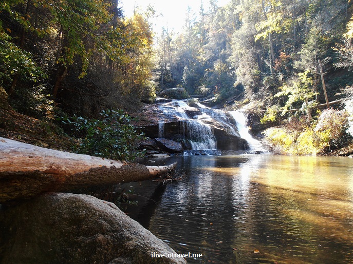
Panther Creek: A Challenging and Rewarding Hike in North Georgia

I was looking for a hike that I could do within 4 hours that was not right on the outskirts of Atlanta.  A friend and I were looking for a more challenging hike than the usual so after selecting a few finalists, we settled on Panther Creek, about an hour and a half north of Atlanta.  We decided to hike 3.5 hrs in to the larger waterfalls and then back.  The entrance to the trail on Panther Creek is on Old Historic 441 in north Georgia, northwest of the town of Ellijay.

Soon after entering the trail, you go under the new 441. After that, you leave hearing highway noise and slowly, but surely, start hearing water running sounds…  The trail is more natural (read, not groomed) and that makes it quite a neat trail to hike.

Panther Creek, trail, hiking, Georgia, cascade, waterfall, nature, outdoors, photo, Olympus

Towards the start of the Panther Creek trail – love the woods

Panther Creek, trail, hiking, Georgia, cascade, waterfall, nature, outdoors, photo, Samsung Galaxy

Lots of rock outcrops where one can imagine people ages ago taking shelter under them

You go down a narrow path and slowly go downhill. Eventually you are closer to creek level and closer to the creek itself.

Panther Creek, trail, hiking, Georgia, cascade, waterfall, nature, outdoors, photo, Olympus

Beautiful colors at the time of the year I visited

Panther Creek, trail, hiking, Georgia, cascade, waterfall, nature, outdoors, photo, Samsung Galaxy

Panther Creek, trail, hiking, Georgia, cascade, waterfall, nature, outdoors, photo, Olympus

More beauty

Panther Creek, trail, hiking, Georgia, cascade, waterfall, nature, outdoors, photo, Olympus

Still waters

There are several low wooden bridges to cross and then one arrives to a first set of cascades with a space that is perfect for camping overnight.

Panther Creek, trail, hiking, Georgia, cascade, waterfall, nature, outdoors, photo, Samsung Galaxy

One of the bridges crossing the creek

Panther Creek, trail, hiking, Georgia, cascade, waterfall, nature, outdoors, photo, Samsung Galaxy

Love these cascades

A couple of times the markers for the path were not visible and we proceeded trusting that the wild we saw in front of us was just an overgrown trail (and, mercifully, we were right!).

Continuing on from that spot, another 30-45 minutes or so depending on pace, one arrives at the upper waterfalls with a sort-of sandy beach to camp overnight or just recover from the hike in. Right before arriving at this waterfall, the terrain becomes a little more challenging and fun. One has to hug the big rocks holding on to the steel-cable handrails. These handrails are anchored on posts, some of which are sturdy and some of which have come loose and are floating, being kept alive by the two neighboring posts! One does need to proceed with care as falling from this rock outcrop would not be fun.

Panther Creek, trail, hiking, Georgia, cascade, waterfall, nature, outdoors, photo, Samsung Galaxy

The steel cable handrail itself is precarious!

Panther Creek was both rewarding and challenging. The raw feel of the trails was a welcome change from some of the other trails I hike in north Atlanta (which are quite nice but well groomed). I highly recommend doing this trail – I sure hope to do it again!

Panther Creek, trail, hiking, Georgia, cascade, waterfall, nature, outdoors, photo, Samsung Galaxy

A nice break after 3.5 miles!

—————————————————————————————————————

Read about these other great hikes in Georgia:

Sope Creek

Sweetwater Creek

Island Ford

Tallulah Gorge

… and more to come!

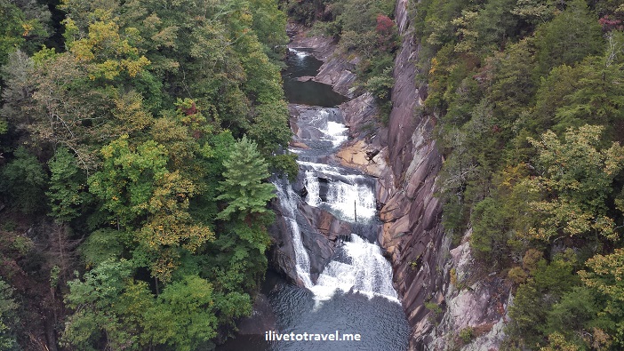
A Hike in Tallulah Gorge State Park

Tallulah Gorge State Park is located pretty much in the northeast corner of the state of Georgia.  The park centers around the Tallulah Gorge around the – guess what- Tallulah River.  The river starts in North Carolina and eventually makes its way to the Savannah River and the Atlantic Ocean.  It has a series of waterfalls which are collectively called -wait for it- Tallulah Falls!  It is supposed to be the most scenic canyon on the eastern seaboard of the U.S. with a depth of about 1,000 ft.  A hike in Tallulah Gorge is a must while in the area!Tallulah Falls, Tallulah Gorge, Georgia, canyon, hiking, north rim, south rim, photo, outdoors, nature, Samsung Galaxy 4

I visited the canyon around mid-October.  It was an unusually warm October so the leaves had not begun to change yet for real.  Driving to the park from Atlanta takes about 1.5 hrs, slightly less if you live or are staying at in the northern suburbs of the metro Atlanta.

The park has an Interpretive Center with information and exhibits for the young and the not-so-young.  These cover the history of the former resort town, local wildlife, and other topics.  The staff at the center is quite helpful and knowledgeable about the park and its vicinity.

Going for an easy hike in Tallulah Gorge

For the non-hiker or those who are interested in seeing some of the waterfalls but not climb steep staircases, the park has natural paths along the north and south rims of the gorge that are pretty easy to walk through.  These paths offer various vantage points, or overlooks, from which to soak in the view.  Walking along the north rim you can see the tower that held the tightrope Karl Wallenda used when he crossed the gorge in 1970!

Tallulah Falls, Tallulah Gorge, Georgia, canyon, hiking, north rim, south rim, photo, outdoors, nature, Samsung Galaxy 4

The view from the north rim near the Interpretive Center

Tallulah Falls, Tallulah Gorge, Georgia, canyon, hiking, north rim, south rim, photo, outdoors, nature, Samsung Galaxy 4

Checking out the gorge from one of the overlooks on the north rim

The north/south rim hike is about 3 miles long round-trip.  Depending on the pace, the hike along the Tallulah Gorge should be doable in a couple of hours.  From the first overlook, closest to the start of the trail at the Interpretive Center, there is a great view of the L’Eau d’Or (Ladore) waterfalls where yours truly had his pic taken!

Tallulah Falls, Tallulah Gorge, Georgia, canyon, hiking, north rim, south rim, photo, outdoors, nature, Samsung Galaxy 4

Looking down at L’Eau d’Or waterfalls from the overlook

Going for a deeper hike down the gorge

For those wanting to get closer to the waterfalls, the river and the bottom of the gorge… there are stairs!!  Over 1,000 steps!

Tallulah Falls, Tallulah Gorge, Georgia, canyon, hiking, north rim, south rim, photo, outdoors, nature, Samsung Galaxy 4, stairs

Let the stairs begin!

From the first overlook where my picture was taken, you can proceed to the Devil’s Pulpit where you get a great face on view of L’Eau d’Or.

L'Eau d'Or, Tallulah Falls, Tallulah Gorge, Georgia, canyon, hiking, north rim, south rim, photo, outdoors, nature, Samsung Galaxy 4

L’Eau d’Or

From this point the large staircase takes the hiker to the suspension bridge that connects the south and north rims of the gorge.

bridge, Tallulah Falls, Tallulah Gorge, Georgia, canyon, hiking, north rim, south rim, photo, outdoors, nature, Samsung Galaxy 4

Crossing the bridge

Once on the south rim, one can access the bottom of the gorge.  On some days, it is possible to go further at the bottom of the gorge but only the first 100 people get the needed pass.  However, because of the water release schedule for the upriver dam, the bottom of the gorge is not always open.  It was not when I went.  That was unfortunate because I would have loved to jump into the pool!!

pool, bottom of the gorge, Tallulah Falls, Tallulah Gorge, Georgia, canyon, hiking, north rim, south rim, photo, outdoors, nature, Samsung Galaxy 4

Pool at the bottom of the gorge

Once you reach the bottom, you can take a look at Hurricane Falls and dream of sliding down those rocks!

Hurricane Falls, Tallulah Falls, Tallulah Gorge, Georgia, canyon, hiking, north rim, south rim, photo, outdoors, nature, Samsung Galaxy 4

Hurricane Falls from the bottom of the Gorge

Tallulah Gorge, waterfalls, falls, Georgia, nature, outdoor

Signs a-plenty – “rattlesnake” weed doesn’t sound good, does it??

hikers, Tallulah Falls, Tallulah Gorge, Georgia, canyon, hiking, north rim, south rim, photo, outdoors, nature, Samsung Galaxy 4

The view you are rewarded with from the rim!

A hike in Tallulah Gorge is very enjoyable and quite doable as day trip from Atlanta or from places in Tennesse and North Carolina.  Do not miss this chance to see an amazing setting, whether for an arduous hike or a stroll!

Read about these other great hikes in Georgia:

Sope Creek

Sweetwater Creek

Island Ford

… and more to come!

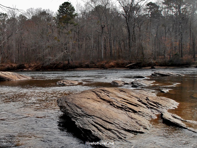
Sope Creek: A Hike, a Creek, and an Old Mill

I was looking for another spot in Atlanta to hike while also hitting some waterway AND hitting history after having enjoyed going to Sweetwater Creek and to Island Ford (on the Chattahoochee River).  Tall order, huh?  NOT in Atlanta!  Plenty of spots along creeks and rivers to find great hiking and reminders of the life in the South back when mills ruled the day.  Enter, stage left, Sope Creek.

I am training for hiking the Camino de Santiago in Spain with Trekking for Kids, an organization that took me to Transylvania’s “Alps” in Romania and to the top of Mt. Kilimanjaro.   As part of my training, I want to do more than Kennessaw Mountain or Stone Mountain.  So after some research and talking to friends, I discovered the many trails that are right within 15 miles of the city, like Island Ford, for example.

But on another weekend, I wanted to try something new.  I was taking friends’ kids out on this hike so it also had to be friendly enough for me and three other kids 🙂  That’s when a co-worker recommended Sope Creek, a creek where a Civil War era mill use to operate and whose ruins you can not only see but also get up close and personal with!

Sope Creek, Atlanta, hiking, tadpoles, nature, outdoors, Georgia, old mill, Civil War, Paper Mill Road, rapids

The old mill ruins

The kids, aged 14, 10, and 8, were excited to come for the hike.  I decided to take the longer way to the creek so that the “hard work” took place before we saw the creek and the mill which I figured would be the highlight of the hike.

Sope Creek, Paper Mill, Atlanta, Georgia, hiking, kids, lake, colorful, photo, travel

Early on the hike, we ran into a small lake.

The park has both hiking-only trails and hiking/biking trails so we did have to keep our eyes and ears open to approaching bikes but the mountain bikers were pretty much nice and careful which we appreciated.  The trails are well-signed and the younger kids enjoyed trying to figure out which way to with the map and the signage while the older kid and I allowed ourselves to be guided.

Sope Creek, Atlanta, hiking, tadpoles, nature, outdoors, Georgia, old mill, Civil War

Tadpoles in our midst!

The trail approached the creek by going almost parallel to it but up high.  It was a nice view and trail which then went away from the creek for a little bit.  We ended up crossing a trickle of a creek right after spotting three deer.

Eventually, we made it to the old mill and the creek.

Sope Creek, Atlanta, hiking, tadpoles, nature, outdoors, Georgia, old mill, Civil War

Looking south

The kids explore the ruins of the mill and then proceeded to walk towards the large rocks at the edge of the creek.

Sope Creek, Atlanta, hiking, tadpoles, nature, outdoors, Georgia, old mill, Civil War, Paper Mill Road, rapids

Kids climbing around the old mill ruins

It was fun climbing and walking on the rocks.

Sope Creek, Atlanta, hiking, tadpoles, nature, outdoors, Georgia, old mill, Civil War, Paper Mill Road, rapids

Two of the three climbing around the rocks

We hung there for a little bit enjoying the scenery and the climbing.  It was also a great spot for pictures and for a snack.

Sope Creek, Atlanta, hiking, tadpoles, nature, outdoors, Georgia, old mill, Civil War, Paper Mill Road, rapids

I love this shot: She looks Photoshopped in!

All that done, we proceeded to exit the park by following the trail that is parallel to the road.  It deviated from the road a little bit because the trail was under repair but it was easy to make it back to the parking lot.

After the hike, we were hungry and the kids had asked for Cracker Barrel (they love it because I keep calling it Crate & Barrel, accidentally!).  It was the perfect ending for a great hike!  The kiddos are definitely hikers and explorers!

Sope Creek, Atlanta, hiking, tadpoles, nature, outdoors, Georgia, old mill, Civil War, Paper Mill Road, rapids

Yours truly

——————————————————————————————————-

Read about these other great hikes in Georgia:

Panther Creek

Sweetwater Creek

Island Ford

Tallulah Gorge

… and more to come!

Chattahoochee River Hikes: Island Ford

Atlanta is well known for traffic, a massive airport, CNN, Coca-Cola, conventions, and Gone with the Wind.  It seems almost cliche-ish when defined in these terms and I can certainly understand that these form or inform people’s image of the South’s “Gate City,” as it was known in the mid 19th century.  What local residents and frequent visitors know, though, is that the city is a vibrant and diverse collection of areas.  The international farmer’s market by I-285 is a great example of this diversity that visitors don’t often get to see.

Another fact that may be surprising is how this city, so built up and loaded with cars, is actually in the midst of the great outdoors.  I shared already about how close Sweetwater Creek State Park is to the city (only 15 miles).  Here I want to shared another great nature spot, right within and right outside the city’s ring road (I-285):  the Chattahoochee River National Recreation Area, part of the U.S. National Park Service.Chattahoochee River, National Recreation Area, National Park Service, hiking, Atlanta, Georgia, photo

The lay of the Chattahoochee River

The Chattahoochee River, or the “Hootch“, starts up in the North Georgia mountains where the Buford Dam was established to control its flow and accumulate water to provide for the city.  It then makes its way to the Gulf of Mexico via western Atlanta then Alabama, then Florida.  The river does not cross the modern city center as rivers tend to do in other cities.  The city’s location was driven by railroad lines connecting the Gulf, the Atlantic ports and the Midwest back in the first half of the 19th century.  So, we did not end up with a river going through the city center (a shame!).

However, it does go through urban areas right outside the city of Atlanta proper and we were lucky that it became a protected area in the 1970s so we could enjoy this bit of nature.  All along the river, as it courses through metro Atlanta, there are parks and trails, offering great walking, running, mountain biking, hiking, picnicking, etc.  Here I want to share with you about one of them and hope to continue sharing other spots in the future.

Island Ford, Chattahoochee river, hiking, outdoors, nature, photo, Olympus, woods, National Park Service

Island Ford, Chattahoochee river, hiking, outdoors, nature, photo, Olympus, woods, National Park Service

I bet it looks very different in the middle of summer!

Island Ford

A few miles outside of I-285, as you head up on GA-400, you reach the headquarters of the Chattahoochee River National Recreation Area’s headquarters.  As with many parks, friendly staff and rangers are a phenomenal source of information and advice, both of which we enjoyed getting.

Island Ford, Chattahoochee river, hiking, outdoors, nature, photo, Olympus, woods, National Park Service

Park rangers are a great source of information to those visiting the park

Again, as with other parks like scene, they park service charges a nominal fee for use of the park in the form of a parking permit that costs only $3.  Bring singles as you make payment by putting the three dollars in an envelope and drop it in a box!

Island Ford, Chattahoochee river, hiking, outdoors, nature, photo, Olympus, woods, National Park Service

Incredible stones everywhere in the area, including in the river!

The trails around Island Ford provide both flat areas as well as steep hills to challenge hikers.  The circuit of trails here could take around 1.5-2.5 hours (depending on how many of the trails you hit and your speed!) and they are suitable for beginners.  Apparently, it is also a good spot for trout fishing – who knew!

trout, fishing, Chattahoochee River, Island Ford, Atlanta, Olympus, photo, hiking

Trout fishing fun

The trails ford a couple of creeks that feed the river and offer great views of the river but also of rock formations that natives are said to have used for shelter as far back as 1,000 years ago!Chattahoochee River, rock shelters, hiking, National Park Service, Olympus, photo, nature, outdoors Chattahoochee River, rock shelters, hiking, National Park Service, Olympus, photo, nature, outdoors

Island Ford, Chattahoochee river, hiking, outdoors, nature, photo, Olympus, woods, National Park Service

The star of the show working his way over a log

The Chattahoochee Parks Conservancy supports parks along the river in many ways to ensure our enjoyment of these natural areas.  Visit their site and become a member or supporter!   


Read about these other great hikes in Georgia:

Sope Creek

Panther Creek

Sweetwater Creek

Tallulah Gorge

… and more to come!

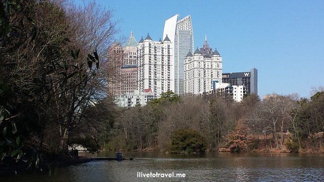
Piedmont Park: An Oasis in the Middle of Atlanta

Atlanta is a city of greenery and a lot of that comes from its many parks.  Many neighborhoods have a park and some, like mine, more than one.  The parks are mostly local to each area though open to anyone as they tend to be city property.  They range from just a wild natural area, to green open spaces, to those with playground sets for the kids.  What is good about Atlanta is that the local neighborhoods step in to help keep these parks clean and alive.

Piedmont Park, Atlanta, Midtown, outdoors, oasis, photo

Piedmont Park forms the eastern boundary of the Midtown skyline

However, Atlanta’s centerpiece in the park category is Piedmont Park, located in the middle of Midtown, easily accessible from every cardinal point.  The park’s history is longer than Atlanta’s own. A land lottery in 1821 distributed the land just ceded by the native Creek Nation of Indians.  Early pioneers acquired a forest that would later become Piedmont Park to build their farm (the Walker family) before Atlanta itself was established!  It is interesting to note that the original cabin was built on what is now called “Active Oval” where an oval track’s center fields host any number of sports activities.  Another cabin was built a couple of decades after the first one in the area where the Driving Club sits now.

The Active Oval today looking south towards downtown

The Active Oval today looking south towards downtown

The area became the location of many expos in the late 1800s and that’s how the park as we know it began to take shape.  The Piedmont Exposition of 1887 and the Cotton States and International Exposition of 1895 are the most important ones, with the latter being a World Expo to promote the southern states internationally and it ran for about 100 days and attracted 800,000 visitors, way before highways and planes facilitated bringing visitors to Atlanta.  Pretty impressive.

Statue, Gate City, Atlanta, Piedmont Park, southern history, travel, photo

One of the many historical “markers”, this one to the Gate City (as Atlanta was referred to in those days) Guard

The park was finally bought by the City of Atlanta in 1904 after hesitating many times because it was “so far” from the city (at that time, of course, Atlanta was just what we know as downtown).  A lake, steps, tennis courts, and other landscape changes (including carving out what is now the Active Oval to give it its current topography) were implemented in those years.  The Atlanta Botanical Gardens were established along the northwestern edge of the park (worth a visit any time of the year but especially for the winter night lights!).

Piedmont Park, Atlanta, Midtown, photo, lake

Man-made lake installed decades ago

But this park never ceases to be improved.  In the last decade, the park underwent major “renovations” with paths being installed and a dog park being established.  Sadly, the old railroad line that used to run along its eastern edge has disappeared (at least part of it) — Atlanta may be one of very few places were destroying history is celebrated as “progress” (to be in the company of Beijing in this category is not a compliment, folks…).  I enjoyed climbing an old train there once in the younger days.  But all in the name of progress and of creating a better park space in the midst of the hustle-and-bustle that we call Atlanta.

Piedmont Park, train, railroad line, garden, Atlanta, Midtown, photo

Where the train use to run, at least the land has been put to good use (a garden)

The park sometimes hosts events like festivals, and is a great place for a walk, a run, a swim, or a picnic.  Back in my college days, a hot balloon race used to take off from the southeastern fields and it was quite the sight.  The movie in the green event allowed folks to come and watch a movie on a summer evening while bringing food and beverages to enjoy.

Piedmont Park, Atlanta, Midtown, photo, walking, jogging

Great place to walk, run and be with friends

The park has evolved over the decades and is under good stewardship of the city and a conservancy group which will help ensure the park continues to be an oasis in Atlanta for current and future generations to enjoy.Atlanta, spring, flowers, Piedmont Park, photo

What parks exist in your town that serve as great outdoor gathering places?

%d bloggers like this: