Hiking in Nepal: On the Way to Namche Bazaar! (Day 2)
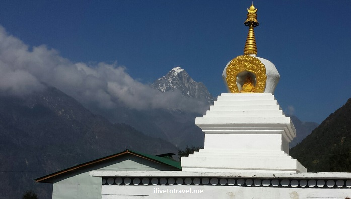
On Day 2, we left our teahouse in the tiny spot of Tok Tok (9,000  ft / 2,800 m) at around 8:45AM to head, following the route to Everest Base Camp, to Namche Bazaar, a rather bigger town than most in the area (actually, THE biggest).  This would have us climb over 2,000 ft in the last 2.5 hours of the hike that day, a rather ambitious and challenging effort (except for the super fit and those used to the altitude, perhaps – I fell under neither success category…).

Leaving our spot in Tok Tok, we stood for a group photo as one of the trekkers was not continuing beyond Tok Tok.

Tok Tok, trekkers, Everest Base Camp, Nepal, Himalayas, trekking

Group photo!

Nepal, Himalayas, trekking, hiking, Tok Tok, bridge, river, Everest Base Camp

Our first bridge of the day was right outside the teahouse – watch out for the pack animals!

On the trail to Everest Base Camp…

Soon thereafter, off we went walking on terrain that was becoming familiar to us:  rocks, dirt, steps, pack animals, farms, debris from the earthquake, reconstruction, and the river.  It is a rugged but peaceful terrain; except when the pack animals come – at that point you make a quick move towards the inside of the trail, not the side facing the steep dropoff!  On this day, we would cross the river four times if memory serves me right.

Everest Base Camp, trail,trek, trekking, terrain, hiking, Nepal, Himalayas, outdoors, adventure, Olympus

Steep climbs every day!

Everest Base Camp, trek, trekking, terrain, hiking, Nepal, Himalayas, outdoors, adventure, Olympus

Pack animals: these were carrying a very light load

Everest Base Camp, trail,trek, trekking, terrain, hiking, Nepal, Himalayas, outdoors, adventure, Olympus

Typical stop for trekkers

Entering the Sagarmatha National Park

Later that morning, we officially entered the Sagarmatha National Park (which is the park where Mt. Everest sits) via the Jorsalle gate (which is right outside of Monju on the way to Jorsalle).  There was signage offering good advice for trekkers in dealing with acute mountain sickness (there are always those who are unprepared…).  More importantly we passed a traditional kani gate which incorporates prayer wheels and colorful paintings on the walls and ceilings.  This gate marks our entrance in the sacred valley of the Sherpa (a term that refers to an ethnic group, not a job, as we learned…):  the Khumbu.  I loved the rules suggested to those who enter the valley (see photo).

kani gate, Jorsalle gate, Sagarmatha, National Park, Nepal, Everest Base Camp, tradition, Buddhist, sacred valley, Khumbu

The kani gate marking the entrance to the sacred valley

Sagarmatha, Kani gate, Jorsalle, Nepal, Himalayas, Buddhist painting, art, color, photo, travel, Olympus

Ceiling painting

Sagarmatha, Kani gate, Jorsalle, Nepal, Himalayas, Buddhist painting, art, color, photo, travel, Olympus

Wall painting and the ever-present prayer wheels at the kani gate

Acute mountain sickness, Nepal, Sagarmatha, warning sign

Warnings about acute mountain sickness

Sagarmatha, National Park, Nepal, kani gate, Jorsalle, park rules, travel

Follow these rules!

Breaks from the trail:  tea and food

While the actual walk is rewarding despite the challenging parts, one of my favorite moments is when we stop 🙂  Yes, it is about getting a break from the effort.  But it is also about the camaraderie over that cup of tea, lemon or mint with the latter being my favorite.  As we all have different paces, non-walking time is when we get to share with those we don’t keep up pace with (or those who can’t slow down easily!).  After tackling the first mile (which was not a walk in the park), we made a restroom stop at Benkar but did not even sit-  this was not our morning break for tea.

Everest Base Camp, trail,trek, trekking, terrain, hiking, Nepal, Himalayas, outdoors, adventure, Olympus

Brief stop to use the ‘facilities’ and take a snack out

Everest Base Camp, trail,trek, trekking, terrain, hiking, Nepal, Himalayas, outdoors, adventure, Olympus

Resuming our hike with a nice downhill

So we trudged along and, after we entered the Sagarmatha NP, we later hit our morning break at Monju (or Monzo) at a place that I would stop at on the way back to Lukla.  The outdoor terrace was very spacious and comfortable (perhaps because we were the only ‘crowd’ there) and the temperature was great so we enjoyed sitting in the terrace sipping our tea!

Everest Base Camp, trail, route, Monju, Monzo, Nepal, Himalayas, Trekking for Kids, travel, outdoors, adventure, Olympus

Tea time in Monju!

And then we proceeded to Jorsalle where, not 30 minutes later, we would have lunch outdoors by the river at a teahouse there.  It was a great stopping point right by the trail (as most are).  It was a good break before the final push, and I mean PUSH, to Namche Bazaar – we would be starting a serious vertical climb over a rather short horizontal distance.  Heaven help me!  We left our lunch ‘resting place’ at around 1 PM.

Jorsalle, Khumbu, Nepal, Himalayas, Everest Base Camp, trekking, trail, Dudh Koshi, river

Approaching Jorsalle, our lunch ‘town’

Jorsalle, Khumbu, Nepal, Himalayas, Everest Base Camp, trekking, trail, Dudh Koshi, river

Lunch time in the sun!

Bridges crossing the Dudh Kosi River

Before I get to the monster climb…  This day was made fun by the many bridges low and high, short and long we would cross.  If you are not a fan of suspension bridges, this may not be your favorite day but the most important thing to mind are the pack animals, not the height of the bridges!  Here are some images from the “day in bridges.”

bridge, Nepal, Dudh Koshi, river, Everest Base Camp, route, Olympus, travel, outdoors, trekking, hiking, Khumbu, Sagarmatha

Pack animals have right of way – if you are smart!

bridge, Nepal, Dudh Koshi, river, Everest Base Camp, route, Olympus, travel, outdoors, trekking, hiking, Khumbu, Sagarmatha

Lovely scenery from the bridge’s vantage point

bridge, Nepal, Dudh Koshi, river, Everest Base Camp, route, Olympus, travel, outdoors, trekking, hiking, Khumbu, Sagarmatha

One of the smaller bridges we dealt with

bridge, Nepal, Dudh Koshi, river, Everest Base Camp, route, Olympus, travel, outdoors, trekking, hiking, Khumbu, Sagarmatha

Beautiful spot (notice the prayer flags)!

bridge, Nepal, Dudh Koshi, river, Everest Base Camp, route, Olympus, travel, outdoors, trekking, hiking, Khumbu, Sagarmatha

Loved walking this close to the Dudh Koshi River

bridge, Nepal, Dudh Koshi, river, Everest Base Camp, route, Olympus, travel, outdoors, trekking, hiking, Khumbu, Sagarmatha

And then we got to this… (the bottom bridge is closed now)

bridge, Nepal, Dudh Koshi, river, Everest Base Camp, route, Olympus, travel, outdoors, trekking, hiking, Khumbu, Sagarmatha

And we are about to walk across the highest one!

bridge, Nepal, Dudh Koshi, river, Everest Base Camp, route, Olympus, travel, outdoors, trekking, hiking, Khumbu, Sagarmatha

View down from the highest suspension bridge

bridge, Nepal, Dudh Koshi, river, Everest Base Camp, route, Olympus, travel, outdoors, trekking, hiking, Khumbu, Sagarmatha

View down from the highest suspension bridge

And our awesome endpoint:  Namche Bazaar

The route to Everest Base Camp is not a steady uphill.  No place ever is (even Mt. Kilimanjaro has its downhills as you climb) but this was as much going down as you have gone up in many stretches.

In fact, this day, on a 5.3-mile (8.5 km) route, our net climb was around 2,300 ft (about 800 m) – we climbed much more (upwards of 4,000 ft) and descended a good bit.  But after lunch what we faced was mostly a severe uphill, especially after the last suspension bridge (the highest one).  And the trail was very rugged to boot.  Hard stuff.  I didn’t know how I could finish it.  And remember, we were climbing to our end point at over 11,300 ft (3,400 m) so the thin air was having an impact (as a reference point, once in Namche Bazaar, we would be at 67% oxygen level vs. sea level!!).  I had to stop every now and then just to catch my breath especially after a stretch where the ‘steps’ (rocks) were higher. Not knowing how much more I really had was both a blessing and a curse.  Certainly I would not want to know how much more most of the way but maybe during the last 30 minutes I would have wanted to know that Namche was THAT close.

With the incredible climb at the end, Namche Bazaar could not have come sooner.   So, it was awesome when we rounded a corner about 2.5 hours after lunch and we saw this town incredibly nested in what looked like mother nature’s own amphitheater:  Namche Bazaar!  It was a photo op moment for sure and we had earned the rest day coming up on Day 3!

Namche Bazaar, Nepal, Everest Base Camp, trail, route, Himalayas, trekking, hiking, outdoors, adventure

I shall name this photo: “The first time I saw sweet Namche”

Namche Bazaar, Nepal, Everest Base Camp, trail, route, Himalayas, trekking, hiking, outdoors, adventure

The moment I stopped when I rounded the corner – best moment ever!

Namche Bazaar, Nepal, Everest Base Camp, trail, route, Himalayas, trekking, hiking, outdoors, adventure

My trek roommate and I celebrating we had survived

——————————————————————————————

Check out other related posts!

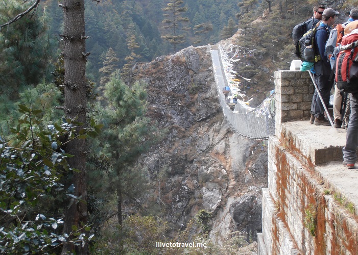
Hiking in Nepal: Lukla to Tok Tok (Day 1)

My trek in the Himalayas followed the route to Everest Base Camp.  I only had two weeks’ vacation so I was short one week to make it all the way to “EBC” since my visit to Nepal included an extra number of days to help in the re-building of a school that was destroyed during the April 2015 earthquake in the village of Kumari.  It was a great trip and I did not want to miss seeing Mount Everest in person.  Making that decision was not the hardest part, figuring out what I need to take was!  (Read here for how I packed for the trek!)

However, I went on this trek with Trekking for Kids because I knew some of the folks going and it was not a bad time to be away from work (is there ever a good time??).  So my trek was going to be from Lukla to Deboche, past the Tengboche monastery.  As it turned out, that ended up being a good choice since my stepfather died back home the day before I left Nepal for home.  But, before that turn of events, I was already glad I had chosen to not go all the way.

Day 1 took us from Lukla (2,860 metres (9,383 ft)) to Tok Tok (2,760 metres (9,o55 ft)). While an overall descent, there were plenty of climbs and descents along the way!

Nepal, Himalaya, route, Tok Tok, Lukla, map, trekking, Everest trek, adventure

Our starting point and ending point for day 1

Starting the trek:  getting to Lukla

Starting the trek in Lukla required first getting to Lukla.  As I shared in an earlier post, either one does a local bus and then a few days’ hike to get to Lukla or one flies into one of the “most dangerous” airports in the world:  Lukla (LUA).  I did the latter for a couple of good reasons:  that was what was pre-planned by Trekking for Kids and I didn’t have enough vacation time anyway!

You can read the details in the earlier post but the short of it is:  I made it to Lukla alive and without too much suffering 🙂

Lukla, Nepal, airport, runway, travel, adventure, Samsung Galaxy

The Lukla airport – a very short and dramatic runway!

Getting the trek going:  leaving Lukla

After we landed in Lukla, getting our bags was a piece of cake (the airport is tiny, after all).  From there to our breakfast stop (at a hotel we would return to at the end of the trek) was a very short walk (Lukla is tiny, after all).  We got there and, as we had left Kathmandu at the literal crack of dawn, we proceeded to have some breakfast before heading out.  Our guides had to sort our things with the porters we were picking up in Lukla so we had ample time.  I can’t really recall what I had but nothing too heavy as we were leaving for a few hours’ hike.Everyone was itching to go and, when we finally did, I think we had a little bit of adrenaline flowing!  Close to leaving Lukla, we came to our first gate and prayer wheels and the backdrop was phenomenal in the deep blue sky ahead.  It was a sign of the great day ahead!

Though we started the hike at over 9,000 ft, we warmed up pretty quickly as the hike progressed.  It felt so good!  Hamlets in this part of Nepal are charming probably because of the color applied to the window and door frames and we started noticing this early on.

Nepal, Himalayas, house, hamlet, blue, travel, Olympus, trekkers

Approaching a hamlet

Nepal, Himalayas, house, hamlet, blue, travel, Olympus

House along the trek route

We crossed our first hanging bridge on this day (one of two hanging bridges that day).  It was not too high (I am not afraid of heights, thankfully) and it was certainly long.  We would follow this river all the way to near Namche Bazaar.  We also crossed another bridge, a truss one, that day.  I noticed that some parts of the route, as it passed through small “hamlets,” were paved with stones while others were dirt paths.  It was nice to have the variation in the route – just like it was nice to have all the uphills and downhills mixed.

Nepal, Everest trek, Dhudh Kosi, river, trekking, Olympus

Approaching the Dhudh Kosi River and the hanging bridge

River, Dudh Kosi, Nepal, glacier water, Everest trek, trekking, nature, outdoors

Beautiful waters, courtesy of glacierland!

Buddhist faith along the route

Along the way we passed different-sized prayer wheels and collections of Tibetan tablets (in sanskrit) that are so iconic and that speak to the concreteness of the faith in that region of Asia.  I tried to not miss spinning prayer wheels and we certainly made sure we passed the “monuments” on their left as tradition/faith requires.

stupa, Buddhism, sanskrit tablet, stupa, Himalayas, Everest trek, Nepal, travel, outdoors, faith, religion, photo, Olympus

Sanskrit tablets and a stupa

prayer wheel, Buddhism, sanskrit tablet, stupa, Himalayas, Everest trek, Nepal, travel, outdoors, faith, religion, photo, Olympus

A prayer wheel asking to be spun

A hiker has to eat!

Along the way we stopped for lunch at a beautiful spot where the route made a 90-degree angle.  The place, the Wind Horse Lodge and Restaurant was a perfect spot, idyllic, for the stop.  We sat outside at tables on the small lawn, graced by marigolds along the edges.  Until clouds rolled over and it started getting cold.  We promptly found tables indoors and the lunch was pretty darn good:  fried noodles and rice along with fried mini empanadas (my Latin roots betray me as that is not what they call them there!).

Nepal, Everest trek, food, fried noodles, travel, trekking, teahouse

Lunch!

Ending our hike in Tok Tok

Bellies full and feet rested, we proceeded on our hike.  I try on these treks to not study the route we are going to take as I don’t want to be “expecting” the next stop or calculating how much longer we have to go – I want to enjoy the moment though, I admit, at times when I am feeling tired, I start trying to figure out how much longer I have to go 🙂

We arrived at our teahouse in Tok Tok (River View Lodge) and, as usual, it is a great feeling to hear the words “We are here” when we arrive at our resting place for the night!  It was a tiny spot nestled between a hill and the river.  I wish it had been a tad warmer to stay outside in the evening.

teahouse, room, Everest trek, lodging, Nepal, Himalayas, travel, trekking, travel, Olympus, photo

My room at the teahouse

teahouse, room, Everest trek, lodging, Nepal, Himalayas, travel, trekking, travel, Olympus, photo

The dining room (aka, hanging out room) at the teahouse

In the end, it was a spectacular first day trekking in the Himalayas and I slept well that night!  I leave you with one of my favorite views from that day!

stupa, Buddhism, stupa, Himalayas, Everest trek, Nepal, travel, outdoors, faith, religion

Just magnificent


Other posts related to this hike:

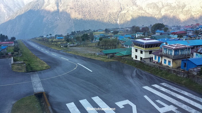
Flying into Dangerous Lukla Airport in Nepal

I recall seeing a few years ago a TV show about the world’s ten most dangerous airports. Tegucigalpa, St. Maarten and a few others made the list.  And so did Lukla, Nepal.  Lukla is the typical starting point for anyone trekking along the route to Everest Base Camp, or to other points in the Himalayas. The alternative to the 35-min flight to Lukla (LUA) from Kathmandu is a long bus ride plus a few days of trekking to reach Lukla. I was not thrilled at the prospect of landing in one of the most dangerous airports but there really was no choice.

Heading to Lukla

The Lukla airport was built by none other than Sir Edmund Hillary himself in 1965 to facilitate developing the trekking business that he felt the local population needed.  The Lukla airport , officially named Tenzing-Hillary Airport after the first two people to have summitted Mt. Everest, was a dirt airstrip until just 1999.  Lukla is a town of a few thousand inhabitants perched high at around 2,840m / 9,300 ft above sea level.  Flights in and out of Lukla mainly fly in the morning when the weather and the visibility are what they need to be for a successful flight (read: does not crash).  Only planes that can handle short takeoffs and landings can operate from Lukla as the runway is only 1,700 ft (500m) long (or so) – that ain’t long at all!  Flights can easily be canceled for the day if the conditions are not right which could be more than one day in a row, leaving hundreds stranded in this small hamlet in the highlands of Nepal…  So beyond the flight involving a “dangerous” airport, one gets to worry about will the flight even go and what happens to the rest of the itinerary if the day is bust…

In any case, there are several airlines that run flights continuously in the morning to and from Lukla.  It is like a bus service of sorts with planes making quick turnarounds at either airport (Lukla/Kathmandu) to take advantage of the right weather.

Lukla, Tara Air, boarding pass, Nepal, flight, airline, travel, Everest

Boarding pass to Lukla

The domestic terminal in Kathmandu is small and easy once you get past the chaos of getting to the airline counter and checking in.  We had no real problems, thanks to our local guides that were going to be traveling with us – they knew their way around!  After being dropped off, we walk along a covered walkway to a building in the back past a new building under construction.  The old building was old indeed but it was functional.  Once the flight is called (other Lukla flights were called too), we stepped out and there were 2-3 buses awaiting to take people to their planes.  It was a bit confusing and finally someone pointed us to our bus based on our boarding pass.

The plane sat maybe 20 people and the flight was not full.  I got a seat on the left so I would be facing north (towards the Himalayas).  Unfortunately, the windows were very dirty which assured that photos would not be National Geographic kind of material (that is my excuse anyway…).  Gosh, if I’d known and they’d let us, I would have gotten off the plane pre-takeoff and cleaned my window!

Himalayas, Nepal, window seat, airplane, flight, Tara Air, Lukla

The taller Himalayas via dirty window

Himalayas, Nepal, window seat, airplane, flight, Tara Air, Lukla

At times, the ground was not far below us…

Himalayas, Nepal, window seat, airplane, flight, Tara Air, Lukla

Small village – one can see the local stupa left of center

Before taking off, the flight attendant (yes, there is one) checked that our seat belts were fastened and handed out hard candy (to choke on when the plane jumped?? no, thanks) and cotton balls for our ears – yes, I guess it was to be a noisy flight!  Those tasks and getting us in and out of the plane was all she had time to really do on such a short flight.  But I still appreciated her for taking care of us!

Dangerous Airport?

The danger reputation stems from the fact that the runway starts at the edge of the mountain and runs uphill (a 12% grade) until either the plane has stopped and turned or, it has met the wall.

Lukla, airport, Nepal, dangerous, Himalayas, travel, flight, airplane, landing, takeoff, runway

The full runway (control tower on the right)

I have read, and was also told by a pilot, that part of the issue with landing is the uphill nature of the runway with the far end being higher than the end nearer to the pilot – this situation can trick the eye, giving the pilot a false sense of the aircraft’s vertical position before landing, potentially leading to accidents.

Lukla, airport, accident, danger, Nepal, runway, flight

A plane meets the wall

On the reverse (the takeoff out of Lukla), either the plane catches air at the end of the runway where the runway meets the cliff’s edge, or it drops when the runway runs out until the plane catches lift (which I would hope it does…).

Lukla, airport, flights, Nepal, runway

See what I mean about “up or drop” (Source: www.theaustralian.com)

Truthfully, and maybe naively, neither landing nor takeoff worried me much. What worried me the most was the turbulence that can be encountered on the way to and from Lukla.  Not helping things was the name of our Nepalese airline:  Tara Air.  I was happy until someone pronounced it, making it sound like “terror air” (pronounced with a thick Boston accent) which sent images flying (pardon the pun) all across my brain of a small plane jumping around due to high winds – a terror inducing ride ahead?  Hopefully not!!!Tara Air, Lukla, Kathmandu, Nepal, flight, airline, airport, Himalayas, trekking

Upon boarding, I looked into the seat pocket in front of me and found the air sickness bag which left no doubt as to what its purpose was…  I should have taken it with me but at least I took a picture of it.Tara Air, Lukla, Nepal, air sickness bag, vomit bag

The flight into Lukla had gone very smoothly – no turbulence at all!  And then we started circling.  I was thinking to myself:  “so close and now we start circling” – was it weather-related, I wondered?  The delay turned out to not be about fog or weather issues and we experienced no turbulence.  The issue was that, since the Lukla airport only has four parking spots for planes and they were “taken,” we had to wait for a plane to take off before we were allowed to land.  That was a new one to me!  The flight back from Lukla was also completely smooth giving me a 2-for-2 no-turbulence flights so I may consider never going back since I had such good luck on my first visit to Lukla!

Back to landing in Lukla:  it was pretty darn cool as the small plane’s cockpit was open for us to see what was ahead – including seeing the runway ahead as we landed – or the mountains we were flying into before that.

Lukla, airport, flight, Nepal, cockpit, cockpit view, Himalayas, airplane

The view out of the cockpit – how cool is that!

Leaving Lukla, the plane actually took off the ground before the runway ended so no drop was experienced, maybe to the chagrin of those in the plane who love roller-coasters – but not me!  Here is a video of my own takeoff – notice when we leave the runway, right before it ends (it is a noisy video so make sure you are not at max volume!).

In the end, as you may surmise, this was a far better choice than the bus and the walk 🙂  And now I can say I “survived” one of the world’s most dangerous airports!

ilivetotravel, Raul Pino, flying, window seat, travel, Lukla, Nepal, Tara Air

Happy flyer – and dapper too!


Pin this crazy airport to your travel board!

most dangerous airport, scary flight, flying into Lukla, Nepal, airport, Everest

%d bloggers like this: