Great Drive Series – St. Ignatius to St. Regis, Montana

While exploring northwest Montana with a friend this past September, we tried to chart different routes as we covered a loop over a 4-day visit to the area.  We started in and finished in Spokane but wanted to minimize taking the same route twice.  We succeeded in that effort save for the stretch on the interstate between Coeur d’Alene, Idaho and Spokane, Washington.  After leaving Bigfork by Flathead Lake, we drove south via Polson to the town of St. Ignatius on Route 93.  We had some options to get back towards Coeur d’Alene and we choose a back route to minimize time on I-90.  This route would take us from St. Ignatius to St. Regis first on Route 200 and then on Route 135.  It was a great choice!

St Ignatius, Montana, Catholic mission, mountains, water tower

The approach to the town of St. Ignatius was impressive!

St. Ignatius, Montana

St. Ignatius was a mission initially established around the mid-19th century in the Flathead Indian Reservation in this part of Montana (the original log cabin still stands).  The current Catholic church dates from the 1890s and is quite impressive in this town of less than a 1,000 residents or so.

St Ignatius, Montana, Catholic mission, mountains, water tower

House in St. Ignatius

The church was undergoing renovations when I went and we got to meet the pastor who was assigned a few years ago to oversee the restoration efforts.  He greeted visitors on the day I went and explained the efforts right up until a family arrived for a baptism when he put on the right gear and proceeded to welcome a little one into the faith.St Ignatius, Montana, Catholic mission, mountains, water tower, Catholic ChurchSt Ignatius, Montana, Catholic mission, mountains, water tower, Catholic ChurchSt Ignatius, Montana, Catholic mission, mountains, water tower, Catholic Church St Ignatius, Montana, Catholic mission, mountains, water tower, Catholic Church, art restoration St Ignatius, Montana, Catholic mission, mountains, water tower, Catholic Church

The Road to St. Regis

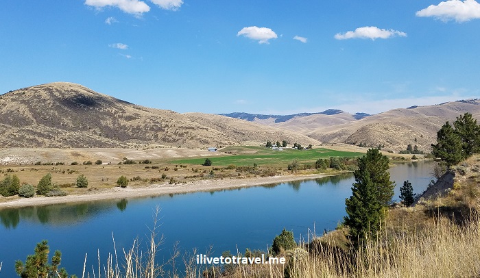
After leaving St. Ignatius with its beautiful reminder of times past, of faith, and of those who served selflessly the latter in the former, we got on the road to St. Regis.  It was a beautiful road with many amazing landscapes and photo opportunities that I share here so you can have a glimpse of the beauty of this not-often-visited part of our country.  I leave you with those images and wish to return!

Montana. driving across Montana, road trips in the U.S., Flathead River

Along the Flathead River

Montana. driving across Montana, road trips in the U.S., Flathead RiverMontana. driving across Montana, road trips in the U.S., Flathead RiverMontana. driving across Montana, road trips in the U.S.Montana. driving across Montana, road trips in the U.S.Montana. driving across Montana, road trips in the U.S.Montana. driving across Montana, road trips in the U.S.

Montana. driving across Montana, road trips in the U.S.

Along the Clark Fork River

Montana. driving across Montana, road trips in the U.S.


Scenic drive in Montana from St. Ignatius to St. Regis

3 Places to See in the Remote Corners of Idaho and Montana

Up in the panhandle of Idaho and the northwest corner of Montana, there is some spectacular, largely unspoiled scenery.  I imagine not many get to see these lands as people focus on Coeur d’AleneBig Sky or Glacier Mountain National Park.  Well, it may make sense that they focus on those places but, if you have the chance, venture off-the-beaten-path.  I did just that simply on intuition, assuming/hoping that the remote corners of Idaho and Montana would deliver.  I was not disappointed.  Lake Pend Oreille, Ross Creek Cedar Trail and Kootenai Falls delivered!

#1 Before Montana: Idaho and Lake Pend Oreille

On my way to NW Montana, we drove north from Coeur d’Alene on route 95 through the town of Sandpoint to take Route 200 around Lake Pend Oreille.  Originally we had planned to go north past Sandpoint to Bonners Ferry and then take U.S. Highway 2.  However, the visitor center in Sandpoint recommended not continuing north on Route 95 but taking Route 200 instead to enjoy the scenic drive along the lake’s shore.   The exact quote was “I don’t why young punks insist of going north to Bonners Ferry”; I was flattered by the “young”…

In any event…  Lake Pend Oreille is the 5th deepest lake in the U.S. and the 38th/39th largest lake in the country.  Interestingly, it became the second largest naval training ground in the world during World War II after the attack on Pearl Harbor – who knew!

Lake Pend Oreille, Idaho's panhandle, map, great drive

Lake Pend Oreille looks like an ear – or a shrimp

The name of the lake means ear pendant in French which makes sense as it looks like an ear on the map.  However, it was named back when the shape was not as evident.  But, a likely explanation I read was that the Kalispeli residents of the area, whom the Canadian traders ran into, did wear ear pendants.

I don’t know what our original planned route would have been like but Route 200 around the lake was right on point. Lake Pend Oreille’s coastline is nice and curvy and there are plenty of pull-offs to stop and soak it all in.Lake Pend Oreille, Idaho, nature, great lakes, driving in the pacific northwestLake Pend Oreille, Idaho, nature, great lakes, driving in the pacific northwestLake Pend Oreille, Idaho, nature, great lakes, driving in the pacific northwest

We were also advised to try The Pantry bakery in Clark Fork where locals make delicious and fresh pastries (and one could pick up something for lunch too).  We did stop and enjoyed apple and cherry pies and bought this phenomenal chocolate pound cake that I enjoyed the rest of the trip!Clark Fork, Idaho, Pend Oreille, great drive in the pacific northwest

#2 Ross Creek Cedar Trail in Route 56

Once we left Clark Fork, the visitor center advisor had also suggested we take Route 56 on our way to get to U.S. Highway 2 as the Ross Creek Cedar Trail park was worth a stop and Route 56 was quite scenic.  Our plan all along had been to get to Hwy 2 (but by Bonners Ferry, if you recall…) to enter Montana so the recommendation would still allow us to do that, so we took it.  Some time after crossing into Montana from Idaho on Route 200, we found Route 56.Ross Creek Cedar Trail, hiking in Montana, exploring western Montana, massive cedar tree

Ross Creek Cedar Trail was a short (1 mile or so) walk through a grove of cedar trees.  The tree trunks were massively wide at their bases.  Some of the trees are 1,000 years old (I found it mindboggling but the forest service website says so!).  It was a nice way to stretch the legs on an easy trail and breathe clean, fresh air!  (Well, as long as you are not close to the vault toilets… what a situation!)Ross Creek Cedar Trail, hiking in Montana, exploring western Montana, massive cedar treeRoss Creek Cedar Trail, hiking in Montana, exploring western Montana, massive cedar tree Ross Creek Cedar Trail, hiking in Montana, exploring western Montana, massive cedar treeRoss Creek Cedar Trail, hiking in Montana, exploring western Montana, massive cedar tree

The drive out of the park along route 56 going north towards Troy was fun as it was not highly trafficked and the scenery quite enjoyable.  Driving north seeing the mountains ahead made for a memorable drive!

Ross Creek Cedar Trail, hiking in Montana, exploring western Montana, massive cedar tree

Heading out of the Ross Creek Cedar Trail park towards route 56

Ross Creek Cedar Trail, hiking in Montana, exploring western Montana, massive cedar tree

Views off route 56

Ross Creek Cedar Trail, hiking in Montana, exploring western Montana, massive cedar tree

Views off route 56

Kootenai River, route 56 in Montana, Kootenai Falls, US Highway 2 in Montana

Entering Kootenai River Country in route 56

#3 Kootenai Falls in Montana

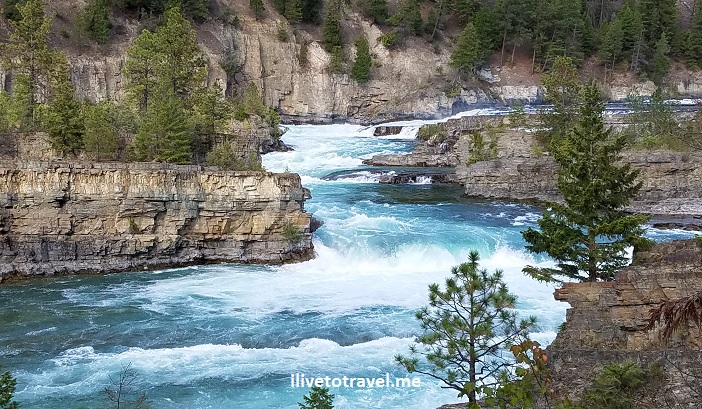
Soon, we reached Hwy 2 and and headed east to get to Kootenai Falls, about 4 miles away or so.  Easy to pull off the road into a parking area next to the trail-head.  It did not take long to see why this spot is so highly recommended as a must-see. The hike itself is not too strenuous but it is not a flat, smooth path.  But before you get there, you will have to go down a few flights of stairs in a large metal staircase that helps cross over the railroad line that goes through the area.

I will let the photos speak for themselves, just know that there are two paths:  one to the main part of the falls and the other to a swinging bridge that serves a a good vantage point to look at the falls.  Do cross the bridge as there is a good vantage point from there too.Kootenai Falls, northwest Montana, Off the beaten path Montana, natureKootenai Falls, northwest Montana, Off the beaten path Montana, natureKootenai Falls, northwest Montana, Off the beaten path Montana, natureKootenai Falls, northwest Montana, Off the beaten path Montana, nature

Kootenai Falls, northwest Montana, Off the beaten path Montana, nature

Some spectacular fishing spot!

Kootenai Falls, northwest Montana, Off the beaten path Montana, natureKootenai Falls, northwest Montana, Off the beaten path Montana, natureKootenai Falls, northwest Montana, Off the beaten path Montana, natureKootenai Falls, northwest Montana, Off the beaten path Montana, natureKootenai Falls, northwest Montana, Off the beaten path Montana, nature

Kootenai Falls, northwest Montana, Off the beaten path Montana, nature

Photo opps galore!

Kootenai Falls, northwest Montana, Off the beaten path Montana, nature

Check out the falls in motion!

Do you have other suggestions for exploring the remote corners of Idaho and Montana ??

%d bloggers like this: