Cross-Country Drive Day 3 – From the Grand Canyon to Amarillo, Texas

A brief summary of day 3 of my cross-country drive: Grand Canyon to Amarillo, Texas, begins with the stats!

Stats of the drive

Third day: Grand Canyon National Park (GCNP) in Arizona to Amarillo, Texas

Routes taken: Route 64 (south) to I-40 east, crossing New Mexico

Departure time: 6:20AM (Pacific time in Arizona)

Arrival time: 7:20PM (Central time in Amarillo)

License plates spotted: 43 (two days in a row! oddly for the proximity, we did not see Arkansas)

A Grand Canyon sunrise with deer

One key benefit of staying right there was the ease of getting to see the Grand Canyon at sunrise. Not that getting up for a 5:15AM daybreak was easy but, certainly, a ton easier than if I had been outside of the GCNP. In fact, I am pretty sure I would NOT have done the sunrise thing if it required an hour drive before 5:15AM!

sunrise, Grand Canyon, rim view, Arizona

Needless to say, I was not the only one out admiring the sun’s rise. A few deer accompanied us right between the lodge and the edge of the path though they seemed more interested in the grass than the colors of the canyon walls!

Thunderbird Lodge, Grand Canyon, rim view, Arizona, deer
A tourist at the Grand Canyon

Driving through New Mexico to get to Amarillo, Texas

Grand Canyon to Amarillo, steakhouse, famous steak, great drives, road trip southwest
Non-descript terrain for a good part
Grand Canyon to Amarillo, steakhouse, famous steak, great drives, road trip southwest, new mexico roadside diner
Diner at Grants, NM, right before the duststorm part of the drive
Grand Canyon to Amarillo, steakhouse, famous steak, great drives, road trip southwest, new mexico
So long New Mexico, I hardly knew ya!
Grand Canyon to Amarillo, steakhouse, famous steak, great drives, road trip southwest, welcome to texas
Grand Canyon to Amarillo, steakhouse, famous steak, great drives, road trip southwest, wind farm, windmill

The windmills above are not properly given justice by this photo. The line of windmills we encountered sometime after crossing into Texas lasted miles and there were multiple rows well beyond the right side of the photo. It was an amazing amount of windmills. As big as everything is in Texas!

Steak night at the Big Texan

And speaking about big in Texas, the Big Texan enters the picture. We stayed next door and ventured to this place famous for its challenge to anyone who dares…

It says ranch but I saw no cows, alive that is!

The challenge is to eat a 72-ounce piece of steak, cooked to order, along with all the sides pictured below in one hour. If you eat it all, besides the stomach ache I imagine ensues, you get the meal for free. Otherwise, you pay $72. We saw two guys get up on the stage to try it but we did not stay to see the drama finish…

Grand Canyon to Amarillo, steakhouse, famous steak, great drives, road trip southwest

I opted for a more modest 8-ounce steak with broccoli!

And with that delicious steak ended day 3 covering the width of New Mexico and parts of Arizona and Texas!

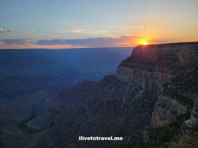
Cross-Country Drive Day 2 – Kingman to the Grand Canyon

Stats of the drive

Second day: Kingman, Arizona to the Grand Canyon National Park (GCNP)

Routes taken: I-40 east to Route 89 north (around Flagstaff) to Route 64 west (at Cameron) to hit the eastern entrance to the GCNP

Departure time: 9AM

Arrival time: 3PM

License plates spotted: 43 states (somehow I suspect the gravity pull of the Grand Canyon had something to do with this success!)

sunrise, Grand Canyon, rim view, Arizona, route 66, route 89
Along Route 89

A simple plan

The trip’s plan included spending an overnight at the Grand Canyon National Park and enjoying the beautiful views. The drive from Kingman to the GCNP was going to be only about 3 hours so we planned for a late start this day. This would give us a break from early starts that would characterize the entire roadtrip.

sunrise, Grand Canyon, rim view, Arizona, route 66

Maximizing the Grand Canyon experience

Since we only had an afternoon and an evening (we would leave early the next morning), we splurged by staying right at the rim of the Grand Canyon. For those who have not been there, if you stay at hotels outside of the GCNP, you have about an hour’s drive (or more) for most of them. So that would be a 2-hr roundtrip in and out lost in driving.

We stayed at the Thunderbird Lodge on the edge of the canyon and got a partial view of the Grand Canyon. It was a spectacular setting despite the view being partial.

Thunderbird Lodge, Grand Canyon, rim view, Arizona
The view from the ground floor of Thunderbird Lodge

Sunset light at the Grand Canyon

sunset, grand canyon, el tovar, arizona, national park
Looking east towards El Tovar

But let’s not forget about Kingman

So I just spent telling you about day 3’s sunrise but did not tell you about day 2’s sunrise…

Being that my body was still on Eastern time, I woke up sometime in the 4AM range. First thinking my options were TV or reading, I promptly concluded that it would be good to get some exercise in even if mild. Also, I figured I should try to see some of the town but driving was the last thing I wanted to do. So, I just went for a 45-min walk which also overlapped sunrise.

Our hotel (a very nice Best Western) was right on historic Route 66 so I got to walk some of it seeing the police and fire stations and a few business. I also walked the streets of a middle class neighborhood right behind Route 66 but dogs would bark and being still the wee hours, I felt it a little rude of me to disturb the peace so I went back to Route 66 – to get some of the kicks the famous song promises!

sunrise, Grand Canyon, rim view, Arizona, route 66
Past glories of Route 66
sunrise, Grand Canyon, rim view, Arizona, route 66
Calling Agent 86!

Now, let’s go on to day 3!

Missed the start of the cross-country drive? Check out the San Jose to Kingman drive!

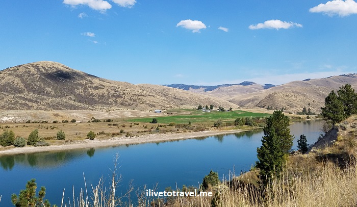
Great Drive Series – St. Ignatius to St. Regis, Montana

While exploring northwest Montana with a friend this past September, we tried to chart different routes as we covered a loop over a 4-day visit to the area.  We started in and finished in Spokane but wanted to minimize taking the same route twice.  We succeeded in that effort save for the stretch on the interstate between Coeur d’Alene, Idaho and Spokane, Washington.  After leaving Bigfork by Flathead Lake, we drove south via Polson to the town of St. Ignatius on Route 93.  We had some options to get back towards Coeur d’Alene and we choose a back route to minimize time on I-90.  This route would take us from St. Ignatius to St. Regis first on Route 200 and then on Route 135.  It was a great choice!

St Ignatius, Montana, Catholic mission, mountains, water tower

The approach to the town of St. Ignatius was impressive!

St. Ignatius, Montana

St. Ignatius was a mission initially established around the mid-19th century in the Flathead Indian Reservation in this part of Montana (the original log cabin still stands).  The current Catholic church dates from the 1890s and is quite impressive in this town of less than a 1,000 residents or so.

St Ignatius, Montana, Catholic mission, mountains, water tower

House in St. Ignatius

The church was undergoing renovations when I went and we got to meet the pastor who was assigned a few years ago to oversee the restoration efforts.  He greeted visitors on the day I went and explained the efforts right up until a family arrived for a baptism when he put on the right gear and proceeded to welcome a little one into the faith.St Ignatius, Montana, Catholic mission, mountains, water tower, Catholic ChurchSt Ignatius, Montana, Catholic mission, mountains, water tower, Catholic ChurchSt Ignatius, Montana, Catholic mission, mountains, water tower, Catholic Church St Ignatius, Montana, Catholic mission, mountains, water tower, Catholic Church, art restoration St Ignatius, Montana, Catholic mission, mountains, water tower, Catholic Church

The Road to St. Regis

After leaving St. Ignatius with its beautiful reminder of times past, of faith, and of those who served selflessly the latter in the former, we got on the road to St. Regis.  It was a beautiful road with many amazing landscapes and photo opportunities that I share here so you can have a glimpse of the beauty of this not-often-visited part of our country.  I leave you with those images and wish to return!

Montana. driving across Montana, road trips in the U.S., Flathead River

Along the Flathead River

Montana. driving across Montana, road trips in the U.S., Flathead RiverMontana. driving across Montana, road trips in the U.S., Flathead RiverMontana. driving across Montana, road trips in the U.S.Montana. driving across Montana, road trips in the U.S.Montana. driving across Montana, road trips in the U.S.Montana. driving across Montana, road trips in the U.S.

Montana. driving across Montana, road trips in the U.S.

Along the Clark Fork River

Montana. driving across Montana, road trips in the U.S.


Scenic drive in Montana from St. Ignatius to St. Regis

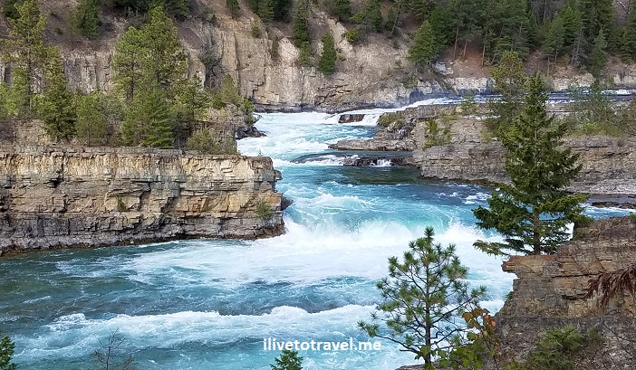
3 Places to See in the Remote Corners of Idaho and Montana

Up in the panhandle of Idaho and the northwest corner of Montana, there is some spectacular, largely unspoiled scenery.  I imagine not many get to see these lands as people focus on Coeur d’AleneBig Sky or Glacier Mountain National Park.  Well, it may make sense that they focus on those places but, if you have the chance, venture off-the-beaten-path.  I did just that simply on intuition, assuming/hoping that the remote corners of Idaho and Montana would deliver.  I was not disappointed.  Lake Pend Oreille, Ross Creek Cedar Trail and Kootenai Falls delivered!

#1 Before Montana: Idaho and Lake Pend Oreille

On my way to NW Montana, we drove north from Coeur d’Alene on route 95 through the town of Sandpoint to take Route 200 around Lake Pend Oreille.  Originally we had planned to go north past Sandpoint to Bonners Ferry and then take U.S. Highway 2.  However, the visitor center in Sandpoint recommended not continuing north on Route 95 but taking Route 200 instead to enjoy the scenic drive along the lake’s shore.   The exact quote was “I don’t why young punks insist of going north to Bonners Ferry”; I was flattered by the “young”…

In any event…  Lake Pend Oreille is the 5th deepest lake in the U.S. and the 38th/39th largest lake in the country.  Interestingly, it became the second largest naval training ground in the world during World War II after the attack on Pearl Harbor – who knew!

Lake Pend Oreille, Idaho's panhandle, map, great drive

Lake Pend Oreille looks like an ear – or a shrimp

The name of the lake means ear pendant in French which makes sense as it looks like an ear on the map.  However, it was named back when the shape was not as evident.  But, a likely explanation I read was that the Kalispeli residents of the area, whom the Canadian traders ran into, did wear ear pendants.

I don’t know what our original planned route would have been like but Route 200 around the lake was right on point. Lake Pend Oreille’s coastline is nice and curvy and there are plenty of pull-offs to stop and soak it all in.Lake Pend Oreille, Idaho, nature, great lakes, driving in the pacific northwestLake Pend Oreille, Idaho, nature, great lakes, driving in the pacific northwestLake Pend Oreille, Idaho, nature, great lakes, driving in the pacific northwest

We were also advised to try The Pantry bakery in Clark Fork where locals make delicious and fresh pastries (and one could pick up something for lunch too).  We did stop and enjoyed apple and cherry pies and bought this phenomenal chocolate pound cake that I enjoyed the rest of the trip!Clark Fork, Idaho, Pend Oreille, great drive in the pacific northwest

#2 Ross Creek Cedar Trail in Route 56

Once we left Clark Fork, the visitor center advisor had also suggested we take Route 56 on our way to get to U.S. Highway 2 as the Ross Creek Cedar Trail park was worth a stop and Route 56 was quite scenic.  Our plan all along had been to get to Hwy 2 (but by Bonners Ferry, if you recall…) to enter Montana so the recommendation would still allow us to do that, so we took it.  Some time after crossing into Montana from Idaho on Route 200, we found Route 56.Ross Creek Cedar Trail, hiking in Montana, exploring western Montana, massive cedar tree

Ross Creek Cedar Trail was a short (1 mile or so) walk through a grove of cedar trees.  The tree trunks were massively wide at their bases.  Some of the trees are 1,000 years old (I found it mindboggling but the forest service website says so!).  It was a nice way to stretch the legs on an easy trail and breathe clean, fresh air!  (Well, as long as you are not close to the vault toilets… what a situation!)Ross Creek Cedar Trail, hiking in Montana, exploring western Montana, massive cedar treeRoss Creek Cedar Trail, hiking in Montana, exploring western Montana, massive cedar tree Ross Creek Cedar Trail, hiking in Montana, exploring western Montana, massive cedar treeRoss Creek Cedar Trail, hiking in Montana, exploring western Montana, massive cedar tree

The drive out of the park along route 56 going north towards Troy was fun as it was not highly trafficked and the scenery quite enjoyable.  Driving north seeing the mountains ahead made for a memorable drive!

Ross Creek Cedar Trail, hiking in Montana, exploring western Montana, massive cedar tree

Heading out of the Ross Creek Cedar Trail park towards route 56

Ross Creek Cedar Trail, hiking in Montana, exploring western Montana, massive cedar tree

Views off route 56

Ross Creek Cedar Trail, hiking in Montana, exploring western Montana, massive cedar tree

Views off route 56

Kootenai River, route 56 in Montana, Kootenai Falls, US Highway 2 in Montana

Entering Kootenai River Country in route 56

#3 Kootenai Falls in Montana

Soon, we reached Hwy 2 and and headed east to get to Kootenai Falls, about 4 miles away or so.  Easy to pull off the road into a parking area next to the trail-head.  It did not take long to see why this spot is so highly recommended as a must-see. The hike itself is not too strenuous but it is not a flat, smooth path.  But before you get there, you will have to go down a few flights of stairs in a large metal staircase that helps cross over the railroad line that goes through the area.

I will let the photos speak for themselves, just know that there are two paths:  one to the main part of the falls and the other to a swinging bridge that serves a a good vantage point to look at the falls.  Do cross the bridge as there is a good vantage point from there too.Kootenai Falls, northwest Montana, Off the beaten path Montana, natureKootenai Falls, northwest Montana, Off the beaten path Montana, natureKootenai Falls, northwest Montana, Off the beaten path Montana, natureKootenai Falls, northwest Montana, Off the beaten path Montana, nature

Kootenai Falls, northwest Montana, Off the beaten path Montana, nature

Some spectacular fishing spot!

Kootenai Falls, northwest Montana, Off the beaten path Montana, natureKootenai Falls, northwest Montana, Off the beaten path Montana, natureKootenai Falls, northwest Montana, Off the beaten path Montana, natureKootenai Falls, northwest Montana, Off the beaten path Montana, natureKootenai Falls, northwest Montana, Off the beaten path Montana, nature

Kootenai Falls, northwest Montana, Off the beaten path Montana, nature

Photo opps galore!

Kootenai Falls, northwest Montana, Off the beaten path Montana, nature

Check out the falls in motion!

Do you have other suggestions for exploring the remote corners of Idaho and Montana ??

Great Drive Series – 17-Mile Drive in California

I have been to San Francisco once or twice for very short visits but have not gone further south than the airport – on this trip I would get to do the 17-mile drive near Monterey and see famous Pebble Beach.  I coupled a short business trip to San Fran with a visit to friends who leave near San Jose, California.  I really had no plans going in but I did want to see legendary Silicon Valley and get a sense for how the home of the likes of Apple, Google and others was.  My friends suggested that beyond that, I should also check out the 17-mile drive and Pebble Beach.  I liked the idea and the rest is history.  Let’s get to that drive but first…

Leaving San Fran – Caltrain!

I left San Fran on a Wed afternoon by taking the Caltrain down for the hour ride to San Jose for $9.25!  Note that the hour ride is for the “express” train that makes less than half a dozen stops between the two cities.  The express only runs at peak times which in the afternoon means from 4 PM until the end of rush hour.  I killed some time at the station to avoid taking the non-express with all the annoyance that that would bring with all the stops.  The 4PM was not packed but was pretty well “attended” with commuters from school-aged kids going home to worker bees heading back home.  The train is a double-decker so plenty of space.  Except I did not find a spot for suitcases so I had to place it on the seat next to me.  Maybe that was better as it was with me the whole time?

Caltrain, train, transportation, travel, San Francisco, California

The only photo I have related to the train… sorry! And the shades were given to me at the conference.

17-Mile Drive and Pebble Beach

I am not a golfer but I knew, of course, about Pebble Beach.  To be honest, I really did not know where it was.  At least I had heard of it.  But I had never heard of 17-Mile Drive.  We left San Jose and drove through eucalyptus forests and passed by sand dunes as we approached Monterey.  Monterey has an awesome aquarium but I preferred to add Carmel to the itinerary so the aquarium will be for another time.  (Read about the aquarium here.)

Pebble Beach, 17 Mile Drive, California, Pacific, Cypress Point, ocean, sea, algae, travel, drive, scenic

The drive through the eucalyptus forest

Starting on 17-Mile Drive

Upon entering Monterey (or its outskirts), we took a left hand turn to enter the route that would take us to 17-Mile Drive.  We hit a gate where we paid $10 for the right to enter “The Drive”.  The drive seems to be in private property, hence they get to charge for driving through it.  It is not a park but the setup looked like one.  While I am grateful -if it is private- that they have found a way to let the public in, I wonder how this choice piece of land came to be private property… an item for research (on a rainy day with nothing else going on…).

map, Pebble Beach, 17 Mile Drive, California, Pacific, Cypress Point, ocean, sea, algae, travel, drive, scenic

The route of 17-Mile Drive

There are quite a few stops along the way by the ocean which is quite nice.  You can get out of the car, eat something, walk on the beach, or watch the sea otters (or perhaps a whale?).

Pebble Beach, 17 Mile Drive, California, Pacific, Cypress Point, ocean, sea, algae, travel, drive, scenic

The Pacific Ocean roaring against the rocks; we saw some seals

Pebble Beach, 17 Mile Drive, California, Pacific, Cypress Point, ocean, sea, algae, travel, drive, scenic, photo

Instead of boring you with the actual shot, how about two of me getting ready for it?

The water is quite frigid so there will not be any swimming but I had to dip my toes just to feel it!

Pebble Beach, 17 Mile Drive, California, Pacific, Cypress Point, ocean, sea, algae, travel, drive, scenic, photo

Into the cold!

Cypress Point

The most spectacular stops were Cypress Point Lookout and Pescadero Point.  The place was first spotted (that we know of) by a European as far back as 1542.  Over two hundred years later, a missionary gave Cypress Point its current name.  Supposedly the cypress tree growing on the rocky point is like 250 years old – they are trying to get it to stay alive until 300 (according to the sign).  Wonder what they plan to do if it gets to 300.  Chop it?  It sure makes for a beautiful sight and an iconic image representing the California coast.

Pebble Beach, 17 Mile Drive, California, Pacific, Cypress Point, ocean, sea, algae, travel, drive, scenic, photo

The Lone Cypress

During the drive we ran into Cypress Point Club and latter the Pebble Beach courses.  What a setting for golf!  Not that I play but if I did…

Pebble Beach, 17 Mile Drive, California, Pacific, Cypress Point, ocean, sea, algae, travel, drive, scenic, photo

Cypress forest native to the area

I did not get to snap any good shots of these so I will leave you with some “sea art” from the Pacific coast:   no one does it better than nature!  From here we went on to Carmel and visited its famous Mission – you can read about that part here!

Pebble Beach, 17 Mile Drive, California, Pacific, Cypress Point, ocean, sea, algae, travel, drive, scenic, photo

Marine vegetation imitates art?

Pebble Beach, 17 Mile Drive, California, Pacific, Cypress Point, ocean, sea, algae, travel, drive, scenic, photo

My favorite shot

It is neat when travel unexpectedly shows you something you had no real understanding of – or perhaps even knowledge of.  This visit qualifies under both – an unexpected enjoyable side trip!

Pin 17-Mile Drive to your travel board!

17 mile drive, pebble beach, california, great drive, Pacific coast drive

Save

Save

Save

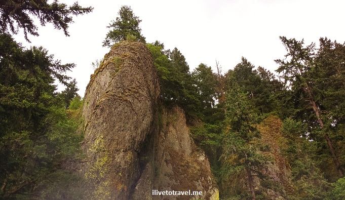
Great Drive Series – Along the Columbia River in Oregon

Oregon has been a place I have always been wanting to go.  When the opportunity to go on a business trip to Portland arose, I was thrilled.  Though I was not able to append a weekend on either end of the business trip to get to explore more, I did have a Sunday afternoon and the hours after office hours to check some of the area.

My favorite part was driving along the Columbia River Gorge.  I had not read up much about the area before going and it surprised to discover there was a gorge along parts of the Columbia River, near Portland.  I discovered it by looking outside my seat window as we were close to land in PDX.  I was very lucky to have picked a window seat (I am a serial aisler) and that it was on the right side of the plane which not only afforded me the opportunity to discover the gorge but also to see Mt. St. Helens and Mt. Adams.  (Clearly, the airplane’s window was a little dirty and, seemingly, so was the air right above – notice the brownish line killing my clear view of the top of Mt. St. Helens).

Mt St Helens, Mt Adams, Columbia River, Columbia River gorge, airplane view, travel, photo, Samsung Galaxy

Mt. St. Helens on the left, Mt. Adams on the right; the Columbia River and the gorge in the middle

Mt St Helens, Mt Adams, Columbia River, Columbia River gorge, airplane view, travel, photo, Samsung Galaxy, Portland, Oregon

Close up of the mountains (and the window smudge!)

Getting to the Columbia River Gorge from Portland was very easy.  Just take I-84 East.  To visit the most famous of the waterfalls, Multnomah, one doesn’t even really have to get off the interstate:  there is a parking area in the middle of the interstate (a rest area) and a tunnel under the lanes to get to the waterfall.

Portland, Columbia River, Oregon, Multnomah Falls, gorge, scenic, nature, outdoors, Samsung Galaxy, photo, travel

At the top of the photo, you can see the rest area

But it is nicer to get off earlier (at Troutdale or Corbett) and then do the scenic route, passing other waterfalls along the way.  The scenery is beautiful.Portland, Columbia River, Oregon, Multnomah Falls, gorge, scenic, nature, outdoors, Samsung Galaxy, photo, travel Portland, Columbia River, Oregon, Multnomah Falls, gorge, scenic, nature, outdoors, Samsung Galaxy, photo, travel Portland, Columbia River, Oregon, Multnomah Falls, gorge, scenic, nature, outdoors, Samsung Galaxy, photo, travel Portland, Columbia River, Oregon, Multnomah Falls, gorge, scenic, nature, outdoors, Samsung Galaxy, photo, travel

The first main stop is phenomenal:  Vista House on the Crown Point Scenic Corridor.  You enjoy great vistas up- and down-river of the Columbia River from this high vantage point.  I wish I had been there for sunrise or sunset (or both) – bet the view would have been even better!Columbia River, Portland, Oregon, gorge, Vista House, nature, outdoors, travel, Samsung Galaxy, photoColumbia River, Portland, Oregon, gorge, Vista House, nature, outdoors, travel, Samsung Galaxy, photo Columbia River, Portland, Oregon, gorge, Vista House, nature, outdoors, travel, Samsung Galaxy, photo Columbia River, Portland, Oregon, gorge, Vista House, nature, outdoors, travel, Samsung Galaxy, photo Columbia River, Portland, Oregon, gorge, Vista House, nature, outdoors, travel, Samsung Galaxy, photo, vista

After Vista House continuing eastbound, a series of waterfalls come before getting to Multnomah Falls, the tallest falls in the state.  There are several trails available to get out and walk.  I reserved my limited time to go up the Multnomah Falls which rises over 600 ft.  Multnomah, falls, waterfalls, Oregon, Columbia River, gorge, scenic drive, outdoors, nature, travel, photo, Samsung Galaxy

I did the round trip up and down in slightly less than an hour.  It is nice they numbered the switchbacks going up but it certainly made me anxious to get to the last one – I’d rather not know how many I have left!

Latourell Falls on the left and Multnomah Falls on the right

Latourell Falls on the left and Multnomah Falls on the right

Multnomah, falls, waterfalls, Oregon, Columbia River, gorge, scenic drive, outdoors, nature, travel, photo, Samsung Galaxy Multnomah, falls, waterfalls, Oregon, Columbia River, gorge, scenic drive, outdoors, nature, travel, photo, Samsung Galaxy Multnomah, falls, waterfalls, Oregon, Columbia River, gorge, scenic drive, outdoors, nature, travel, photo, Samsung Galaxy

Multnomah, falls, waterfalls, Oregon, Columbia River, gorge, scenic drive, outdoors, nature, travel, photo, Samsung Galaxy

At the top of Multnomah!

Multnomah, falls, waterfalls, Oregon, Columbia River, gorge, scenic drive, outdoors, nature, travel, photo, Samsung Galaxy

Yikes, close to the edge!

I do wish I had had time to go to the coast and visit the Lewis & Clark National Wildlife Refuge.  I enjoyed reading the story of Lewis & Clark a few years ago and would have enjoyed seeing where their journey ended where the Columbia River meets the Pacific Ocean.  Next time!

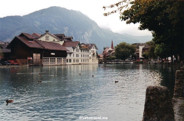
Great Drive Series – A Switzerland Sampler

When I worked in Paris many moons ago for 6 months, one of the neat weekend trips I took was a rather rushed visit to Switzerland.  More than anything, we just wanted to leave France.  Having visited Heidelberg and worked in The Netherlands during that period, we opted to go south:  Switzerland (or Schweiz or Suisse, depending on which language you prefer).

We left work, grabbed our backpacks, and rode to the car rental offices in Paris to get our car.  We decided all this within i a day or two from leaving so had no big plans nor hotel reservations anywhere.  All we had identified was some target cities based on the easiest drive-around route.  This was when the Internet was not yet matured so even if we had had the time we would  not have gotten too much info on what to see and do.  So drive we did.

That Friday night, we overnighted in a French town named Besançon, a town of about 200,000+ residents, somewhat east of Dijon, and not far from the Swiss border for all practical purposes.  The town had an old casino which we thought we’d check out except it was all very smoky and we pretty  much just walked right back out, opting for dinner at some non-descript café before going to our small hotel to rest for the night.

The next morning we crossed the Swiss border where we had to buy a permit to drive in Switzerland.  I am not sure if that is still needed but make sure you find out before driving into the country.  We felt that to aim for Geneva would put us to far west and that we would have to backtrack on the same road to head eastward so we opted for passing on Geneva (much as it is definitely worth the visit).  We drove straight into Lausanne as our first stop though we made it a quick one to get info on the roads (i.e., get maps).  We spied the headquarters of the International Olympic Committee facing Lake Geneva, no doubt paid for by money the sponsors of the Olympics pay the IOC for their monopoly.  It looked like quite a pleasant city to live in, I must say.

Lausanne, switzerland, city, lake Geneva, travel, photo, Canon EOS Rebel

Sitting on the northern shores of Lake Geneva is Lausanne

Since we learned that Bern (Berne) and Interlaken were really the must-sees in the western half of Switzerland (we were not going to have enough time to explore the other half in one weekend AND return to Paris on time to show up at work Monday AM), we decided to not spend more time in Lausanne. The map below highlights in yellow the route we decided out which would take us close to Zurich but with no time to spend there, and would have us exit Switzerland at Basel, thereby minimizing backtracking in our route.

Switzerland, map, route, driving, Bern, Lausanne, Interlaken, travel, tourism

Instead we took off and decided the best route was along Lake Geneva (instead of heading back north of Lausanne and along Lake Neuchatel) where we were rewarded with views of the lake on one side and views of vineyards on the other (who knew!) before turning inland to head to Switzerland’s capital, Bern.  The weather, as you may notice, was not the best for awe-inspiring photography (as you can tell) but the sights were still beautiful.

Swiss, vineyards, Switzerland, Alps, drive, driving, travel, tourism, Canon EOS Rebel

Some of the many vineyards we drove by along Lake Geneva

Swiss architecture, Switzerland, Alps, drive, driving, travel, tourism, Canon EOS Rebel

THE narrowest steps I have seen, right by the road and NO handrail!

clock tower, Switzerland, Swiss architecture, drive, driving, travel, tourism, Canon EOS Rebel

Clock tower

Swiss architecture, Switzerland, Alps, drive, driving, travel, tourism, Canon EOS Rebel

Typical Swiss home along the shores of Lake Geneva

We arrived in Bern and sought the tourist information office – which you could count to be well-organized being a Swiss operation.  And it was!  The young woman helped us find a place to stay in the center of town – nothing fancy needed, just a clean bed and bathroom.  We checked in but immediately took off to our main target:  Interlaken.

The drive to Interlaken (“between lakes”), as the name alludes, requires you to drive along a lake.  The road was curvy and fun to drive.  We arrived at Interlaken and walked around, admiring the beautiful town and setting, with the ice blue waters flowing between Lake Thun (Thunersee) and Lake Brienz (Brienxersee) going right through town.  We found a neat spot to eat at and enjoyed a great late lunch admiring the view.

Interlaken, Switzerland, travel, tourism, Alps, ice cold blue, Canon EOS Rebel

Beautiful part of Interlaken

After some more walking, we headed back to Bern (wishing we had not found a hotel yet in Bern so we could stay at Interlaken instead… ) to have dinner and see some of the town.

Bern, Berne, Switzerland, view, vista, photo, travel, tourism, Canon EOS Rebel

Looking back towards Bern on the road towards Interlaken

The next morning we continued our drive (which took us back past Interlaken; the dreaded re-tracing of a route…) on our way to Lucerne, another Swiss town on the shores of the same-named lake.  We parked, walked around town, had lunch and started the long drive back to Paris.

One thing about driving in Switzerland is that there are never ending things to admire whether they be structures, lake, our mountains. You could say we barely scratched the surface on this beautiful country – clearly there are other great driving routes awaiting but for one weekend’s worth of sampling, I am pretty pleased!


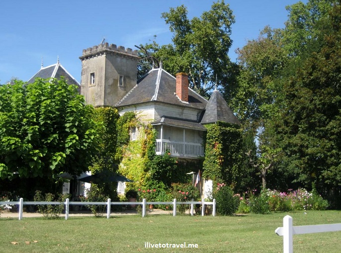
Great Drives Series – Around Bordeaux

I have done a couple of trips into Bordeaux where I have explored the region by car.  There really is no better way to explore the diversity of the region (and its wines!), which may seem at first to be more homogenous than it actually is.  To venture inland, near where Bordeaux runs into the Dordogne is to see a totally different Bordeaux than you may see in the Médoc.  To drive around Sauternes is definitely different than going to Saint-Émilion.

Bordeaux, landscape, vista, France, photo, wine, travel, Canon EOS Rebel, great drive, countryside

Beautiful countryside in Bordeaux

sunflower, Bordeaux, France, travel, photo

Fields of sunflowers dot the landscape in parts of Bordeaux

Both times I went were in the pre-GPS era but that did not make it difficult to drive around.  A good map (and a good map reader somewhere in the vehicle) is all you need to be able to explore this area without too much trouble.

Bordeaux, chateau, signs, driving, France, wine, travel

Plenty of markers/signs help the visitor find their way around!

St. Julien, Bordeaux, large wine bottle, wine, bottle, photo, travel, Canon EOS Rebel

With helpful markers like this one, you know you are in wine country!

One of our stops was the Château Ducru-Beaucaillou where we were taken on a private tour of this grand winemaker (through which I would run the next day when I ran in the Bordeaux marathon!).

Chateau Ducru-Beaucaillou, Bordeaux, Medoc, France, winery, vineyard, chateaux, wine, photo, Canon EOS Rebel

Chateau Ducru-Beaucaillou (I would run right past this spot the next day!)

If you are somewhat interested in wine, there will be plenty for you to do and explore. The town of Saint-Émilion is one of the gems of the region.  Walk around but climb up to the top of the town.  There are cafés up there too and nowhere better to be when the sun sets, glass of wine in hand – of course!

St. Emilion, Bordeaux, French town, France, sign, vines, photo,Saint-Émilion, Canon EOS Rebel

The way to Saint-Émilion!

St. Emilion, Bordeaux, French town, France, sign, photo, Canon EOS Rebel

Always remember where you parked in a new town! In this case, a nice map at the town entrance helped!

St. Emilion, Bordeaux, French town, France, view , photo, Canon EOS Rebel

View from the upper part of Saint-Émilion down to its main square

We enjoyed some of the big (and seemingly more commercial) chateaux but we also loved to more “rural” areas on roads less traveled and discovering the smaller vineyards and winemakers.  Some of the information offices and hotels had displays full of cards of the many chateaux in the area such as the one below.

wine, Bordeaux, France, card, chateau, travel

It was one of these cards that led us to discover a gem of a château in SauternesChâteau Sahuc Les Tours.

Chateau, Sahuc Les Tours, Sauternes, Graves, Bordeaux, France, travel, wine, vin, countryside, travel, photo, Canon EOS Rebel

The beautiful Château Sahuc Les Tours

The owners even sat down with us to share a bottle of their Sauternes and spent a good hour chatting with us about every topic that could concern French and American alike (they spoke excellent English).  Sauternes (in the Graves area), if you are not familiar, produces a sweet white wine bearing the same name made from sémillon, sauvignon blanc, and muscadelle grapes that have Botrytis cinerea (or “noble rot”) which concentrates the sugars.  We got to see the grapes up front as they began to look like raisins.  But don’t let the thought of rot keep you from drinking this wine!

Sauternes,  Botrytis cinerea, noble rot, wine, grapes, Bordeaux, Graves, Semillon, photo, travel, Canon EOS Rebel

Before and after…

That was such a good experience that I returned 7 years later to that chateau – and to my delight, one of the owners was there and, though she clearly could not remember me, realized I really had been there before as I recounted some of the things they had told us the first visit.  Connecting with locals in a real way is one of the rewards of venturing out and exploring this world!

sauternes, grave, Bordeaux, France, winemaker, photo, travel

The friendly owner of Sahuc Les Tours with a delicious bottle in hand

So while this post is about great drives, let’s not forget that this drive is about wine!  Cheers!

wine, Bordeaux, France, travel, photo, Canon EOS Rebel

A beautiful wine in Bordeaux


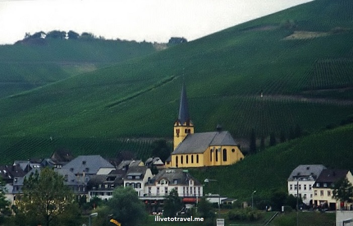
Great Drive Series – Frankfurt to Maastricht

Among the many ways to travel and explore, few things beat driving around yourself, whether it be Tuscany, New Zealand or across the U.S., there is a freedom that comes with being on your own, able to stop at will for a photo, to rest or… to relief yourself (yes, I said it …).

I have done some great drives and I thought I’d start a short series on these drives and, hopefully, hear back from you on your own favorite drives along the way.

Today, I share my drive to/from Maastricht, The Netherlands and Frankfurt, Germany over a dozen years ago.  I was in Frankfurt for business for a few weeks and decided to visit a college friend who was an ex-pat in Maastricht.  I rented my car in Frankfurt and made my way, in about 3 hrs, to Maastricht on the famous autobahn.  The autobahn between some cities in Germany fails to meet the wild expectations we have in the U.S. about fast speeds as there is too much vehicular traffic on some of the routes.  But some parts of the route I took where free and clear just for me.  That and along the Mercedes-Benz upgrade they gave me were the perfect pairing for a FUN drive.  On the outbound leg of the trip, I drove northwest towards Bonn and Cologne (Köln) on the A3 and then west on the A4 past Aachen straight into Maastricht.  I wish I had had time to explore Aachen, having been a residence of Charlemagne and where many Holy Roman Emperors were crowned back in the day.  For that matter also Cologne and Bonn.  So much too see and so little time…

Maastricht, Frankfurt, drive, map, A3, A4, autobahn, Germany, travel

The outbound route I took

On the way back I took a different route based on my friend’s suggestion as the landscape would be much more rewarding.  It was indeed!  I don’t recall the details of the route (which cut at some point across the incredible Mosel River) but maybe someone will recognize some of the locales from the photos and let me know more precisely where I went through!

Germany, drive, church, mountain, river, photo, Canon EOS Rebel, Germany, drive, mountain, river, photo, Canon EOS Rebel, Germany, drive, mountain, river, photo, Canon EOS Rebel,

I highly recommend taking the “road less traveled”.  In this case, not the A3!   Western Germany, near the border with Luxembourg and France, is simply a beautiful place to visit, explore and drive.  Get lost, take your time, and sample this area!


%d bloggers like this: