The Korean Demilitarized Zone, or “DMZ“, has likely kept the Korean peninsula and the world at large out of war for over many decades. From afar, and up-close, visiting the Demilitarized Zone commands respect as a danger zone where, potentially, a mis-step could trigger a lot of non-sense.
The prickly border between North Korea (the DPRK) and South Korea (the ROK) is around 4 kms deep (about 2.5 miles; 2 km on either side of the technical border between the two countries) and 250 km long (160 miles). We mainly visualize an area called the Joint Security Area, or “JSA”, but that is only a tiny -though highly important- part of one wants to see when visiting the DMZ with a DMZ tour.

Planning to visit the JSA in the DMZ
When I began planning my visit to South Korea, as I researched blogs like this one, I learned that it was possible to visit the DMZ and even the JSA. I realized quickly that to get to see the “iconic” JSA, one had to book way in advance and I was perilously close to be too late.
After a lot of digging around, I found a tour company that had capacity on one of the days I would be in South Korea. I am sure the days and times of visiting by the public at large is very tightly managed, hence the difficulty in booking a JSA visit.

In any case, I nabbed a spot on a DMZ tour that included visiting the JSA even if that visit is way too quick (which is what I had read; one barely gets to take a picture on the most iconic photo spot in the JSA). Keep reading to find out what happened…
The DMZ’ JSA (acronyms R us)
Neither country has jurisdiction over the JSA, though it includes territory from both. There are meeting rooms that cross the border where representatives of both sides can meet. We saw earlier in 2018 the leaders of each Korea cross the border into the other country’s border.
That momentous event took place in the JSA, which is also casually referred to as Panmunjeon, where the armistice was signed in 1953. If I understood correctly, the United Nations Commission has been responsible for the JSA.
Up until 2018. Due to the recent developments warming the chill between the two countries (and the U.S.), it has been decided to convert the JSA from a major military and command center to a tourist attraction (??). In the fall of 2018, guard houses within the JSA were to be removed and the zone will become a free movement zone, meaning that people who are allowed into the JSA, technically can move freely between the two Koreas in the JSA.
And here is where my plans went awry… The project to remove guard houses and do some other changes to the JSA were not done by the day my tour was supposed to happen so that portion of the tour was cancelled by the authorities that control visits to the area. BIG bummer…
Visiting the DMZ – the approach with a DMZ tour
Well, for this curious traveler, seeing North Korea from across the border was a priority. Not that it would be a big a-ha or anything but, I just had to see it! As one travels the so-called Freedom Highway (route 77) out of Seoul along the Han River, right as one passes Gimpo on the way to Paju, one gets to get the first glimpse of North Korea. At that point, the demarcation line (or, the border) actually runs through the water. Not much to see.
Except, I noted the waters were empty on what seemed at nice day. Later I learned that those waters are a no-enter zone as a small slip by someone could create an incident. Made sense.

As we headed to Paju, I noted the security fence just next to the highway to prevent anyone entering (or leaving) South Korean land and entering the water. It was definitely not just a yard chain link fence! And there were guard houses at very frequent intervals (not sure what the distance between them was). They looked empty but the tour guide indicated that at 8 AM the guards leave them.
In essence, they are watching the edge of the water at night only. The waterway soon fully becomes South Korean territory and we crossed it.

We were not yet in the DMZ though. That was next in our DMZ tour.
Entering the DMZ at Imjingak Park
To enter the DMZ, visitors need to switch to buses that are allowed to operate in the DMZ at Imjingak‘s “tourist site.” We went to an area with an observatory (elevated point from which to view North Korea), a coffee shop, a souvenir store, and a large parking lot area for buses to park to drop off and pick up visitors.
And a small amusement park/carnival which felt out of place given the serious business that gives rise to needing a DMZ… Weird. However, this is a bit of a mis-read of the place. This park was created to console families that were divided when the border was closed, as a place to get as close as possible to their North Korean families and homeland.


First viewing point: Dora Observatory
After entering the DMZ, we headed to the Dora Observatory on Dorasan (Mt. Dora). It was a short uphill walk to get to the observatory from which we could then look through a high platform/plaza towards North Korea. The free standing “binoculars” were very helpful to get a better view of North Korea.

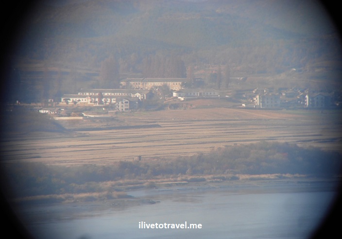
One can see one of the famous propaganda villages built by North Korea to ‘impress’ the southerners – it was a fake village. It is supposedly the closest a visitor to the DMZ gets to North Korea. This stop is close to both the third tunnel and the Dorasan ghost train station (keep reading below…).

From this observatory, one can see the North Korean town of Kaesong, the largest community visible to me during me DMZ visit.

3rd tunnel under the demarcation line
North Korea secretly built tunnels that would allow it to “pump” 30,000 soldiers per hour into South Korean territory. Everyone believes it was to support an invasion of South Korea at some point. The tunnels started getting discovered thanks to a northern defector who informed the south in 1974 that the DPRK was building this tunnel but uncertain of the precise location.
So the south buried 107 PVC pipes into the ground full of water until one of them pointed the spot under which there was a portion of the tunnel in 1978. The South Koreans ended up discovering 4 tunnels (are there more??) over the decades.

In my tour, we visited the third tunnel, very close to the Dora Observatory. by using an access tunnel built by the south to get to the North Korean tunnel (which is 2 m wide by 2 m tall). The access tunnel is a little wider than the North Korean tunnel though often shorter, hence why everyone is given a hard hat to wear upon entering.
The end point on the North Korean tunnel that a visitor gets to is a wall that blocks any potential use of the tunnel by the North to enter South Korea (there are two further walls behind the one facing the visitor). To get to the end point, the visitor descends about 300 m. It is steep and long.
And the way back is all uphill – no elevator down here! This walk down takes the visitor to 73 m (240 ft) under the surface. At this end point, the visitor is within 170 m of the demarcation line above ground – the closest the visitor gets to the border between the two Koreas.
Displays outside the tunnel help one learn more about the tunnels but most tours rush one through everything so snapping a quick few pictures of the explanatory displays is key so, at least, one can read about it later.

I’d give the tunnel a thumbs-up in terms of something that really conveys how serious the business around here was, even if now it is getting crowded by tour buses.
Train station to nowhere (yet)
The Dorasan train station, right outside of the DMZ on the South Korean side, is a highly clean and modern station recently built to eventually reconnect by train the south to the north (as it used to be a long time ago).

At some point around 2007-8, using the existing rail line that goes now by this stations, a train ran to take raw materials from the south to a factory set up in the North Korean town of Kaesong as a form of collaboration between the two Koreas. That ended as relations went south (pardon the pun).
To run the factory, though, South Korea also had to transmit electricity over power lines built for the purpose. One actually can tell where the demarcation line (otherwise invisible/unmarked) runs by noticing when the power towers change colors: the painted towers are in South Korea, the unpainted ones in North Korea.
In any case, the Dorasan train station was built as a sign of the hope that the two Koreas will re-unify. The hope would be to run the first train service from Seoul to Pyongyang, whenever the political situation allows.

While it seems to be mostly a curiosity to visitors and a “why bother visit”, it seems to go beyond that to South Koreans and, for that, it is worth seeing it to understand it. The South Korean tour guide spoke wishfully of the day when a South Korean could travel from Seoul to Paris by train, a la Trans-Siberian train (or, connecting to it).
They seem to dream of being connected by land to the rest of the world. That, sadly, requires going through North Korea yet the southerners are not shy about their hopes as this map at the Dorasan train station shows!

Final observatory – the Odusan Observatory
Our final stop was offered a good view of North Korea, at this point, across the Im Jin River, leading to the West Sea and connecting also to the Han River (which cuts Seoul in half further south). It was a large, multi-story, and modern facility that felt empty except for us tourists meandering about. They must host events or something.

In any case, the viewing platform is large and has free, standing binocular stations, as did the Dora Observatory. Using a camera on the binoculars allowed capturing some of the details of the North Korean villages, including spotting the mandatory King Il-Sum Memorial every North Korean village must have.


A map shows what one is looking at on the North Korean side.

The view from this observatory is more beautiful due to the water. Also, because it also offers an interesting view when one looks the opposite way, towards Seoul. High thumbs up for this site!


And so ends my visit to the demilitarized zone. Visiting the DMZ is doable on one’s own but I assume with planning to understand the ins and outs of getting there, how to move around in the area outside of the DMZ, and booking spaces in the DMZ-managed buses. I certainly preferred booking a DMZ tour because it just made things easier.
In any case, it was incredible to see this symbol of the power plays between the big powers since the days following the end of World War II. And a sensitive spot on Earth that could have (and still could, I suppose) trigger a nasty war. I hope not as much for re-unification but for freedom for the North Koreans…
Save this image to your travel board!!

Leave a Reply