Hiking in Nepal: To My Turning Point – Deboche (Day 4)

After a restful and relaxing day in Namche Bazaar, it was time to hit the “road” on the trail to Everest Base Camp for the last leg of my trek before turning back.  As I explained in an earlier post, I was shy a few days in my vacation bank so I would not be going all the way to Everest Base Camp on this trek, much to my chagrin.  This day, day 4 of the trek, would take me past colorful and charming Tengboche with its beautiful monastery to super tiny Deboche.  This day of hiking would take me to the highest altitude I would reach in this trek, a hundred or so meters under 4,000 m (or some hundred feet or two under 13,000 ft.), nothing terribly high in comparison to my climb of Kilimanjaro a couple of years before.

This day would start by us climbing up and out of the half bowl that is Namche Bazaar, past the interesting local history museums, and the great viewing point I described on the day 3 post.  And we could also see in the distance the two hanging bridges we had crossed on our way to Namche Bazaar.

Nepal, Everest, Lhotse, ilivetotravel, monument,Himalayas, Everest, EBC, mountains, photo, Samsung Galaxy

Looking back at the spot from day 3 from here we saw Everest

Nepal, Everest Base Camp, trail Tengboche, ilivetotravel, Himalayas, Everest, EBC, mountains, photo, Samsung Galaxy, hanging bridges

The hanging bridges that were so much fun to walk across

Then we skirted the side of some mountains on a beautiful and changing trail that offered us a new and closer view of Mt. Everest and Mt. Lhotse than the prior day’s.  We walked past a stupa or chorten honoring the sherpas of Everest which, besides being a beautiful memorial to these individuals, made for a great foreground to the photo of Mounts Everest and Lhotse that I show below.  A photo which, by the way, also shows my favorite mountain, Ama Dablam, on the right.  This specific view may be the most beautiful view point of my entire trek.  Surreal to the max!

Stupa, chorten, sherpa, Himalayas, Nepal, EBC, trail, Everest, Tibetan, design, colorful, Lhotse, Ama Dablam, Samsung Galaxy

Headed towards the stupa with the best backdrop of the trek!

Stupa, chorten, sherpa, Himalayas, Nepal, EBC, trail, Everest, Tibetan, design, colorful, Samsung Galaxy

Detail of the stupa honoring the sherpas, looking like a Himalayan wedding cake

Stupa, chorten, sherpa, Himalayas, Nepal, EBC, trail, Everest, Tibetan, design, colorful, Samsung Galaxy

Beautiful and colorful detail of the stupa

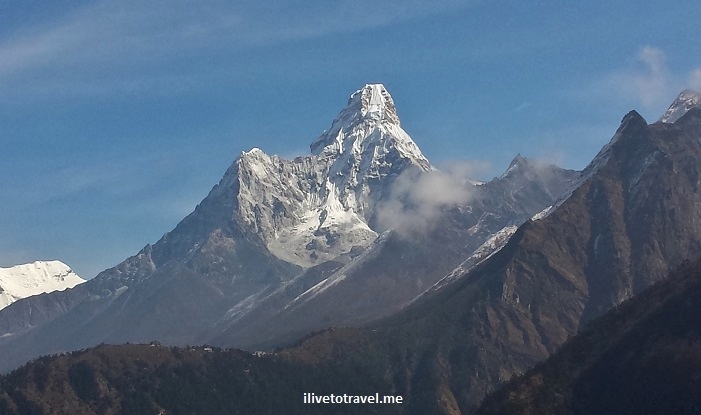
Later on we had the best view on this trail of my favorite mountain in the area:  Ama Dablam.  It looks like it is a person (a mother, perhaps?) with two extended arms covered by flowing robes, welcoming the trekker.  Pretty darn majestic.

Ama Dablam, Everest trail, hiking, Nepal, Himalayas, mountain, peak, Everest Base Camp, majestic, Samsung Galaxy

Majestic and grandiose Ama Dablam

Of course, as we did every day a couple of times, we stopped for tea at a tea house.  Mint tea or lemon tea – I could never decide which was my favorite.  Sometimes one, sometimes the other.  Both the tea and the rest were most welcome but also the time to soak in the landscape around us, the charming architecture of the local buildings simple yet full of color, and just to sit and chat with fellow trekkers while soaking some sun.  A great way to recharge batteries and engrave the sights into my memory bank…

tea house, Himalayas, Nepal, Everest, EBC, Tibetan, architecture, tea, break ,trekkig, hike, Samsung Galaxy

I loved admiring typical Tibetan architecture during tea time and while walking the trail

tea house, Himalayas, Nepal, Everest, EBC, Tibetan, architecture, tea, break ,trekkig, hike, Samsung Galaxy

Lemon tea, anyone?  One or two glasses…

tea house, Himalayas, Nepal, Everest, EBC, Tibetan, architecture, tea, break ,trekkig, hike, Samsung Galaxy

Typical outdoor area of a tea house with the universal plastic white chairs

The team guides and our lead guide discussed whether to make the push for Tengboche (which involved a serious climb) to have lunch there, or to stop short of the climb to have lunch and rest beforehand.  They decided that we would eat lunch before the climb.  I was torn.  On the one hand, the sooner we got to Tengboche, the sooner the hardest part of the day would be behind us and then lunch would feel more lackadaisical (I am all for NOT procrastinating).   I also would not be doing the hardest part of the hike on a full stomach if we had kept going before having lunch…  But, on the other hand, it would delay eating lunch by a good bit.  So, I didn’t mind whichever way they decided – I trusted they knew best what made the most sense for us as a group based on how we were doing – and perhaps other factors (weather?).  In hindsight, having seen Tengboche, I think the spot by the water where we stopped for lunch was perfect for rest and recovery prior to the climb.

Nepal, Himalayas, Everest, base camp, EBC, food, Khumbu, Samsung Galaxy

Part of our lunch – soup and rice!

Nepal, Himalayas, Everest, base camp, EBC, Khumbu, Samsung Galaxy

Toilet in a very scenic place at lunch (you can thank me later for not putting a photo of the inside…)

Overall, that day we would cover about 4 miles (6.5 km) and we were expected to be on the trail for about 6.5 hours.  The most exciting part of the day was when we came to the top of a slope to find ourselves on fairly flat ground looking at the Tibetan Tengboche Monastery through the foggy afternoon.  It was not only a beautiful sight but very surreal.  We walked up the steps hoping someone would come meet us and let us enter it as it looked totally dead to the world.  And, sure enough, someone came to open the doors and invited us in.

Tengboche, monastery, Himalayas, Nepal, Tibetan, color, Samsung Galaxy

Entrance to the monastery (more pix on the next post)

Tengboche, monastery, Himalayas, Nepal, Tibetan, color, Samsung Galaxy

Lots of color and detail

Tengboche, monastery, Himalayas, Nepal, Tibetan, color, Samsung Galaxy

We entered the main prayer room but no photos allowed – and I respect that

Tengboche, monastery, Himalayas, Nepal, Tibetan, color, Samsung Galaxy

You better follow these rules – especially no kiss!

Once we left the monastery, a short walk down from it, we stopped at a tea/coffee house (what else, of course!) before embarking on the short last hour (or less) to our stopping point for the night in Deboche.  With the hardest part of the hike for the day over, it was very enjoyable to kick back and sip away!  Ahh…

Once we got to Deboche, the teahouse was one of the sparsest, most austere of the teahouses I stayed at or visited in this trek.  Being that we were at a higher altitude, it was colder too.  The teahouse only had one tiny stove in the center of the dining/living room (as do most teahouses) which was not irradiating as much heat as most of us wished it had.  I definitely stayed dressed more warmly, even through dinner, as I tried to keep by body heat in me.  We sat around the room with tissues close at hand to dry our noses (a common condition at this altitude and climate) – and drank hot tea until it was time for dinner and the eventual turndown for the night, always a welcome moment to catch our rest!

Deboche, trail, teahouse, tea house, Himalayas, Everest, base camp, Nepal,EBC

View towards the trail from our room in Deboche – very rustic spot

Deboche, trail, teahouse, tea house, Himalayas, Everest, base camp, Nepal,EBC

The rooms were basic but who needs more? Except heat…

Deboche, trail, teahouse, tea house, Himalayas, Everest, base camp, Nepal,EBC, dung, stove

Yeah… heating was very limited and crowds formed around the stove

The evening was nothing short of frigid, frankly.  There were two toilet rooms, one upstairs and one downstairs. But the one upstairs was a Western toilet with a tank that would not fill – so not flushable without a bucket of water.  I found it more effort to flush it so, in the middle of the night, I would walk down the very steep staircase to the non-Western toilet room, though by doing so I had to walk further in the cold of the night and not only freeze but also wake up a little more because the journey took longer…  The little journey was all indoors but, trust me, it was FRIGID; not sure there was much of a difference between inside and outside when it came to temperature.  Thank goodness, I had the right sleepwear and, more importantly, the right sleeping bag to get back into a re-warm up!!

Deboche, trail, teahouse, tea house, Himalayas, Everest, base camp, Nepal,EBC, Olympus

Yeah, that’s our ice-covered window in the morning…  Yes, it was THAT cold.

The next day, my direction would change:  a few of us would be turning back to return to Lukla for the flight back to Kathmandu as our time on the trail to Everest Base Camp would end at Deboche…  The next morning, as we got ready to leave, it was very hard to leave the rest of the group with whom we had spent the first few days on the hike (and the days before working to help build a school in the village of Kumari).  It was a great group of people motivated by the desired to improve the lives of children in Nepal, and who enjoy travel, exploring, and the great outdoors.  That next morning (day 5) we packed up, had breakfast, and went outside ready to go our separate ways.  We posed for one picture which ended up, unfortunately, somewhat blurry and the five of us (one of these being our great guide, Chandra) began our journey back to Lukla to catch out flight to Kathmandu thus starting the end of our time on the amazing Everest Base Camp trail…  While I did not go to Everest Base Camp, I got to experience the best of Nepal:  the people, the architecture, the views and that was all well worth it.


Want to start at the beginning of this trek?  Here is day 1.  Want to know what else I did on this trip other than the hike on Everest Base Camp, check our work to build a school in Kumari here.


Pin this beautiful image to your board!

nepal deboche, tengboche to deboche, everest base camp trail

The view on the way to Deboche via Tengboche: Mount Everest!

Postcards from Iceland: Dalvík

Dalvík, in the north of Iceland right at around 12 o’clock, is a small town of about 1,400 inhabitants on the western side of the Eyjafjörður fjord.  We drove through this fishing town on the way to our base in Akureyri as we rounded the peninsula where Dalvík sits on route 76 going east after visiting Hólar earlier that day.  Route 76 is not part of the famous ring road.  It is a very scenic road hugging the coastline and passing through a couple of charming small towns (Siglufjörður and Olafsfjörður) – a drive I would recommend.

We enjoyed some of the views around Dalvík and here I share some of my favorites.  What do these images remind you of?

Dalvik, Dalvík, Iceland, fjord, Eyjafjordur, fishing town, mountains, boats, churches, Canon EOS Rebel, photo, travel

Incredible landscape around Dalvík and across Eyjafjordur.

Dalvik, Dalvík, Iceland, fjord, Eyjafjordur, fishing town, mountains, boats, churches, Canon EOS Rebel, photo, travel

Dalvik, Dalvík, Iceland, fjord, Eyjafjordur, fishing town, mountains, boats, churches, Canon EOS Rebel, photo, travel

Fishing and fish processing are the key industries in Dalvík

Dalvik, Dalvík, Iceland, fjord, Eyjafjordur, Dalvíkurkirkja, fishing town, mountains, boats, churches, Canon EOS Rebel, photo, travel

Beautiful church (Dalvíkurkirkja) that must almost get lost in winter with it being white!


Dalvik, Dalvík, Iceland, fjord, Eyjafjordur, fishing town, mountains, boats, churches, Canon EOS Rebel, photo, travel

What seemed to be the main church stands out well against the mountains around the town


——– More on Iceland ——–

My itinerary for my week visit to Iceland

A stroll around Reykjavik

Hallgrímskirkja Church in Reykjavik

Þingvellir:  Where History and Nature Meet in Iceland!

The Blue Lagoon

Goðafoss:  The Waterfalls of the Gods

A Northern Town:  Akureyri

Whale Watching

Iceland’s South Shore:  The Dyrhólaey Peninsula and Vik

Photo of the Week – The Alps of Transylvania

This scene was what we were rewarded with after arriving at the Cabana Curmatura in the Transylvanian Alps in Romania and hiking on for another hour.  I dream of returning to amazing Transylvania.  Too bad people’s only notion of it is the legend of Dracula:  there is SO much to enjoy and explore there!

Romania, Transylvania, Transylvanian Alps, hiking, nature, outdoors, travel, photo, Canon EOS Rebel

11 Experiences to Have in Puerto Rico

Because I lived in Puerto Rico for 15 years, I often get asked about what to do and where to stay in this beautiful island.  Of course, these things depend on the type of vacation one is looking for, one’s general preferences, etc. but I can usually provide a varied list of recommendations so others can then pick and choose what sounds good for them.  I will share here the recommendations I have for someone wanting to experience Puerto Rico.  Feel free to ask questions!

Take part in the fiestas patronales (patron saint feasts)

Each town in Puerto Rico has its patron saint.  Around the feast day of the saint, the town has a “fiesta patronal” with a lively parade (heck, everything is lively in Puerto Rico!), music, games, artisans, and food and a very lively atmosphere!  Find a piragüero to make you a piragua (shaved ice with your favorite flavor syrup on it!).

fiestas patronales, patron saint, puerto rico, festivals, music, entertainment, trave,

(Source: www.latinamericatoday.net)

Enjoy Luquillo’s beaches

The beaches of Luquillo, along with Rincón‘s on the west coast, are some of the best on the island.  Luquillo is due east of San Juan and along the way one can stop at the food kiosks off the main road.  These kiosks used to be “huts” but, along the way, the government decided to build them better structures.  I don’t know how many there are but probably over 50 of these eateries.  Stop and taste some of the different foods and maybe a cold beer!

If you feel like it, drive further east to the town of Fajardo.  You can visit its old lighthouse “Faro de las Cabezas“.  You can also drive to the former El Conquistador Hotel (it seems to change name every few years so I stick to the original which everyone knows there) which offers great views cays and the sea below.  It was a very famous hotel in its heyday before it went into decay in the 1970s.  It has been resurrected a few times and it is currently a hotel open for business.

Visit the world’s largest single dish telescope

Made even more famous by the Jodie Foster movie, Contact, and the James Bond movie, Golden Eye, this observatory, built in 1963, is famous for being the largest single dish telescope in the world.  Its diameter is 1,000 ft and it is impressive to see it firsthand, nestled in a small valley.  When I went many years ago (when it was being run by Cornell University), there was a recording playing at the observation deck describing the observatory.  It is from this radio observatory that a message was sent in 1974 by SETI to anyone out there listening that Earth existed and was populated by us.  “Look at me!  Look at me!”  (Like I want angry or scary aliens being alerted to our existence…)

radio, telescope, largest radio telescope, arecibo, puerto rico, wonder, science, SETI

(Source: www.naic.edu)

Go off the mainland to Vieques and Culebra

If Puerto Rico is small, Vieques and Culebra are even smaller but they both offer a nice getaway to a more remote part of the island group.  Vieques was the former location of a U.S. military base so part of it is not as developed as you would expect since the closure of the base is relatively recent.  But I hear that it has been developed smartly.  I have not been to Culebra and, from what I gather, it is less developed.  Either would be great for R&R!

Go under in the Cuevas de Camuy

The caves (or is it more accurate to say “caverns“? some day I will study the difference…) of the Río Camuy, just west of Arecibo, are definitely worth a visit (60 mies or so west of San Juan but miles in PR do not equate easily to time – lots of traffic!).  Due to the proximity to Arecibo, it may be worth combining this visit with the radio telescope since the latter is a fairly quick stop.   The Río Camuy, it may surprise many to know given the smallness of the island, is the world’s third largest underground river.  The river has carved these caves (about 10 miles of them, very little of it accessible to the public) from limestone and you can visit them and ride in them – no worries, the assumed half a million resident bats are likely asleep during the daytime.  But if you go, go early as they stop letting people in after a daily quota has been met (1,500 visitors last I checked).

Visit the pearl of the south:  Ponce

Cross the island from San Juan to Ponce (an hour plus drive) via a scenic drive, and visit the “pearl of the South.”  Ponce is named after the first governor of Puerto Rico:  Juan Ponce de León and later explorer of what became Florida.  Ponce is Puerto Rico’s second largest city.  It has a totally different feel than San Juan’s metropolitan area:  a slower pace, and even the climate is different being a little drier.  Its art museum is well done and its old fire station (Parque de Bombas) is very picturesque.  Both were the target of a special field trip from my high school for the freshman class every year (only an hour plus from San Juan but THAT is considered a LONG trip in this small island!).

Ponce, Puerto Rico, fire station, parque de bombas, red, travel, photo

Ponce’s Parque de Bombas

Explore Old San Juan 

Founded on 1521, there are not enough words to describe how unique Old San Juan is.  Only Havana is competition for OSJ, I hear.  It is the oldest city in the United States, pre-dating St. Augustine by a few decades.  Its cobblestone streets, its beautiful multi-century old buildings (built before anything was built by Europeans in the continental U.S.), and its plazas make this a true jewel of a town.  I appreciate it a lot more now that I no longer live there and have seen more of the world – beats a lot of old towns I have seen.  (Check out my post about OSJ here.)

As a kid, my Dad used to drive us up the hill to enter the old quarter, then along the north coast (with the shantytown La Perla down below the city wall), into the heart of old San Juan to then drive through the old San Juan Gate (a sea-facing gate in the city walls).  Right after going downhill through the gate, the road turned immediately to the left but my Dad used to pretend we were going straight into the water, a thrill ride that I fell for every single time!

Puerta de San Juan, San Juan, Puerto Rico, city walls, fortifications

This is where the gate met the water (Source: www.topuertorico.org which offers great tips)

This gate is the last remaining gate along the city’s walls.  This gate is now pedestrian only and the left turn now takes you down a pleasant walk down the Paseo La Princesa (site of a former jail!).  The city walls are incredible and are preserved along the waterfront but not the inland part.  You can explore these by walking into a garita (guard posts) where Spanish soldiers used to keep watch for foreign invaders and pirates.

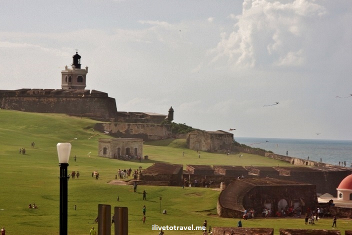
The crowning pieces of Old San Juan are the fortresses of San Cristóbal and San Felipe del Morro (El Morro).  The latter is more imposing but the former is also worth a visit.  Do take a tour when you visit so you can grasp how incredible these structures are due to their age, their construction and their history.  The field in front of El Morro is great for a picnic or fly to kites as you look out on the Atlantic Ocean.  I loved going there as a kid.

El Morro, fortress, San Juan, Puerto Rico, fields, kites, Caribbean, view, vista, photo, travel, Canon EOS Rebel

Great fields facing the ocean (note the kites and the city walls) in El Morro

There is a cemetery at the foot of the city walls of that field but, be careful if you decide to go to the cemetery…  visitors are easy prey in this important cemetery in San Juan.  I will not keep expanding on all there is to do in OSJ (there is a LOT to see!) but there are small museums, art galleries, bars, etc.  Just walk around and explore!

See La Parguera’s bioluminescent bay in the southwest

This bay in the southwest town of Lajas is a unique place.  The thing to do is to get in a small boat and go into the bay at night.  When the still waters are disturbed, the microorganisms that live in the bay glow.  I have actually never gone but it is famous.  When I return to Puerto Rico some day, this is on my list of things to check off!

Experience Loíza aldea

Loíza is a coastal town east of San Juan that seems to have preserved more of the African heritage of the island than the rest of the island.  Stop and try any of the local restaurants / stands and try “salmorejo” (crab dish) or any of the fried foods!  This is definitely off-the-beaten path for visitors.

Drive the mountain towns and see their main plazas

This is my favorite thing.  Puerto Rico is made up of 70-odd towns, each with a center following the traditional Spanish colonial pattern of a main plaza with the town hall on one side and the main church on the opposite side (the other two sides were houses of better-off families back in the day).  Though they sound very similar, each is quite unique and it is fun to visit and see the differences.  Some of the towns are on the coast but the center of the island is mountainous so visiting the inland towns also has the side benefit of driving around the mountains and tropical forests of the island.  Of course, the main plaza in the capital city, San Juan, is very nice but others compete favorably!  Though I have never visited it, I hear Guayama‘s is one of the prettiest.

Porta Coeli, San German, Puerto Rico, church, pueblo, travel

Vintage photo of the Porta Coeli church in San Germán

Go tropical in El Yunque

The mountain of El Yunque east of San Juan, past the airport is actually not Puerto Rico’s tallest point but it is its most notable one as it is quite standalone in comparison to Cerro de Punta (the tallest point in the island at around 4,400 ft).  It is neat to visit as it allows you to see tropical flora at its best.  My favorite are the gargantuan ferns.  You can also get off at the waterfalls and climb around or get in the water.  It is a neat visit, especially if you are headed to the Luqillo beaches or the food kiosks!

There are other neat places to see and visit (e.g., the Bacardi distillery!) but I did not want to write my favorite 111 things to see and do, so I chopped off a digit (not a finger!) and kept it to 11.  Please feel free to ask any questions if you are planning or thinking of a visit to Puerto Rico!

Photo of the Week – The Mountains of Utah

Ah, this picture really makes me long for winter (or a trip to the southern hemisphere where IT IS winter!).  Taken many years ago while I skied awesome Alta, I long to return to those wonderful slopes and setting.  I need to ski next year as I missed this season and I also have Europe in my sights for a ski trip…

Are you a ski fan?  What is your favorite place to ski?  Where do you want to go ski?

Alta, Utah, ski, mountains, vista, photography, freedom, sports, outdoors, photo

Criss-crossing the southern island of New Zealand

Besides flying into and out of the country and riding the TranzAlpine train, buses (or coaches) were my main mode of travel. I was surprised that trains were not talked about much in my readings about how to move about the country but it seems buses are the main way to get around (outside of driving).

Backtracking a little, I did not sign up for a standard guided tour but instead bought a package of transportation and accommodations based on the places I wanted to visit. The agency that helped me basically ensured the places were sequenced in a logical manner and handled the synchronization of schedules when connections were required or when special linkages to other events were needed. The package also included a couple of main attractions (like the ferry ride through Milford Sound). I really liked the idea of an independent tour, as they are called, since I wasn’t looking forward to the “confines” of a guided tour nor of driving around solo.

The “Bus/Coach Experience”

I was not sure what to expect from taking a bus around and in between towns. I was not expecting a regular public transportation bus (as I know them in the U.S. and Europe) but also was not expecting a major tour bus type. These inter city type of buses (InterCity seems to be the largest bus company around but there are others affiliated with tour companies) pretty much go everywhere and are fairly comfortable. Many will have a restroom (or “toilet”) on board and, if not, they will make frequent stops every couple of hours or so for nature breaks, food breaks, and even some photo opps. The drivers for these buses will even do some narration of what you are looking at or going through which was a very nice surprise so that you could understand better the land you are observing. Some of these drivers were a veritable fountain of facts and knowledge! The buses were also on time and some even picked you up/dropped you off at your hotel. In researching the options, there were buses that seemed to be focusing on college-aged tourists – I sensed as much and stayed away from those as I am well past that age. Make sure you understand the focus of any bus company you choose!

sun light ocean, New Zealand, travel, vista, view, sea

Early morning view of the Tasman Sea from the southern island coastal road

Following a circuit around the south island of New Zealand

Another curious thing about doing an independent tour and using the bus system to get around in the south island is that, more likely than not, you are really following a circuit that goes something like this with variations possible: Christchurch, Greymouth, glaciers, Queenstown, Milford Sound, Te Anau, Dunedin, and back to Christchurch. Some of the variations include the Catlins, Invercargill, Stewart Island and a few other places at the very south and very north of the island. (I didn’t do the same type of travel in the north island so I am not as familiar with what a good circuit might be there.)

New Zealand, driving, roads, travel, explore

Nice roads on New Zealand’s southern island

The neat thing for me was that I began to run into the same people at different stages of the circuit (people who were going counterclockwise on that circuit; the opposite direction is also possible!). Sometimes we would be in the same bus 2 or 3 places in a row. Sometimes we broke the sequence only to reconnect later in the trip. It took at least a couple of times of coinciding before really chatting them up. And I actually enjoyed running into the same people later in the trip. Grace from NJ, Chris from London, the Lees from Hong Kong, a couple from Delhi, etc. were some of those folks I ran into a few times. I also did meet other folks whom I only saw at one spot but got to chat or hang out (Ben from Tamworth and Ryan from Melbourne).

New Zealand, southern island, lake, mountains, snow, road, travel, nature, outdoors

One of the most majestic segments of the circuit – I wish I could have sat there for a few hours!

Finally, because of the various stops the buses make, you get to see a couple of smaller towns even if for a short 30 minute walk. We are talking small towns (the largest I reckon was about 4,000 people) so 30 minutes gets you at least a peek at the town center which is better than a drive-by. If you like seeing small towns, clearly driving around would be better as you can decide how long to stay somewhere but I enjoyed seeing places like Wanaka (on the shore of Lake Hawea and somewhere I would stay instead of Queenstown if I ever return!), and Hokitika near Greymouth.

Wanaka southern island New Zealand lake mountains travel nature outdoors explore Canon EOS Rebel

The town of Wanaka by the lake of the same name was peaceful and in an incredible setting

So, among the various good ways to travel the country, the bus system gets a thumbs up. And you will never be a total stranger to everyone while going around NZ!

New Zealand – Traveling from Christchurch to Franz Josef

In order to get to the village near the Franz Josef glacier on the west coast of NZ, I had to take a train across the mountains in the center of island (which are called unofficially the southern Alps, hence the train is called the Tranz Alpine train).

This train cuts through the plains of Canterbury where Christchurch is on the eastern side of the southern island and then climbs up to Arthur’s Pass before beginning the descent towards Greymouth, a small town on the western coast where I connected to a bus that would then drive me south to Franz Josef village.

Canterbury mountain landscape in New Zealand's Southern Alps

View of the Canterbury terrain

The views were spectacular along the route.  The train had a viewing platform from which one could take pictures without the glare of the train window – but only if one was willing to freeze in the cold wind that hit the platform.

Western side of the island from the train (after crossing the southern Alps of New Zealand)

Western side of the island from the train (after crossing the Southern Alps)

The train ride was very comfortable and made a stop or two where we were allowed to get out and stretch our legs.  The train ride took about 4.5 hours.

The bus ride was also very interesting.  Bus rides here include the driver providing commentary that is quite good for a tourist.  The bus also makes several stops along the way not just to pick passengers but at some scenic spots for pictures or to take in the view.  It also makes one or two stops depending on the route and duration for people to eat something or go to the local supermarket.  This made the trip quite comfortable as one always had access to food and restrooms!  These, I learned on my next trip in the southern island, were typical of bus rides not just the one from Greymouth to Franz Josef.

View of road in New Zealand's southern island

I may become redundant at some point but the beauty of the land is incredible.  I have been to many places I have liked and it continues to amaze me how many types of natural beauty there are around the world.  What strikes me about New Zealand’s west coast is how close the different types of terrain are.  The alpine mountains and glaciers almost touch the ocean where rainforests dominate.  It is like Switzerland by the ocean, sort of (the statement probably doesn’t do justice to NZ or Switzerland but it is the best I have come up with so far!).

%d bloggers like this: