How I Found the North Island of New Zealand Different than the South Island

When I planned my trip to New Zealand, I decided based on my interests and what was on offer to spend more time in the South Island than in the North Island.  However, this does not mean the North Island lacks places to explore.  I left the visit to the North Island for the last 4 days of my month-long trip down under making Auckland my base and then traveling around the center of the island to visit places like the Waitomo glowworm caves (incredible!), Rotorua, Taupo, Huka Falls, and the geothermal fields.  There was so much to see that even 2 days for these sites was a bit rushed.

Huka Falls, New Zealand, nature, dam, travel, photo, Canon EOS Rebel, nature, majestic

Huka Falls

I noticed a few differences between the two islands during my visit quite easily:  two different worlds.  Clearly, the North Island is more densely populated (this does not mean it feels crowded) and there was more evidence of human presence along the roads traveled in that part of the North Island whereas the South Island felt more vast and empty.  Also, the presence of the Maori culture was much more evident in the North Island than it was in the parts of the south Island that I visited.  Finally, the North Island also seems to have more going on in terms of volcanoes and geothermal activity but the South Island has the more extreme mountain scenery (the Southern Alps, glaciers, fiords).  Here is a bit more of the North Island…

Meeting the Maori Culture for the First Time

One of the highlights for me of the north island was to get a small peek at Maori culture by visiting the Auckland Museum (I highly recommend it) and one of the cultural visits in the Rotorua area.  It was great to understand better the songs and dances of the Maori, including the scary “haka” that I was familiar with only through watching the All Blacks rugby team in action!

Sample Maori meeting hall - being greeted when we arrived

Sample Maori meeting hall – being greeted when we arrived

Maori dance performance

Maori dance performance

Hot Lava, Anyone?

Another highlight for me was visiting the geothermal fields and understanding why those fields exist and are so active – the area is a very “alive” volcanic area.  I visited a few sites where I saw geysers and thermal pools.  The Artists Palette and the Champagne Pool were my favorite among the various famous sites near Taupo.  But everywhere you looked, you could see a column of steam coming off the ground, not only in the areas set up for visitors but just about anywhere you looked.  I have never seen anything like that before!  Of course, along with all this comes a strong “aroma” of sulfur.

Geothermal, New Zealand, Taupo, colorful, Canon EOS Rebel, travel, photo

Geothermal, New Zealand, Taupo, colorful, Canon EOS Rebel, travel, photo

Geothermal, New Zealand, Taupo, colorful, Canon EOS Rebel, travel, photo

Part of the Artists Palette pool

Unfortunately, the weather was not cooperating too much so I did not get a good view of the lakes in the area.  It rained a good bit the weekend I was in the North Island so I am sure that kept me from enjoying some nice views.

Geothermal, New Zealand, Taupo, colorful, Canon EOS Rebel, travel, photo

Auckland

In Auckland itself, I limited myself to the Auckland Museum and the Maritime Museum, and to do a very long walk around the central business district (“CBD“), Ponsonby (where I stayed) and “K” road (Karangahape is the proper name).  While the central business district had some neat architecture that I assume is early 20th century, it was the districts of Parnell and Ponsonby that seemed to have more of the charming feel.  I did not explore beyond this central core of the city so there is likely more than I got to see.  For instance, the central business district waterfront area is only a fraction of the coastline that is available to the city, which is bounded on one side by the Pacific Ocean and on the other by the Tasman Sea.

Auckland, New Zealand, architecture, green, design, art, Canon EOS Rebel, photo

Buildings seem to grow out of the ground in Auckland!

Auckland definitely felt very different than everything else I had seen in NZ in the trip.  It is the most populous city in NZ (around 1.3 million residents out of the 4.something in the entire country).  By comparison, the next largest city I visited, Christchurch, has about 350,000 residents.   Dunedin, a charming southern town, even less.  After spending a week in the southern half of the South Island, coming to Auckland required a bit of an adjustment for sure.

Other Areas

Among the many things I did not see but heard were worth seeing were the Coromandel Peninsula, the city of Wellington, islands off Auckland like Waiheke, the areas on the north of the North Island, etc.  It seems, therefore, that I need to return to NZ to complete my visit 🙂  GLADLY!

Experiencing Majestic Fiordland

A Question

For some reason, fjords here in New Zealand are fiords.  No time to google it.  Just sharing…  In any event, I left Queenstown early in the morning to see the wonderful site that is Milford Sound in the southwest corner of the south island of New Zealand.  As the bird flies, this should have taken, I don’t know, an hour or two.  However, there is no direct route so we had to drive all around the lake by Queenstown – a VERY long lake – and backtrack to get to Milford Sound.  This took about 5 hrs or so (I am guesstimating, my memory begins to confuse the segments’ durations…).  I wondered why they would not just build a more direct route since Queenstown is such a popular destination in NZ for skiing and adventure (the adventure capital of the world, or is it of the southern hemisphere??), and Milford Sound is high on the list of must-sees in NZ.

The Answer?  (Or My Theory of It)

Well, the question answered itself along the way.  The trek to get to Milford Sound is the most beautiful of all the road scenery I had seen in the trip.  You are, the last part of the way, driving on a road flanked on either side by a mountain range with snow-capped peaks.  But I am not talking about far in the distance you see some mountains.  No, they are right next to you!

The drive, needless to say, was spectacular.  We passed a few mountains (Mt. Christina which in my mind was spelled Mt. Cristina as it made me think of my cousins named Cristina, all 3 of them; and Mt. Talbott where Sir Edmund Hillary trained for his eventual climb to Mt. Everest).  Right by Mt. Talbott we entered a tunnel where ice stalactites had formed due to water seepage and some of these would fall on the roof of the bus as we passed – quite loud and it took us all by surprise!

The well-named Mirror Lake

The well-named Mirror Lake

The zone was beginning to show the effects of the arrival of winter.  The contrast between how the zone looks in winter vs. how it looks in summer must be incredible to see.  (Mental note:  I need to go back in late spring or summer.)

Winter begins

Winter begins

During this drive, we passed the divide of the south island and the vegetation clearly became more rainforest-like as we went west over the divide.  It was neat to see the contrast.

One interesting note is that, in this area, tree avalanches are possible.  The trees along these mountains can’t develop a root system (if I recall correctly) that goes deep enough onto the mountain sides so the trees’ roots intermingle not only underground but above ground.  If a tree dies, the overall root system weakens.  With enough of this and high winds and entire group of trees can fall and it becomes a cascade of trees all the way down from wherever the avalanche started.  We saw a couple of such avalanche sites and basically you can see, just like with a mudslide, the entire section where the trees rolled down.  We were told one time it took 2 weeks to re-open the road below!

The Sound

Milford Sound is a fiord that takes about 45 minutes to traverse in one direction until it hits the open seas (this would depend on boat speed).  One can go in one of the boats that take tourists or kayak some of the way.  The former was the way I did it and I enjoyed taking in the views, seeing the waterfalls that dot the very vertical faces of the mountains along the fiord (I still want to spell it fjord; Norway on my mind?).  The Mitre mountain is the one typically shown on pictures of Milford Sound.  It is called “Mitre” because it resembles the hat of the same name worn by bishops/cardinals.  Unlike some fiords elsewhere, these are part of a national park and there is no development or habitants in the fiord.

Heading out on the boat

Heading out on the boat

Along the cruise we took, we saw seals and dolphins, the latter quite playful, following the boat, turning on the side as they swam with us, etc.  The place had a peacefulness to it that made me want to kayak it on my own, just looking around and enjoying this wonderful corner of earth called Fiordland.

The playful dolphins of the sound

The playful dolphins of the sound

Milford Sound, as far as I understand, is just one corner of the Fiordland region.  Now I want to come back and spend the same amount of time I spent in the south island in the Fiorland region!  So much to see and do, so little time…

Breath-taking!

Breath-taking!

The Adventure Capital of the World – Queenstown

Queenstown’s claim to fame, perhaps among others, is that bungy jumping was invented not far from the town.  By now, taller and scarier jumps have been created in Queenstown and elsewhere but that original bungy jump exists in the same bridge.

Now, I am not sure if Queenstown is indeed the adventure capital of the world.  For instance, I thought me eating guinea pig in Lima would make Lima the adventure capital of the world, for me at least.  But there is definitely plenty of adrenaline-pumping activities all around town as well as the more traditional and sensible activities of skiing and snowboarding.  I heard people talking about the different things they did while there an dhow much they paid and I concluded (not rocket science!) that the reputation of the city as adventure capital certainly helps the city with revenues as these adventures are not cheap!

I arrived in Queenstown at the start of the winter season after crossing a good but of the west coast of the south island from Franz Josef.  It was a beautiful drive with the only issues being some black ice once we left the coastline and headed inland – it was cold!!!  The west coast is less populated than the east coast of the south island and it showed.  Very few towns, very small if they existed.

Queenstown seemed like a metropolis after my passing through Greymouth, staying at Franz Josef, and seeing the small towns along the west coast.  We did pass some inland towns that were a little more substantial with Wanaka being one of the nicest ones (on the shores of Lake Wanaka).  It seems to attract similar type of tourists as Queenstown for skiing and other activities but it is smaller and retains a smaller town feel to it.  I would not have minded staying there and exploring…  Anyhow, back to telling you about Queenstown.  It was littered with skiers and snowboarders and all the types of businesses that cater to this crowd (average age must have been 20!).  I could have been anywhere in ski country USA – the town had that type of feel to it.  My motel was a walk away from the center of town but was very adequate and the staff was great.  As far as places to eat, I was surprised at how good a semi-hidden joint on The Mall was.  Its name was Chico’s Bar and Grille and the beef and venison pie was simlpy outstanding!  The Peregrine Saddleback pinot noir was a nice wine to drink with it.

A view from a square by the lake

A view from a square by the lake

My “Adventure” 🙂

So what adventurous activity did I undertake?  Well, all the hiking in Tasmania and at the glacier ruined my left knee to the point that days later even walking hurt.  So I had to drop my plans to ski at one of the two main sites (Coronet Peak or The Remarkables).  I was bummed.  I considered white water rafting but even with a wet suit, I could not stomach the thought of the frigid waters.  It was frigid just walking around – I had not appetite for trying the waters!   I could not just sit around all afternoon so I opted for a float and a massage.  Not adventurous?  Well, the float thing was new to me and it required getting into this sort of enclosed tank and laying there on very salty water floating in the dark for 30 mins.  That was adventurous to me!

I also got to go up the mountain right above town using a gondola for some excellent views of the town, of The Remarkables, and mountains beyond.  I do not know if the skiing is worth the trip down under but certainly viewing The Remarkables made me want to come back and get a shot at their slopes!

The Remarkables range (and the adventurer; I'm very proud of this pic!)

The Remarkables range (and an adventurer; I’m very proud of this pic!)

Along the Great Ocean Road and within Melbourne

Distances in Australia are enormous and, perhaps, they feel more so because there are a lot of vast empty lands in the middle (as opposed to us in the US where we have Kansas in the middle!).  Yet my trip to Melbourne from Sydney felt short indeed as it does not require traversing the country.  I wanted to get a good feel for Melbourne and no better way than visiting people who actually live there.

My friends in Melbourne lived in a penthouse pretty much in the central business district of town, enjoying a view of the Yarra river and the Crown casino.  I think my friend Matt chose this apartment for a reason…

Melbourne, Australia, CBD, Crown casino, Yarra river, travel, photography

The view from the pad!

The next morning after my arrival I made my first stop the information center in Federation Square, a relatively new and modern square next to the Flinders train station by the river.  There I found way more information than I needed but that would have been very helpful had I decided to spend 2 months in Victoria, the state where Melbourne is… I wish I had had all that time!

Melbourne, Flinders, train station, Australia, photo, travel

Flinders Train Station

The information office was very well organized and the folks there were extremely helpful.  My first objective was to see the Great Ocean Road that heads out west from outside Melbourne by the ocean so I scheduled it for the following day.

The Great Ocean Road and my first helicopter ride to see the 12 Apostles

The tour on the Great Ocean Road ends at the Twelve Apostles which are remnants from the mainland that water has eroded over time so they look like massive columns of rock coming out of the water, no longer connected to land.  The number 12 is just used ’cause it sounds cool but now there are <>12 (I don’t even remember how many they said).  In fact, 2 days before I went, one collapsed so I missed ever seeing it – well, I saw it in a pile of rocks.  Hence, it is safer to say <> 12 since the number could change any day!

Twelve Apostles, Melbourne, Great Ocean Road, Australia, photo, travel, Canon EOS Rebel

The Twelve Apostles (well, some of them)

I decided that a neat way to see the apostles was to get in a helicopter for a 15 minutes and fly around.  I had NEVER been in a helicopter so the exhilaration went beyond seeing the Twelve Apostles.  I soon found out how hard it was to admire the view and take pictures at the same time while trying to look around fellow passengers and also not blocking their own view!

Great Ocean Road, Twelve Apostles, Melbourne, Australia, helicopter, travel, photo

An apostle as seen from the helicopter! Great vantage point!

Wildlife along the Great Ocean Road

An unexpected surprise in the drive along the Great Ocean Road was seeing kangaroos, koalas and birds.

Koala, Australia, Great Ocean Road, wildlife, Canon EOS Rebel

Koala in the wild – asleep!

Australia, wildlife, bird, colorful, Great Ocean Road, Canon EOS Rebel, photo, travel

One colorful Australian bird along the Great Ocean Road

Using the free city bus is a great idea

After booking the Great Ocean Road tour, I took advantage of the free bus the city has for tourists to hop on and hop off at the various important sights in the city. Taking a bus is a great way to orient oneself in a new city, to see some places that one may have decided “check, don’t need to come here”, and to actually get off and visit places that seem interesting or make a note to come back another time.  With this, I discovered the Victoria Market which sold just about everything but, unfortunately, as closing right as I got there.  I did manage to get a couple of souvenirs and fruits and made my way back to the city center proper.

I did not get to visit the art gallery in Federation Square which I was hoping to see but got to see the Immigration Museum where I gained a good understanding of the Australian immigrants’ story.  What a long-ass and possibly horrible journey to make it to Oz through the roaring 40s!!

Some food was enjoyed too

Other things I did was enjoy chocolate at the chocolate stores in the Arcades (the city center has this beautiful arcades from early last century with shops and that’s where this chocolate shops are).  I also, based on my friends’ recommendations, enjoyed great soup from a little chain store called Blue Bag – the red lentil soup was excellent.

Witnessing a sports match – with all that it entails…

On my final night in Melbourne (and Australia), I got to go to a football/soccer match at the MCG between Australia and Japan.  It was great to be able to watch such a match with the local crowd though that required being careful on leaving as we had to walk through a minefield of a kind…  Let’s just say, there seems to have been over-drinking during the match 🙂  I got to try one of the famous meat pies during the match which was good but by the time we were done with the match, I was hungry again – should have had 2!   That’s when I tried vegemite – on the salty side but the butter made it better.

I can help but compare…

Anyway, I have struggled in my mind to compare the cities of Sydney and Melbourne but can’t find a way to properly explain how they felt.  Sydney has the harbor right there which was more in your face than Melbourne‘s proximity to the ocean.  Sydney felt fast-paced, Melbourne more laidback.  I enjoyed them both and feel like I need to go back to keep studying what makes them different – how conveneeeeenient!  🙂

Arriving in the Southern Island of Middle Earth: Christchurch, New Zealand

There are so many awesome places in New Zealand but I feel Christchurch, though not one of the top 2 cities in NZ, may be the best place to hit first on a trip over (Dunedin is not far behind!).

The arrival

I arrived in Christchurch on the eastern coast of the southern island of New Zealand (where Lord of the Rings was filmed; the lands in the movie were called “Middle Earth” for those who may not be familiar with the movie!).  From the plane we flew over the southern Alps, as they are unofficially called.   In this picture, we pass over the highest peaks and you can even see a glacier coming down.  This is the view you want to see ahead of coming to NZ!

Southern Alps, New Zealand, Christchurch, glacier, nature

Glacier flowing to lower right corner of pic as I fly over the Southern Alps in New Zealand

It was around 230 PM and we were delayed getting off the plane because a passenger had flu-like symptoms.  Nice.  The health person from the airport had to board the plane and do some kind of test on the passenger before any of us could get off.  I could not see exactly what he was doing but after a few minutes of whatever, we were allowed to get off the plane.  The airport claims to be the “top carbon neutral airport company in the southern hemisphere” which I found amusing for a couple of reasons, one of which is the recurrent theme in Australia and NZ of claims about a place being the “—-est” (tallest, biggest, cleanest, etc.) in the “southern hemisphere”.  Considering how little of the world is in the southern hemisphere, these claims almost seem too easy 🙂  but, heck, someone’s got to make the claim!

Besides being carbon neutral, the airport is nice and small and it was very easy to just go to the bus stop and catch bus 29 intown.  It dropped me off very close to my bed and breakfast but apparently I signaled “stop” one street too early so I walked an extra block.  No worries, extra exercise.  The streets were very pleasant and had the air of a place where people knew each other, where people felt safe, and where the pace was not too fast and not too slow – a great place to get to know NZ and, especially, the south island.

A great place to stay in Christchurch

The Orari Bed and Breakfast was in an old house and was very nice.  At 6 PM they cracked open some wine for the guests so I knew I had ample time to walk around before sunset (around 430 PM) and be back to shower, unpack and get some wine.  The room was frigid when I got there though they had turned on the standing heating unit probably just before I arrived.  I thought I would freeze that night but the standing units (there was another one) and the heating blanket worked really well.  In fact, all too well, I was burning up in the middle of the night and had to turn off the heating blanket!  It was the first time I had used one…  I was very glad with my choice of place to stay due to a great location next to an art museum but otherwise not in the middle of things, yet a short walk away from places to eat, the city center, etc.  Oh, and the staff is great!  It definitely made me feel Christchurch and NZ was putting its best foot forward to welcome me.

The Garden City

The town of Christchurch is called the Garden City and I would agree with that although it was the beginning of winter.  The “suburbs” were very nice but also the areas closer to the city center.  The city center itself was manageable and with some key sights to check out.

Christchurch, New Zealand, cathedral, earthquake, southern island, architecture, Canon EOS Rebel

The ill-fated cathedral, fatally damaged in the earthquake and now being rebuilt in Christchurch

Christchurch cathedral New Zealand earthquake southern island

Interior of the cathedral of Christchurch before it was destroyed

Christchurch square plaza chess New Zealand

A friendly game of chess in Christchurch’s main square

architecture center of Christchurch New Zealand, Canon EOS Rebel

Beautiful architecture in the center of Christchurch

New Regent street in Christchurch before earthquake New Zealand Canon EOS Rebel

New Regent St. in Christchurch – seriously damaged during the earthquake

I strolled down Oxford Terrace by the small river that cuts through the town as there were a lot of restaurants/cafes/pubs along the street and I wanted to scope out where I would have dinner later that night.  I settled for a place called Sticky Fingers where I later got to enjoy a very nice Sauvignon Blanc wine from Marlborough called Cloudy Bay.  The place has a nice smart and modern ambiance.  The seating areas was very comfy and next to but separate enough from the bar area.  The food was good but I would not say stellar.  Other restaurants in the strip that caught my attention were Ferment and Liquidity.

My visit in Christchurch was short and I am going back at the end of my tour of the southern island so I should get to sample another restaurant and sip on the wine at Orari.  The tempo of the city and its charm served as a great welcome mat for this first time visitor to the magical place that is New Zealand.

(Pictures taken with Canon EOS Rebel)

Exploring Wineglass Bay in Tasmania

Our exploration of Tasmania in no time continued on Day 3.  After taking breakfast overlooking Coles Bay, we wasted little time in getting going to see Wineglass Bay, which some call the best beach in Australia (I am sure there are many who may not agree; I certainly don’t know much about Australian beaches to opine conclusively!).

Again, Getting There Is Half the Fun

Yes, Wineglass Bay beach is not of the type where you drive up and park next to the beach with your cooler, chairs, bodysurfing board, bags of food, etc.  Nor is it the type where you walk a few blocks to get to, similarly loaded with things.  And what a good thing it is that it is neither!

To get there one embarks on a 1.5 hr or so hike.  Of course, there is a lookout available way up higher than the trail to the beach so we made our way to the lookout for a good view of the beach.  The path to the lookout is really not much higher than the highest point on the trail on the way to the beach so if you are making to the beach might as well climb a few more steps to the lookout!  The view is quite worth the small extra effort.

Gorgeous Wineglass Bay

We were discussing why it may be called Wineglass Bay.  As we had no computer access except the kiosk at the hotel and, as we were not about to get on a computer anyway, we speculated on the why.  Our main theory is that the shape of the bay does look like a wineglass but the cup part of it.  That is, it may be more appropriate to have called it Stemless Wineglass Bay but we realize that does not quite flow out as easily and musically as Wineglass Bay so we accepted the poetic license.

After the lookout, we descended into the beach itself.  As most beaches, just the sound of waves itself is a reward but the setting of this beach is indeed quite spectacular.  It was nice to hang out and soak in the view and sounds, as well as rest from the effort to get there so we could do it in reverse!

At Wineglass Bay

The Other Half of the Fun?

The other half of the fun, if I put aside my attempts at artistic picture-taking, could be the sandsurfing on a tiny sand “dune” of 3 ft in height.  After a few times doing it and getting it on video, we had a good amount of sand in our shoes.  Good for me, I had thick socks so I didn’t really notice or care – until I got my boots off at the hotel that evening!

IMG_9749The hike up clearly was not as exhilarating as the climb down as we had already seen the trail and we were just headed back to the car to hit the road.  However, the beauty of this trail is that a good part of it is set between massive red boulders, especially towards the highest point of the trail.

Waiting for us at the parking was one of the 2 wallabies we had deemed to be “drunk” when we saw them on our way in.  It was used to humans enough to be petted and still stay put.

Tasmanian Wine on Our Path

As with the prior day’s hike, what followed was lunch.  We ate at the bistro at the lodge where I enjoyed fish and chips and a fantastic mixed salad.  Oh, and a glass of Sauvignon Blanc for good measure.  With that, we started our 3 hr drive to Hobart but we quickly found out that the Milton winery, whose wine we had enjoyed the night before, was about 40 minutes away from the lodge and on our way to Hobart to boot!  We stopped at the winery where we got to sample their Pinot Grigio, Rose, Riesling, Iced Riesling, Gewurztraminer, and the Pinot Noir (not in that order!).  They were all decent wines but the Riesling was not quite like the German Rieslings I am used to; does not mean it was not good but not what I was expecting.  However, the Iced Riesling was simply delicious so I bought a bottle – not sure when I would drink it or how far I could carry it with me but I was willing to take the risk!

Wrapping Up the Day and the Trip in Hobart

The drive to Hobart was on the Tasman Highway which gave us a glimpse on the beauty of the east coast of the island.  It was a nice way to wrap up exploring…

On the way back to Hobart on the east coast

We did not have much time left for Hobart but did follow a Lonely Planet recommendation for a restaurant.  The restaurant was called Da Angelo and it was located in the Battery Park area.  I had the carbonara which was close to the best I have ever had (maybe number 2 after a place in Rome near the Vatican).  I could not eat the entire serving though I so badly wanted to eat every bit of it!

With that and our early morning flight on the next day, our long weekend in Tasmania came to a close.  I was wishing my trip had been for even longer so I could spend even more time in Tasmania but I am finding that I am feeling that way pretty much about every place so far in this trip…  I am astounded when I am told that New Zealand scenery will be even more impressive so I am eager to get there to check it out.  In the meantime, I will continue exploring Melbourne and hanging out with my friends whose idea it was to explore Tasmania together – for which I am very thankful!

Tasmania deserves being explored though it may be far for many of us and it does deserve more days than we could give it.  The folks there are super friendly and the scenery will indeed leave you wanting more.

(Pictures taken with Canon EOS Rebel)

Tasmania – The Lakes, the Mountains and the “Tinas”

Planning the Day

We hit the lodge breakfast (which gets high marks!) and planned our course of action for the day.  The lodge offered a guided walk to Crater Lake at 1 PM but we thought that would waste a little bit of time waiting until then to do a 3 hr hike.  We also had to get across the island for our next stop so we opted, after some research at the front desk, to head out on our own.  The front desk offered a map and said the trails were well marked (they were).  They also indicated weather tends to be better earlier in the day so that settled it for us.  We were ready for our walk!

Day 2 – The Hike

After driving into the park and getting the car permit (around $22AU), we made it to the start of the trail.  The trail begins with like a 20-min walk over a boardwalk set up above the grassland.  The grassland was not quite just as grassland as there was plenty of water on the ground but you could not see it due to the bushy grasses.  I supposed that is why they thought it would be good to install the boardwalk.  The bushy grasses, due to my inability to properly describe vegatation or determine what they really are, were baptized the “Tinas” by us as they resemble Tina Turner’s hair.  Later on, on our way back we determined that when the paths were covered in water and deep in mud, stepping on the Tinas at the edge of the path was the only way to make it across the pools of water and mud.  Tinas became our friends!

Walking towards Cradle Mountain

The path then turned to a gradual climb with rock steps and wooden steps which alternated in different sections of the trail.  Eventually we hit the waterfall along the path, nested deep into a very wooded and green area where you could almost not see the sky.  I felt like I was in a tropical forest without being in the tropics.  The sounds of water and nothing else and the smell in the air clearly “screamed” that we were not anywhere near human habitats.

Soon afterwards we saw the edge of Crater Lake.  The lake did not have a blue color as the sky was somewhat overcast but the lake and the hills that surrounded it seemed majestic.  We were in for a nice surprise further along…

Crater Lake

…  As We Reached Marion’s Lookout

Though we had registered at the trailhead as only planning to go to Crater Lake, we had planned to go to the lookout above the lake.  Upon seeing the lake, we knew that was the right plan!  We embarked on the trail that would take us to that lookout –Marion’s Lookout.  Of course, that meant we were climbing even higher, almost to the peak of one of the hills/mountains (which is it??) around the lake.  Eventually, the route became so steep that a chain handrail was required to be able to climb the steps to the lookout.  At the lookout, the effort was rewarded many times over by the view of Cradle Mountain, Crater Lake and neighboring Dove Lake.  It was very cold at the lookout but that did not matter.  We got to soak in the view and snap a few pix, of course, before descending back to the trail.

View from Marion's Lookout (with the author in the way)

View from Marion’s Lookout (with the author in the way)

We decided to return to the trailhead via Dove Lake, not Crater Lake, so we could enjoy another part of the park.  It was pretty easy to alter our route as the trails were very well signed (though the front desk said to not trust the time estimates on the signs; this must be part of Tasmanian psyche as the Hobart tourism brochure carried ads telling visitors “It’ll take longer than you think” and there were similarly-themed billboards along the road!).

Do Not Feed the Animals – They Feed Themselves Quite Alright, Thank You Very Much!

Once we reached the trailhead and the parking area, we went to sign out at the hike registration book (I am glad they ask for this; if someonen gets lost, I suppose someone from the park would know if they see a hike registered in but not registered out).  At the little shelter where the registration book was, we noticed a few pieces of animal excrement and had a good laugh at how wildlife chose to come into the small shelter to take a dump.  Well, we were in for a pleasant surprise when we walked back out and saw a wombat calmly eating grass next to a parking spot just like the one in the picture below (not my pic).   It did not care that humans were around it as it went to town on the grass!  I suppose it first made a stop at the shelter before proceeding to have lunch…

wombat-pic

Headed East

After the hike, we were starving so headed back to the lodge for lunch before departing the park and the area to go all the way to Freycinet National Park on the east coast of the island (a 4-hr drive) to check out Wineglass Bay (see map in my prior entry on Tasmania).

The route we took was less scenic and a “faster” route than our way in which was fine with us.  We got to drive through small towns (where I appreciated the fact that all towns seem to have public restrooms in their squares!) and see a little bit of different scenery.  We bypassed Launceston, one of the main cities on the island, and entered the eastern part of the island as nighttime set in (it begins to get dark here around 430PM and before 6PM, you are in total nighttime).  We could not see the beautiful landscape around us, we would see it the next day.

Finding the next lodge (Freycinet Lodge, http://www.freycinetlodge.com.au/) was not a problem as it was right inside the Freycinet National Park.  This lodge seemed a step more upscale than our prior one (but it was cheaper pricewise).

And Now Time for Us to Feed Ourselves

We were very tired from the hike and looked forward to a nice dinner so after settling in and cleaning up, we headed for dinner.  I had a fantastic pumpkin and rosemary soup and my main dish was a fish called Trevelle.  One of the neat discoveries was this powder called “Bushdust”.  Nothing to do with a U.S. political family, instead it is a mix of nuts and spices that you sprinkle on bread or soup or whatever to spice it up (spice up flavor-wise, that is).

We also made a fantastic discovery:  Milton winery’s Pinot Noir (Tasmanian).  It was quite full-bodied with great flavors and a good finish.  A perfect ending to a great day!


(Pictures taken with Canon EOS Rebel)

Tasmania – Starting Our Visit to a Southern Paradise

Well, I got to Melbourne from Sydney but will delay writing about Melbourne until I have covered more ground here.  Instead, I thought I would share about my very short 3-day visit to Tasmania, a place I only dreamt of ever seeing given how remote it feels to me as a Southeast U.S. resident…  The visit was short but, what a visit!

Getting There

Before telling you about the visit, I first have to comment on how easy one navigates domestic air travel in Australia.  Not sure if that is good (speed, less hassles) or bad (security concerns) but it is certainly different than in the U.S. and parts of Europe.  For domestic travel, you only need to be there 30 mins in advance.  Security lines are short and speedy (TSA, take a field trip to Australia).  Only laptops need be pulled out of bags.  Liquids are OK to carry on.  A breeze!  Of course, feeling sad when saying bye to relatives is just as hard here.  I saw a boy of about 5 with his parents saying goodbye to his grandparents and his uncontrolled sobbing after passing security was truly heart-wrenching…

What to Do in 3 Days in Tasmania?

I posed this question in a forum and on Twitter and I think people thought us insane to attempt to cover much ground in 3 days.  Well, it is true that you can only cover so much in 3 days but we were not expecting to do it all or do any one site to its fullest extent.  No speeding up the laws of physics.  We were told to stick around the southeast corner (or so) near Hobart which was not bad advice at all, but I think we had our heart set on a couple of places.  So what did we aim for?  Covering the island (er, state) like the dew…

tasmania_map

Day 1 – Hobart to Cradle Mountain

We took the 7AM flight from Melbourne (one of those sacrifices we had to make…) for the hour-long or so flight over to Hobart.  The flight was smooth as could be (which made me VERY glad we did not take the overnight ferry ride on fairly rough seas…) and getting through the airport and car rental went pretty smoothly and fast.

We decided that we still needed some breakfast and coffee as we expected to have a 4.5 hr drive through the Cradle Mountain National Park to get to the lodge we were going to use as base to see Crater Mountain and the neighboring lakes.  So, before embarking on that long drive, we decided to head into Hobart center to the weekly Saturday market in Salamanca Square.  We had been told it was worth checking out so we got to kill two birds with one stone (does that sound too violent?) and enjoy coffee and a donut while browsing.  The setting was very nice, the produce being sold by the same farmers that grow it, and the arts/crafts section pretty much like any festival in any city I have been to, except some of the arts stuff was more unique to the area.

We began our journey inland following the riverside until eventually we left it and headed to the national park.  The map in this entry may make it seem a straight drive but we went sort of west and then sort of north across a mountain range.  The views were simply amazing; it seemed very lush with eucalyptus and ferns everywhere – and the occasional hydroelectric plant with the huge set of pipes funneling water from up high to the plants for extra push.  The roads got a little windy but not excessively so.  It was definitely a drive we enjoyed.

A Stop in a Queenstown

Around 1:30 PM we stopped at the first town we had seen that seemed to have open businesses (this was on a Saturday afternoon) or, for that matter, that just had businesses!  This town was a mining town called Queenstown.  The neighboring hills/mountains seemed to be iron since the color was a rust color on exposed rock and reddish on rocks that perhaps were more recently exposed.  The town felt like a frontier town though I have never been to a real mining town.  There was no trace of tourists (‘cept us).  We ate at a small eatery (not sure what to call it) – a souvlaki for $6.50AU which was a real bargain compared to any other lunch I have had in Australia!

And Finally to the Lodge!

After another 1.5 hrs of our 4.5 hr trip, we made it to the Cradle Mountain Lodge (not the Chateau) (http://www.cradlemountainlodge.com.au/).  This lodge is close to the entrance to the park and had better recommendations than the chateau.  We really enjoyed the feel of the lodge with its “living room” with a humongous fireplace where we sat before and after dinner sipping nice Tasmanian pinot noir.  Our cabin (our type was called Pencil Pine) was very functional and the day bed was really a full bed and quite comfortable.  Our cabin overlooked a pond and had its own local wildlife right there.  At the lodge you could eat at a restaurant or the tavern and we chose the latter.  The food was actually quite good (I had chicken schnitzel) and had the only TV for the guests which helped one disconnect from the world.  We were exhausted after our early start (and after dinner and some wine) so we called it a night so we could have a decent recovery ahead of our hike the following day.  The lodge offers a number of organized activities from hikes and walks, to movies and wine tastings.  Something for everyone and, seemingly, a place to stay for 2-3 days easily while enjoying nature.

Our first day, though tiring, was quite a succesful day and we thoroughly enjoyed the scenic drive we got to do through the heart of Tasmania.  Here is what awaited us the next day…

Trip Planning – Ready. Packing – Not so Ready. About to Go Down Under!

So I sit here writing this entry when -perhaps- I should be starting to pack…  I am less than 48 hrs away from departure but my packing list (serving me faithfully since 1997…) serves as my security blanket.  I proceed writing here not too preoccupied with my packing slackness.  Of course, packing will also be interrupted by a Mexican dinner with friends tonight and, I am sure, by other things tomorrow!

I will leave Monday and the trip will, for sure, be long.  But not as long as my trip to Tanzania which had 2 very long layovers in London and Dubai…  I found a great fare to/from LA in the US with Air New Zealand taking me to Sydney, then including the leg from Melbourne to Christchurch, and finally bringing me back from Auckland.  To and from LA from Atlanta, I used frequent flyer miles.  (Sadly, I had enough miles with Delta for a first class seat all the way but the partner airlines serving Oz and NZ did not have availability EVEN FOR COACH!  Frequent flyer miles are becoming more and more valueless with time.)

My route

So what am I doing?  After a lot of research online (websites, Twitter, etc.) and in travel guidebooks, here is the plan I settled on:

–  Starting on June 3rd for short of a week:  Sydney and vicinity.  I have friends in Sydney so a longer stay is nice.  I hope to visit the Hunter Valley, the Blue Mountains, the Jenolan Caves as well as all the key sites in Sydney proper.

–  2nd week of June through June 18th:  Melbourne and, maybe, a short hop to Tasmania (I know, should spend more time there…).

– Then I go to New Zealand where I will spend 11 days visiting:  Christchurch, Franz Josef Glacier, Milford Sound, Te Anau, Queenstown, Auckland, Rotorua, Waitomo, and Taupo.  It was hard deciding whether to focus on one of the two main islands or how to divide my time between them.  Lots of good advice but usually with differing suggestions.  In the end, I read about what there was to see and just chose based on what drew me the most (glacier, fjords, geysers were tops).  I will be taking an independent tour for part of this itinerary.  I had not heard of independent tours before but it fits me very well as I didn’t want to drive on my own (plus it is winter and I don’t know the roads or the likely conditions) and I also didn’t want to be trapped in a guided tour.  The independent tour arranges all transportation and accommodations and some key activities but, in general, they leave you on your own so you can choose what you want to do at the various places you go.  I like that a lot.

I am very excited at seeing friends in Australia and at FINALLY getting to visit Australia and New Zealand!  I know I leave other things unexplored but I will hope I get to return someday to go more off the beaten path and explore other parts of these countries more in depth.

Any recommendations on good places to eat (“hole-in-the-wall” types) or lesser-known but outstanding sightseeing jewels in Sydney, Melbourne, Christchuch, Queenstown or Auckland??

Final Plans for Australia and New Zealand!!

I have reached a great milestone:  I have finalized my travel plans!!  The only details that remain are those that will be finalized once I am in Australia.  As usual, planning the trip, exploring the possibilities, figuring out routing and logistics, etc. are great fun for me.  But that fun has ended and the real fun is about to begin!

I have decided to first visit my friends in Australia since their schedule was better this way.  I will first get to Sydney via LA and Auckland as I decided to fly Air New Zealand.

Air New Zealand logo

(NOT a sponsored blog post! just like their logo!)

I decided on ANZ for price and itinerary.  Since the last bit of my trip is New Zealand, I didn’t feel like trekking back to Australia before heading home (once the trip is over, I will just want to get home!).  I did not pursue United as generally I don’t like it.  I did have enough frequent flyer miles to get there with Delta even first class but they do not start flying there until July and I had to travel in June.  Delta‘s partner airlines didn’t work out to get there on miles which was a big bummer as I had hope to fly Singapore Airlines first class all the way.  (The good news is those miles will take me elsewhere in the future!)

So, back to the itinerary, Sydney first.  After a week or so there, I trek over to Melbourne to visit my other friends.  I am hoping to visit some wineries in the Yarra area.  My Melbourne friends want to make a long weekend trip with me and we are toying with Uluru or Tasmania.  I am hoping for the latter myself as I have read wonderful things about “Tassie”.

From Melbourne, I say goodbye to Australia wishing I had gotten to see Darwin, the Kimberlies and Perth.  I could have spent the next 2 weeks seeing those places but have decided that New Zealand is much higher on my priority list.  This is a hard-to-get-to place in the world for me to get to so I had to go off priorities (much as I like to think I will be able to go back someday).  I arrive in Christchurch, NZ where I signed up for an independent tour of the southern island for about a week.  An independent tour, which is a new concept for me, means they provide transport and accommodations but it is not a guided tour and you are not necessarily traveling with the same people the whole time.  Both of these things appeal to me.  I wish I could have driven around the island but traveling solo, I didn’t feel this time like dealing with everything by myself (though there are self-drive tours that seem pretty good for anyone wanting to drive).

The tour I have opted for will take me through glacier territory, fjord waters, mountain towns, and hopefully wine territory near Blenheim (of Sauvignon Blanc fame!!!).  I decided to spend the majority of the time in the south island though I realize I am forgoing some key sights in the north island.  I will have little time in the north island and mainly in Auckland from where I will depart to head home.

I am so looking forward to this trip!

Podcast about Visit to Krakow, Poland

A few weeks ago, through my Twitter account (ilivetotravel), a friend connected me with the Amateur Traveler Travel Podcast ( http://amateurtraveler.com/ ).  Chris Christensen runs this website and he interviewed me a couple of weeks ago to share my experience visiting Krakow and the neighboring region.  Being interviewed is not necessarily a daunting thing in and of itself but being recorded for playback did feel more daunting!

The podcast was published this past weekend (episode 185) and you can hear it by going to his site and either clicking the play button above the picture or downloading the mp3 or the enhanced iTunes version.  The iTunes version will play different pictures of what is being spoken about, some are my pictures and some other not.

Overall, it was a great experience and a great way to continue the work of spreading the word about the rewards of travel and specifically about Krakow and its vicinity!  Check out my podcast and check out all the podcasts Chris has developed.  It is an impressive list of destinations for which he has podcasts!

Roaming Around Panama, Coast to Coast

I visited Panama to see relatives and enjoy a little low-key sightseeing beyond my usual haunts of Panama City and the Pearl archipelago.  It started with an unusual stop for a tourist…

Witnessing the good work of the Missionaries of Charity

One day during my visit, we visited the house of the Missionaries of Charity (Mother Teresa’s order).  My aunt volunteers there every day and she wanted to show us the place.  WOW, these nuns do incredible work with those who have nothing and who are the worse-off of the poor and sick.  Amazing.  The nuns themselves come from all over the world and many actually come from India.  It is neat to hear their Spanish with a very slight Indian accent.  Later, when we drove to the other side of Panama, to the town of Colón, we visited the other house these Missionaries have in Panama.  So in one weekend I covered all their houses in Panama!  Anyway, kind and selfless work.

Colón, a true Caribbean town in Panama

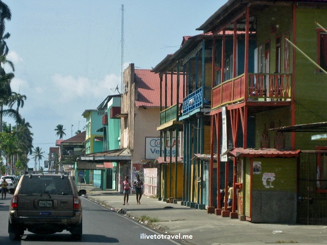
Colón, on the Caribbean end of the Panama Canal (Panama City is on the Pacific end of the Canal), is most definitely a Caribbean town.  The architecture, the people, and something in the air just made me feel I was in the Caribbean.  Interesting how less than 50 miles distance can make such a big difference!  I was told the road was really bad (the new highway is still being built but is close to being finished) but, actually, it didn’t seem that bad to me.  Perhaps I was expecting rural Tanzania type of road conditions…  Anyhow, the drive took an hour and a half and it will be very nice when this highway is finished as it should take an hour or less.   The drive is scenic though my relatives said it wasn’t totally safe.  Colón is the second largest trade free zone in the world (after Hong Kong) and it seems to be doing OK with that business.  I wish I had more time to stay around and explore but we had to get back to Panama City as I was leaving the next morning.

architecture, Colon, Panama, Caribbean, street scene, colorful, vacation, travel, photo, Canon EOS Rebel

Damaged building

architecture, Colon, Panama, Caribbean, street scene, colorful, vacation, travel, photo, Canon EOS Rebel

Typical home in the center of Colón

architecture, Colon, Panama, Caribbean, street scene, colorful, vacation, travel, photo, Canon EOS Rebel

The streets of Colón are very colorful!

An inland “oasis” in Gamboa

I also got to visit Gamboa in the interior and next to Lake Gatún (which provides the water the Panama Canal needs to operate since water is a key tool in operating the gates or “esclusas” that control ships crossing the Canal).  We visited the Gamboa Resort which had great views of the area.

Gamboa, resort, Lake Gatun, Panama, tropical, travel, photo, vacation, Canon EOS Rebel

The view from the main building at the resort: spectacular!

There are tours that take you to see monkeys and other wildlife as well as a canopy tram tour that allows a bird’s eye view over the area.  Next time, I will try to take advantage of some of those tour opportunities for a change!

Beach time near Coronado

Finally, we went to a beach next to Coronado on the Pacific called Punto Barco where one of my cousins has a beach house.  The beach may not be the best in the world but to have a house there would be a dream!  My cousin outdid herself with great food (ceviche!!) and the family had a great time hanging out.Coronado, Punto Barco, Panama, beach, Pacific coast, tropics, travel, photo, sand, Canon EOS RebelCoronado, Punto Barco, Panama, beach, Pacific coast, tropics, travel, photo, sand, Canon EOS Rebel

As usual, my visit ends and I long for more time there.  My relatives there always manage to take great care of us and make us feel very welcome.  I hope to go back and maybe this time not take 2 years in between trips!

%d bloggers like this: