Canyonlands seems endless: truly a Mighty Five National Park! Along with Arches, Zion, Bryce Canyon, and Capital Reef, it is one of the Mighty 5 U.S. National Parks in Utah.
Canyonland National Park is located near Moab, Utah and not far from Arches National Park, it is far from from a major airport but certainly worth the effort. We spent two days exploring Canyonlands which was perfect in the context of our broader trip covering the Mighty Five.
Attacking Canyonlands: Island in the Sky District
The park is made of several districts with Island in the Sky being easily the most accessible and with a lot to offer to hikers and non-hikers alike. It was easy to spend two days and leave territory not-covered, even just in Island in the Sky. This district’s main roads are in the form of a “Y”. One enters on the top right of the Y, the only entrance/exit to this district (with a main paved road).

We had dedicated two days to Canyonlands, the second of the Mighty Five U.S. National Parks we were visiting on this hiking trip. We decided to split the visit as follows:
- Day 1: The lower leg of the Y, starting by going all the way to the bottom and making our way back up (and out). On this day, we visited the following:
- Orange Cliffs Overlook facing the Green River
- Buck Canyon Overlook facing the Colorado River
- Grand View Point Overlook walking along the rim
- Murphy Trail.
- Day 2: The upper part of the Y, starting at the far end of the left upper arm of the Y. These were all short hikes, easily accessible.
- Upheaval Dome
- Whale Rock
- Aztec Butte
- Mesa Arch
- Shafer Canyon Overlook.

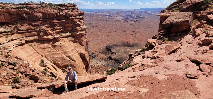
Grand View Point Overlook and a good intro to Canyonlands
After stopping at the Orange Cliffs and Buck Canyon Overlooks, we proceeded to Grand View Point Overlook. As we entered the trail, we happened upon a 10 AM outdoor park ranger talk. Very fortunate as I learned a lot about the major forces that shaped the terrain and created the multiple layers of different colors and compositions we see today.


The trail to the overlook was a short and highly rewarding 1.8 mi walk along the canyon rim with little elevation gain though you are in an altitude of ~6,000 ft. There is a short rock climb to get to the best viewpoint – and great spot for photos!


Wrapping up day 1: Murphy Trail
Murphy Trail was going to be our strenuous hike on this day. Not because of the length, as it was not too long (a 4.5-mile hike), but because we started in the afternoon and it was one very hot day. On and it would be steep with an elevation gain of 1,109 ft. The initial part of the trail was a walk on a field that did not have much to say in its favor. But then we reached the edge and began the best part of this fun hike. The terrain included rock scrambles and the like, and the view was always breathtaking once we left the field.


Once we got to the connector to the loop trail at the bottom, we stopped for lunch (at the “green” rock level) before beginning he hike back up to the rim. Though it was a very hot day, with good hydration and electrolytes, we did it safely and greatly enjoyed the hike: navigating the rocks, the descent/ascent, and the great vistas and rock formations.

Certainly, a few degrees cooler would have been nice. But the ice cold water awaiting for us in the cooler we had in the car felt like heaven as I poured it over my head and feet!
Upheaval Dome
Day 2 was not going to be the strenuous hike day, but a day full of moderate or easy relatively short hikes for us. Upheaval Dome was our first destination of the day.
There were two overlooks, the first of which was about halfway in. The trail, an in-and-out, was only only 1.3 miles but with 226 ft elevation gain. Not strenuous at all but providing a great vantage point to look at Upheaval Dome. It was unlike any sight we saw or were going to see during our time in the park. It was a circular hole, as in a volcano’s caldera or a crater, but inside there were massive, tilted rock formations of a greenish color.

Whale Rock
Right by Upheaval Dome was Whale Rock. No explanation needed for its name… It is about a 0.8-mil trail roundtrip though we tooled around a little so maybe it was a mile for us. Elevation gain is 128 ft to the top. Not strenuous but has a steep spot that some may take slow. It offers a good view of Island in the Sky with little effort. Just because a trail is short it does not mean shoes with good traction are not necessary: always good to have them because of the sloped nature of some of the rocks one will walk on on trails like Whale Rock.

Aztec Butte
The walk to Aztec Butte was not that exciting but the climb to the top of the butte offered a nice challenge with a very steep rock face.


Right below the top are small “caves” that I imagine were used by people long ago. I read that they were used to store grains and other food.

The roundtrip is about 1.4 miles with 213 ft elevation gain (all when the butte is reached). Great views from the top.

And, no, no Aztecs lived in the area…
Mesa Arch
The combination of a short hike at 0.83 miles and the amazing structure of Mesa Arch make this a definite must-see. Only 102 ft elevation gain to boot so relatively easy. It does require, though, walking on rough terrain and stones. But, through the arch ones has a great view of the canyons below and the La Sal Mountains afar.


Canyonlands is a phenomenal place for all, hikers and non-hikers alike. The beauty of the canyons is outstanding. The Colorado and Green Rivers add to the scenery as they snake their way down the canyons. But what certainly caught my eye was the variety of colors across the many layers of rock exposed for us to see!
Leave a Reply