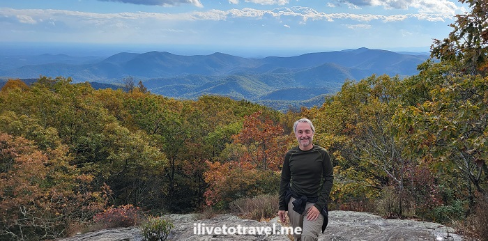
On the Appalachian Trail up to Blood Mountain

Living in Atlanta, I am blessed to be within 1.5-2.5 hrs of really phenomenal mountain hiking. While we have many nature trails within the city itself and around I-285 (our ring road), the majesty of the south Appalachians is within easy reach. And so was Blood Mountain.

This fall, I left home with a hiking buddy at 1:30PM and got started on the route around 3:30PM. We had picked starting on the Appalachian Trail’s Neels Gap as the route to climb Blood Mountain (4,458 ft in elevation). Blood Mountain is on the Appalachian Trail proper.

Blood Mountain, Appalachian trail, hiking in north Georgia, fall foliage, nature, hiking near Atlanta
The skies and the trees welcome us to north Georgia

Luckily for the avid hiker, there are several trails to go up Blood Mountain from either side: Neels Gap, Freedom Trail, Slaughter Creek. I had hiked it up via Freedom Trail a few years ago. However, we could not park at Neels Gap but a quarter of a mile away, there was another trailhead: Byron Reese Trail.

Headed up Blood Mountain via Byron Reese Trail

Byron Reese was about 0.7 mi away from connecting with the Appalachian Trail (and the entry point coming from Freedom Trail). From there up to the summit it would be about 1.6 mi each way by my estimation.

Blood Mountain, Appalachian trail, hiking in north Georgia, fall foliage, nature, hiking near Atlanta
The trailhead started with this – it bode well!

The trail up was moderate in terms of terrain with many roots, stones and rocks, and segments that were relatively smooth. The rocks often were purposefully laid steps. There were also larger masses of stone (granite perhaps?). Thankfully, though the larger masses of stone and the rocks were wet that day, they were not slippery (unless they had moss on them which not many did in October).

The white mark on the tree is specific to the Appalachian Trail
Blood Mountain, Appalachian trail, hiking in north Georgia, fall foliage, nature, hiking near Atlanta
Spectacular!
Blood Mountain, Appalachian trail, hiking in north Georgia, fall foliage, nature, hiking near Atlanta
We met a local

While the terrain was moderate to me as an experienced hiker, there was certainly enough inclines to be challenging enough for the short distance. It may be a harder trail for someone newer at hiking.

As one approaches the summit, there is an initial clearing offering a phenomenal view south to much lower mountains and hills. Clearly, Blood Mountain is higher than all visible terrain looking south.

Blood Mountain, Appalachian trail, hiking in north Georgia, fall foliage, nature, hiking near Atlanta
At the first clearing – better view that from the summit!

Atop Blood Mountain!

But, that is not the summit. The terrain is granite stone interspersed with vegetation. As one follows the trail, it becomes very narrow and surrounded by tall bushes. One wonders if one already summited. However, all of a sudden, you see the rear of the shelter available to Appalachian Trail hikers right at the summit.

Blood Mountain, Appalachian trail, hiking in north Georgia, fall foliage, nature, hiking near Atlanta, AT shelter
The shelter and my hiking buddy on Blood Mountain

Climb up the large rocks right by the shelter for more good views, though far from a 360 degree view.

Blood Mountain, Appalachian trail, hiking in north Georgia, fall foliage, nature, hiking near Atlanta
View from the summit
Blood Mountain, Appalachian trail, hiking in north Georgia, fall foliage, nature, hiking near Atlanta
At the summit’s top rock

We want down the same route we had gone up (vs. continuing on the Appalachian Trail down to Slaughter Creek. It started lightly raining on the way down and we even had small pellets of ice. It was a great wrap-up to a shorter (4.6 mi total) but awesome hike surrounded by the perfect scenery that fall provides at this time of year!

Blood Mountain, Appalachian trail, hiking in north Georgia, fall foliage, nature, hiking near Atlanta
Picture perfect colors from the summit

Checking out Cloudland Canyon State Park

On a very cold fall morning (actually, late morning as it was 11:45AM) I started what would be a super cool hike in Cloudland Canyon State Park in NW Georgia. NW as in the true corner of Georgia where it meets Alabama and Tennessee, in the Cumberland Plateau. A friend selected this state park, two hours’ drive away from Atlanta, for our Sunday hike. Excellent choice!

The state park offers several trails but the most epic one is the one that allows the hiker to properly appreciate the Cloudland Canyon: the West Rim Loop Trail. Oh, and worth noting the park offers fishing, horseback riding trails, picnicking and the like. For those not hard-core hikers, the Overlook Trail offers a way to see some of the beauty.

cloudland canyon state park, hiking, north Georgia, outdoors, nature, fitness
Approaching the trails from the parking lot

The West Rim Loop Trail

The trail actually starts with an in-and-out section that is about 1-mile+ long that crosses Daniel Creek. It is worth noting (and expressing gratitude!) that this state park is so well prepared for us hikers. It has excellent, readable signage (Iowa State University is a sponsor or supporter of these – thank you!) and very reliable trail markers (yellow for the West Rim Loop Trail).

There are some magnificent rock formations of different sorts, which are also seen further south in the trails of north Atlanta.  Certainly, one can envision how the natives in the area used those formations for their shelter.
Yellow marks the way!

Also, there are many well-prepared lookouts, many with very good and sturdy railings, and some vantage points just left open as nature set them up!

cloudland canyon state park, hiking, north Georgia, outdoors, nature, fitness
One of the many vantage points
There are some magnificent rock formations of different sorts, which are also seen further south in the trails of north Atlanta.  Certainly, one can envision how the natives in the area used those formations for their shelter.

At the end of it (35 minutes later), it meets up with the loop part of the trail, about a 2-mile hike reaching about 1,900 ft altitude. We completely guesses which way to go once we got to the loop and we opted to go left.

Good choice. Though it starts with a long uphill, the left side offered a great view over a plain-like area and a town that I believe was Trenton, Georgia. At some point, the loop hit a rocky promontory sort halfway through and then the trail turned to face to east rim and rockface of the Cloudland Canyon.

Checking out rock formations

There are some magnificent rock formations of different sorts, which are also seen further south in the trails of north Atlanta.

cloudland canyon state park, hiking, north Georgia, outdoors, nature, fitness

Certainly, one can envision how the natives in the area used those formations for their shelter.

hiking, rock formations, north Georgia, nature, outdoors, ilivetotravel
Not my home but in a bind…

The walls of a grand canyon

Wow! What a spectacular and long canyon-face! Certainly that was the part to see after passing the mid-point of the loop! One is rewarded with many lookouts (in-and-out very short trails) to enjoy the view.

cloudland canyon, georgia state park, nature, outdoors, hiking

Overall, the West Rim Loop Trail is 5 miles long. It took us 3 hours with the stops we made on the lookouts, random photos and snack/water breaks. There were other hikers but far from “crowded”.

One neat thing is that there are yurts and cabins in this trail. I think it would be awesome to do an overnight or two and see the scenery at different times of day.

Oh, and there’s more! Waterfalls!

Once we finished the trail, we went to see Cherokee Falls which is near the entrance to the trail. It is a spectacular climb down stairs (with the subsequent climb back up!) to get to it. The path that is not a staircase is much easier to handle!

cloudland canyon state park, hiking, north Georgia, outdoors, nature, fitness

One passes a MASSIVE boulder hanging over the trail (with a bench under it).

cloudland canyon state park, hiking, north Georgia, outdoors, nature, fitness
Don’t linger long under it!

The waterfall setting is well worth the trouble as were those at Panther Creek, another rewarding hike to a waterfall in north Georgia. My knees were a little sore when we finished the loop trail but, boy, did I make the right choice going down to see the waterfalls! The roundtrip to see the waterfall was a mile. Another mile roundtrip would have taken us to a downstream waterfall, Hemlock Falls. But, at 6 miles and my knees, I was glad to leave that for a future visit!

cloudland canyon state park, hiking, north Georgia, outdoors, nature, fitness
This is the reward – a spectacular spot!

If I were to return, besides trying to stay overnight at a yurt or cabin, I would certainly do it a little earlier in the fall because the color change of the trees would only add another level of spectacular to what is already a spectacular setting!

Hiking Arabia Mountain near Atlanta

Just when I think I have explored a good bit of hiking trails near Atlanta, last weekend a pleasant surprise awaited me: Arabia Mountain National Heritage Area. Right outside of Atlanta, right by the town of Lithonia is a series of trails that span a good bit, anchored by Arabia Mountain.

If you have ever heard of Stone Mountain, imagine a smaller sibling of that large single granite rock outcrop in the flatter land around and that is Arabia Mountain.

The “ascent” to the top of Arabia Mountain

Standing at 955 ft, Arabia Mountain is a little more than half the altitude of Stone Mountain. Maybe not as impressive as Stone Mountain but I was pleasantly surprised as I hiked 2 miles+ to get to its base on a cold and gray winter Saturday afternoon. The slope is gentle and relatively easy. The path up is marked with small stone towers that fit in with the landscape.

At the top, there are pools of water perhaps mainly due to recent rains and lots of moss and delicate vegetation. While it was not the best day for views, I rather prefer days with cloud coverage and a slight chill in the air for my hikes. The only bad thing about choosing that day to go up was that the view was limited and we could not see too far beyond the near vicinity of the area.

Arabia Mountain, hiking near Atlanta
At the summit
Arabia Mountain, hiking near Atlanta
At the summit

Hiking around the lake at Arabia Mountain

After descending, we decided to do a loop around the lake at the base of the mountain. It was a neat trail looking at the lake and the rock of the mountain behind it.

Arabia Mountain, hiking near Atlanta

After completing the non-mountain side of the lake, we stepped onto the mountain walking along its lower edge along the opposite side of the lake. It was not the most comfortable walk as our feet were not horizontal and it was slippery from the rain but it was sort of fun.

Hiking in Atlanta, hiking Arabia Mountain

The lake area felt pristine and the path was mostly a nature trail so that was a real treat.

Hiking in Atlanta, hiking Arabia Mountain

Our approach to get to Arabia Mountain

There is a parking lot right at the base of Arabia Mountain for those not as inclined to make a longer hike.

However, as I mentioned, this is all part of a larger network of trails that cross Dekalb and Rockdale counties from Lithonia all the way to the Monastery of the Holy Spirit.

While not our original plan, we were quite pleased at how things turned out. We ended up in one of the parking areas near the mountain but not the one at its base or the next closest one.

Instead, we parked near Vaughters farm, about 2 miles from the mountain. The trail began on a paved path (why do they insist on concreting trails…) along the fields of the Vaughters farm. It took me back to my days doing the Camino de Santiago. Rolling hills of green surrounded by forests until a mile later, when we hit the Davidson-Arabia Mountain Nature Center. Another mile took us to the Arabia Mountain trailhead which also house a wildlife center.

Vaughters Farm in near Arabia Mountain Park in Dekalb County, near Atlanta, Georgia
Set in beautiful rolling fields surrounded by woods
Trailhead to Arabia Mountain, hiking near Atlanta, Georgia
Trailhead at Vaughters farm. Windy little path…

Of course, the walk back to Vaughters farm was 2 miles but enjoying the landscape around was very rewarding even if the rolling hills were getting to me on the last mile of my 7.5 mile hike (which took 2 hours and 40 minutes)…

hiking near Arabia Mountain near Atlanta

To get to Arabia Mountain just go on I-20 East from downtown Atlanta (maybe 40 mins with good traffic?), well past I-285 to exit 74. As a reference, Arabia Mountain is southwest of Stonecrest Mall, if you are familiar with the area.

%d bloggers like this: