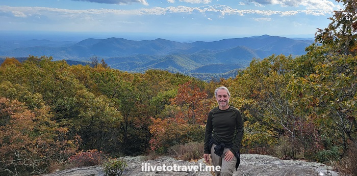
On the Appalachian Trail up to Blood Mountain

Living in Atlanta, I am blessed to be within 1.5-2.5 hrs of really phenomenal mountain hiking. While we have many nature trails within the city itself and around I-285 (our ring road), the majesty of the south Appalachians is within easy reach. And so was Blood Mountain.

This fall, I left home with a hiking buddy at 1:30PM and got started on the route around 3:30PM. We had picked starting on the Appalachian Trail’s Neels Gap as the route to climb Blood Mountain (4,458 ft in elevation). Blood Mountain is on the Appalachian Trail proper.

Blood Mountain, Appalachian trail, hiking in north Georgia, fall foliage, nature, hiking near Atlanta
The skies and the trees welcome us to north Georgia

Luckily for the avid hiker, there are several trails to go up Blood Mountain from either side: Neels Gap, Freedom Trail, Slaughter Creek. I had hiked it up via Freedom Trail a few years ago. However, we could not park at Neels Gap but a quarter of a mile away, there was another trailhead: Byron Reese Trail.

Headed up Blood Mountain via Byron Reese Trail

Byron Reese was about 0.7 mi away from connecting with the Appalachian Trail (and the entry point coming from Freedom Trail). From there up to the summit it would be about 1.6 mi each way by my estimation.

Blood Mountain, Appalachian trail, hiking in north Georgia, fall foliage, nature, hiking near Atlanta
The trailhead started with this – it bode well!

The trail up was moderate in terms of terrain with many roots, stones and rocks, and segments that were relatively smooth. The rocks often were purposefully laid steps. There were also larger masses of stone (granite perhaps?). Thankfully, though the larger masses of stone and the rocks were wet that day, they were not slippery (unless they had moss on them which not many did in October).

The white mark on the tree is specific to the Appalachian Trail
Blood Mountain, Appalachian trail, hiking in north Georgia, fall foliage, nature, hiking near Atlanta
Spectacular!
Blood Mountain, Appalachian trail, hiking in north Georgia, fall foliage, nature, hiking near Atlanta
We met a local

While the terrain was moderate to me as an experienced hiker, there was certainly enough inclines to be challenging enough for the short distance. It may be a harder trail for someone newer at hiking.

As one approaches the summit, there is an initial clearing offering a phenomenal view south to much lower mountains and hills. Clearly, Blood Mountain is higher than all visible terrain looking south.

Blood Mountain, Appalachian trail, hiking in north Georgia, fall foliage, nature, hiking near Atlanta
At the first clearing – better view that from the summit!

Atop Blood Mountain!

But, that is not the summit. The terrain is granite stone interspersed with vegetation. As one follows the trail, it becomes very narrow and surrounded by tall bushes. One wonders if one already summited. However, all of a sudden, you see the rear of the shelter available to Appalachian Trail hikers right at the summit.

Blood Mountain, Appalachian trail, hiking in north Georgia, fall foliage, nature, hiking near Atlanta, AT shelter
The shelter and my hiking buddy on Blood Mountain

Climb up the large rocks right by the shelter for more good views, though far from a 360 degree view.

Blood Mountain, Appalachian trail, hiking in north Georgia, fall foliage, nature, hiking near Atlanta
View from the summit
Blood Mountain, Appalachian trail, hiking in north Georgia, fall foliage, nature, hiking near Atlanta
At the summit’s top rock

We want down the same route we had gone up (vs. continuing on the Appalachian Trail down to Slaughter Creek. It started lightly raining on the way down and we even had small pellets of ice. It was a great wrap-up to a shorter (4.6 mi total) but awesome hike surrounded by the perfect scenery that fall provides at this time of year!

Blood Mountain, Appalachian trail, hiking in north Georgia, fall foliage, nature, hiking near Atlanta
Picture perfect colors from the summit

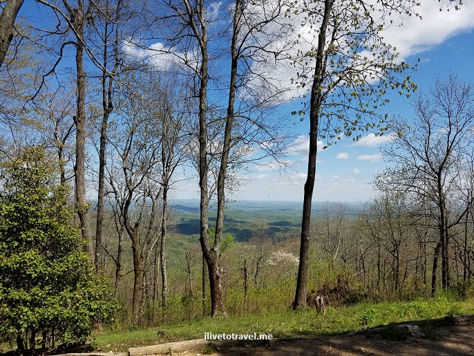
Hike to an Inn in North Georgia

If you are a casual reader of this blog, you will know that I enjoy hiking near and far from my home.  One of the “near” hikes on my list to check out was the hike to the Hike Inn in north Georgia.  The Hike Inn can only be accessed by hiking to it hence the name (actually, it’s full name is Len Foote Hike Inn).  There is a service road leading to it but, as the name implies, it is for service, not for guests.  Guests need to do the 5 hour hike in and out.

The trail begins atop Amicalola Falls (about 1.5 hrs/70-mile drive from Atlanta) – a destination to check out onto itself with other trails and a phenomenally tall set of staircases if you want to walk from the bottom of the falls to the top.  On this day, we drove to the top of the falls where we would leave our vehicles.

Amicalola, falls, Hike Inn, Georgia, Atlanta, hike inn, hiking, outddors, nature, photos

The top of Amicalola Falls – awesome place!

Amicalola, falls, Hike Inn, Georgia, Atlanta, hike inn, hiking, outddors, nature, photo, trailhead

The start of the Hike Inn trail

The Hike Inn is in high demand so you need to book it in advance.  It is well worth it.  The hike is not super strenuous and you are rewarded by a magnificent place to stay.

Georgia, Atlanta, hike inn, hiking, outddors, nature, photos

Amazing detail of nature

Georgia, Atlanta, hike inn, hiking, outddors, nature, photo

Along the trail

Georgia, Atlanta, hike inn, hiking, outddors, nature, photo

Our arrival at the Hike Inn!

Georgia, Atlanta, hike inn, hiking, outddors, nature, photo, sky

The view from the Hike Inn – magnificent

The accommodations are basic (bunk beds) and you can get private rooms.  The bathrooms and showers are shared but they are actually quite clean and nice (especially when compared with how basic the rooms are).  The toilets actually do not flush but, instead, deposit the waste (nice wording, huh?) somewhere below where it is taken advantage of through processes that they staff will happily explain if you decide to take them up on the tour of the facility (it is actually worth doing).

Georgia, Atlanta, hike inn, hiking, outddors, nature, photo

Hallway by the rooms

Georgia, Atlanta, hike inn, hiking, outddors, nature, photo

Bath house building

Georgia, Atlanta, hike inn, hiking, outddors, nature, photo, toilet

There are rules for the toilet

Actually, everything about the place is about taking care of the environment.  The inn offers dining service with support of volunteers who get to stay for free for their service.  The Hike Inn politely stresses the importance of not wasting food (only serve yourself what you need) and actually tracks clean plates’ count at the end of a meal.  The food is delicious and the dining area is an open space where you can meet other hikers.  Really neat.

Georgia, Atlanta, hike inn, hiking, outddors, nature, photo, lodge

Dining area

Georgia, Atlanta, hike inn, hiking, outddors, nature, photo, menu

Menu of the day

Georgia, Atlanta, hike inn, hiking, outddors, nature, photo

Chart showing how well diners have done

After dinner (or before), you can sit and relax in any number of places around the inn.  One of my favorites is the upper porch looking east-ish – I love me a good rocking chair with a view!  You can also go for short walks around.  Right in that upper porch area is a game room where people can congregate and play games or read a book.

Georgia, Atlanta, hike inn, hiking, outddors, nature, photo, lodge

The living/game room

The best part of it all is sunrise.  If you wake up early enough (and I recommend it!), go down to the sitting area below and face east.  Bring a blanket.  And then enjoy a majestic sunrise if the weather cooperates.  It is the perfect way to end the stay before starting back on the trail down.  Next time I go, I think I may stay two nights to really enjoy the place and its surroundings!  I leave you with a series of photos from the amazing sunrise I witnessed!

Georgia, Atlanta, hike inn, hiking, outddors, nature, photo, sunrise, sunGeorgia, Atlanta, hike inn, hiking, outddors, nature, photo, sunrise, sunGeorgia, Atlanta, hike inn, hiking, outddors, nature, photo, sunrise, sunGeorgia, Atlanta, hike inn, hiking, outddors, nature, photo, sunrise, sunGeorgia, Atlanta, hike inn, hiking, outddors, nature, photo, sunrise, sun
Save

Chattahoochee River Hikes: Vickery Creek Trail in Roswell

Right by old town Roswell, a few miles outside of Atlanta‘s “perimeter” (an interstate highway that rings the city), is the Vickery Creek Trail.  There are about 7 miles worth of trails in this pocket of nature in the middle of Roswell.  A portion of the trails are near the creek (also named Big Creek) which hits the Chattahoochee River right by the entrance to the parking lot I used to hit the trailhead.  This area is also part of the Chattahoochee River National Recreation Area, a collection of parks along the river which crosses Atlanta from the NE to the SW (sort of!).Vickery Creek, Roswell, Georgia, Chattahoochee, river, park, Atlanta, hiking, outdoors, nature, trail, Samsung Galaxy S7, photoVickery Creek, Roswell, Georgia, Chattahoochee, river, park, Atlanta, hiking, outdoors, nature, trail, Samsung Galaxy S7, photo

The trail offers moderate hiking, with some fairly flat portions and a few climbs that I would guess are not too strenuous to the average person.  The trails are well marked (the blue square spray painted on trees) and well signed so one can make one’s way around pretty easily.  Because of the time of the year, what seemed to me to be mountain azaleas were in bloom (pinkish flowers). Vickery Creek, Roswell, Georgia, Chattahoochee, river, park, Atlanta, hiking, outdoors, nature, trail, Samsung Galaxy S7, photo Vickery Creek, Roswell, Georgia, Chattahoochee, river, park, Atlanta, hiking, outdoors, nature, trail, Samsung Galaxy S7, photoVickery Creek, Roswell, Georgia, Chattahoochee, river, park, Atlanta, hiking, outdoors, nature, trail, Samsung Galaxy S7, photoVickery Creek, Roswell, Georgia, Chattahoochee, river, park, Atlanta, hiking, outdoors, nature, trail, Samsung Galaxy S7, photoVickery Creek, Roswell, Georgia, Chattahoochee, river, park, Atlanta, hiking, outdoors, nature, trail, Samsung Galaxy S7, photoflowers, Vickery Creek, Roswell, Georgia, Chattahoochee, river, park, Atlanta, hiking, outdoors, nature, trail, Samsung Galaxy S7, photo
What is cool about this trail is seeing the two waterfalls created by a small and a large dam.  The area around the larger waterfall is not large and one has to watch one’s step but it is a pretty spot.Vickery Creek, Roswell, Georgia, Chattahoochee, river, park, Atlanta, hiking, outdoors, nature, trail, Samsung Galaxy S7, photo, waterfall Vickery Creek, Roswell, Georgia, Chattahoochee, river, park, Atlanta, hiking, outdoors, nature, trail, Samsung Galaxy S7, photo, waterfall Vickery Creek, Roswell, Georgia, Chattahoochee, river, park, Atlanta, hiking, outdoors, nature, trail, Samsung Galaxy S7, photo, waterfall Vickery Creek, Roswell, Georgia, Chattahoochee, river, park, Atlanta, hiking, outdoors, nature, trail, Samsung Galaxy S7, photo, waterfall

There are also a covered bridge and a large span bridge further down which facilitate cross the creek to other trailheads and parking areas.   Whether you are here in Atlanta to go up to the mountains or just visiting the city, this trail is one of many easy to visit and yet offering a unique hiking experience!

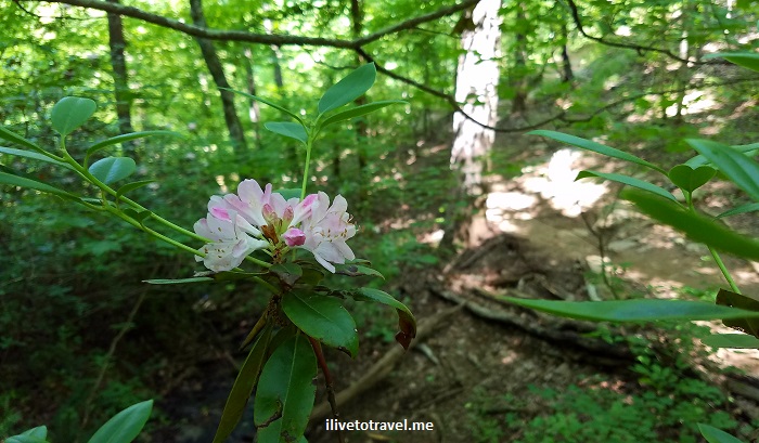
Panther Creek: A Challenging and Rewarding Hike in North Georgia

I was looking for a hike that I could do within 4 hours that was not right on the outskirts of Atlanta.  A friend and I were looking for a more challenging hike than the usual so after selecting a few finalists, we settled on Panther Creek, about an hour and a half north of Atlanta.  We decided to hike 3.5 hrs in to the larger waterfalls and then back.  The entrance to the trail on Panther Creek is on Old Historic 441 in north Georgia, northwest of the town of Ellijay.

Soon after entering the trail, you go under the new 441. After that, you leave hearing highway noise and slowly, but surely, start hearing water running sounds…  The trail is more natural (read, not groomed) and that makes it quite a neat trail to hike.

Panther Creek, trail, hiking, Georgia, cascade, waterfall, nature, outdoors, photo, Olympus

Towards the start of the Panther Creek trail – love the woods

Panther Creek, trail, hiking, Georgia, cascade, waterfall, nature, outdoors, photo, Samsung Galaxy

Lots of rock outcrops where one can imagine people ages ago taking shelter under them

You go down a narrow path and slowly go downhill. Eventually you are closer to creek level and closer to the creek itself.

Panther Creek, trail, hiking, Georgia, cascade, waterfall, nature, outdoors, photo, Olympus

Beautiful colors at the time of the year I visited

Panther Creek, trail, hiking, Georgia, cascade, waterfall, nature, outdoors, photo, Samsung Galaxy

Panther Creek, trail, hiking, Georgia, cascade, waterfall, nature, outdoors, photo, Olympus

More beauty

Panther Creek, trail, hiking, Georgia, cascade, waterfall, nature, outdoors, photo, Olympus

Still waters

There are several low wooden bridges to cross and then one arrives to a first set of cascades with a space that is perfect for camping overnight.

Panther Creek, trail, hiking, Georgia, cascade, waterfall, nature, outdoors, photo, Samsung Galaxy

One of the bridges crossing the creek

Panther Creek, trail, hiking, Georgia, cascade, waterfall, nature, outdoors, photo, Samsung Galaxy

Love these cascades

A couple of times the markers for the path were not visible and we proceeded trusting that the wild we saw in front of us was just an overgrown trail (and, mercifully, we were right!).

Continuing on from that spot, another 30-45 minutes or so depending on pace, one arrives at the upper waterfalls with a sort-of sandy beach to camp overnight or just recover from the hike in. Right before arriving at this waterfall, the terrain becomes a little more challenging and fun. One has to hug the big rocks holding on to the steel-cable handrails. These handrails are anchored on posts, some of which are sturdy and some of which have come loose and are floating, being kept alive by the two neighboring posts! One does need to proceed with care as falling from this rock outcrop would not be fun.

Panther Creek, trail, hiking, Georgia, cascade, waterfall, nature, outdoors, photo, Samsung Galaxy

The steel cable handrail itself is precarious!

Panther Creek was both rewarding and challenging. The raw feel of the trails was a welcome change from some of the other trails I hike in north Atlanta (which are quite nice but well groomed). I highly recommend doing this trail – I sure hope to do it again!

Panther Creek, trail, hiking, Georgia, cascade, waterfall, nature, outdoors, photo, Samsung Galaxy

A nice break after 3.5 miles!

—————————————————————————————————————

Read about these other great hikes in Georgia:

Sope Creek

Sweetwater Creek

Island Ford

Tallulah Gorge

… and more to come!

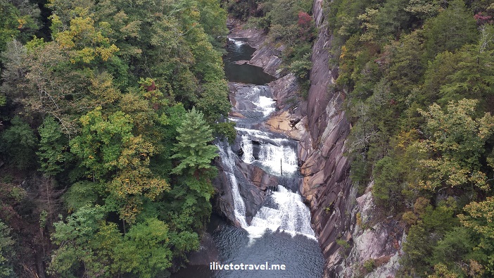
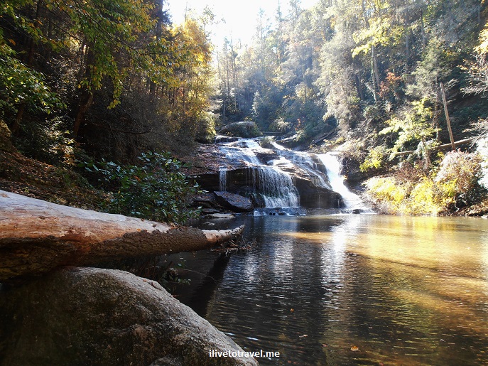
A Hike in Tallulah Gorge State Park

Tallulah Gorge State Park is located pretty much in the northeast corner of the state of Georgia.  The park centers around the Tallulah Gorge around the – guess what- Tallulah River.  The river starts in North Carolina and eventually makes its way to the Savannah River and the Atlantic Ocean.  It has a series of waterfalls which are collectively called -wait for it- Tallulah Falls!  It is supposed to be the most scenic canyon on the eastern seaboard of the U.S. with a depth of about 1,000 ft.  A hike in Tallulah Gorge is a must while in the area!Tallulah Falls, Tallulah Gorge, Georgia, canyon, hiking, north rim, south rim, photo, outdoors, nature, Samsung Galaxy 4

I visited the canyon around mid-October.  It was an unusually warm October so the leaves had not begun to change yet for real.  Driving to the park from Atlanta takes about 1.5 hrs, slightly less if you live or are staying at in the northern suburbs of the metro Atlanta.

The park has an Interpretive Center with information and exhibits for the young and the not-so-young.  These cover the history of the former resort town, local wildlife, and other topics.  The staff at the center is quite helpful and knowledgeable about the park and its vicinity.

Going for an easy hike in Tallulah Gorge

For the non-hiker or those who are interested in seeing some of the waterfalls but not climb steep staircases, the park has natural paths along the north and south rims of the gorge that are pretty easy to walk through.  These paths offer various vantage points, or overlooks, from which to soak in the view.  Walking along the north rim you can see the tower that held the tightrope Karl Wallenda used when he crossed the gorge in 1970!

Tallulah Falls, Tallulah Gorge, Georgia, canyon, hiking, north rim, south rim, photo, outdoors, nature, Samsung Galaxy 4

The view from the north rim near the Interpretive Center

Tallulah Falls, Tallulah Gorge, Georgia, canyon, hiking, north rim, south rim, photo, outdoors, nature, Samsung Galaxy 4

Checking out the gorge from one of the overlooks on the north rim

The north/south rim hike is about 3 miles long round-trip.  Depending on the pace, the hike along the Tallulah Gorge should be doable in a couple of hours.  From the first overlook, closest to the start of the trail at the Interpretive Center, there is a great view of the L’Eau d’Or (Ladore) waterfalls where yours truly had his pic taken!

Tallulah Falls, Tallulah Gorge, Georgia, canyon, hiking, north rim, south rim, photo, outdoors, nature, Samsung Galaxy 4

Looking down at L’Eau d’Or waterfalls from the overlook

Going for a deeper hike down the gorge

For those wanting to get closer to the waterfalls, the river and the bottom of the gorge… there are stairs!!  Over 1,000 steps!

Tallulah Falls, Tallulah Gorge, Georgia, canyon, hiking, north rim, south rim, photo, outdoors, nature, Samsung Galaxy 4, stairs

Let the stairs begin!

From the first overlook where my picture was taken, you can proceed to the Devil’s Pulpit where you get a great face on view of L’Eau d’Or.

L'Eau d'Or, Tallulah Falls, Tallulah Gorge, Georgia, canyon, hiking, north rim, south rim, photo, outdoors, nature, Samsung Galaxy 4

L’Eau d’Or

From this point the large staircase takes the hiker to the suspension bridge that connects the south and north rims of the gorge.

bridge, Tallulah Falls, Tallulah Gorge, Georgia, canyon, hiking, north rim, south rim, photo, outdoors, nature, Samsung Galaxy 4

Crossing the bridge

Once on the south rim, one can access the bottom of the gorge.  On some days, it is possible to go further at the bottom of the gorge but only the first 100 people get the needed pass.  However, because of the water release schedule for the upriver dam, the bottom of the gorge is not always open.  It was not when I went.  That was unfortunate because I would have loved to jump into the pool!!

pool, bottom of the gorge, Tallulah Falls, Tallulah Gorge, Georgia, canyon, hiking, north rim, south rim, photo, outdoors, nature, Samsung Galaxy 4

Pool at the bottom of the gorge

Once you reach the bottom, you can take a look at Hurricane Falls and dream of sliding down those rocks!

Hurricane Falls, Tallulah Falls, Tallulah Gorge, Georgia, canyon, hiking, north rim, south rim, photo, outdoors, nature, Samsung Galaxy 4

Hurricane Falls from the bottom of the Gorge

Tallulah Gorge, waterfalls, falls, Georgia, nature, outdoor

Signs a-plenty – “rattlesnake” weed doesn’t sound good, does it??

hikers, Tallulah Falls, Tallulah Gorge, Georgia, canyon, hiking, north rim, south rim, photo, outdoors, nature, Samsung Galaxy 4

The view you are rewarded with from the rim!

A hike in Tallulah Gorge is very enjoyable and quite doable as day trip from Atlanta or from places in Tennesse and North Carolina.  Do not miss this chance to see an amazing setting, whether for an arduous hike or a stroll!

Read about these other great hikes in Georgia:

Sope Creek

Sweetwater Creek

Island Ford

… and more to come!

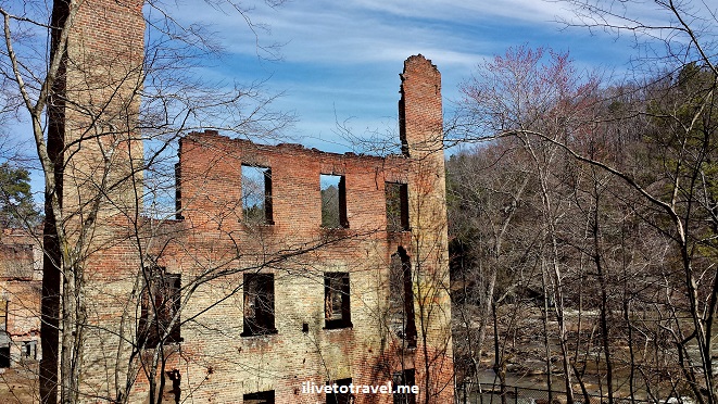
A Great Hike Right Near Atlanta: Sweetwater Creek State Park

Atlanta may not be what comes to mind when thinking for a place to go to enjoy the great outdoors. But our little known secret is how close we are to any number of incredible spots to be “with” nature and enjoy the great outdoors. I recently got to explore Sweetwater Creek State Park, a short 15 minute ride west of Atlanta, and was impressed at the place and shocked that I have been a resident of this city for close to three decades and I had never been.Sweetwater Creek State Park, mill, hiking, nature, outdoors, Atlanta, Georgia

The park sits along a reservoir (with all sorts of water activities possible, like fishing and paddle boats) and a creek flowing from it into the larger Chattahoochee River, as it makes its way down to Alabama, Florida, and eventually, the Gulf of Mexico.Sweetwater Creek State Park, mill, hiking, nature, outdoors, Atlanta, GeorgiaSweetwater Creek State Park, mill, hiking, nature, outdoors, Atlanta, GeorgiaSweetwater Creek State Park, mill, hiking, nature, outdoors, Atlanta, Georgia

A lot of work is being done around the park and its visitor center looks to be quite new.  It has some exhibits, a gift shop, and very helpful folks to answer any questions.  We got a map and were told to be sure to do the red trail as it has the more scenic views of the creek and the old mill.  Yes, as any self-respecting creek in the South must, Sweetwater Creek was the former home of a mill for the New Manchester Manufacturing CompanyNew Manchester Manufacturing Company, Sweetwater Creek State Park, mill, hiking, nature, outdoors, Atlanta, Georgia

The ruins of the mill, burnt down during the Civil War are still standing which makes for some great photo opportunities.  The fact that its ruins are still there helps transport one to the times not long ago (maybe a century ago?) when mills and ferries were commonplace in this area.  So much so that many streets in Atlanta bear names like Howell Mill, Paces Ferry, Sewell Mill, Montgomery Ferry, etc.New Manchester Manufacturing Company, Sweetwater Creek State Park, mill, hiking, nature, outdoors, Atlanta, Georgia New Manchester Manufacturing Company, Sweetwater Creek State Park, mill, hiking, nature, outdoors, Atlanta, Georgia New Manchester Manufacturing Company, Sweetwater Creek State Park, mill, hiking, nature, outdoors, Atlanta, Georgia

After doing the shorter red trail, we connected to the longer white trail.  At some point the white trail departs the shores of the Sweetwater Creek and head inland and uphill.  The whole circuit was around 5 miles and it took us about an hour and forty minutes.  It was a glorious morning in late winter in Atlanta and my first visit to Sweetwater Creek State Park could not have been any better!  And some folks planned ahead exactly how they were going to enjoy the weather and the view!Sweetwater Creek State Park, mill, hiking, nature, outdoors, Atlanta, Georgia, hammocks


————————————————————————————————

Read about these other great hikes in Georgia:

Sope Creek

Panther Creek

Island Ford

Tallulah Gorge

… and more to come!

%d bloggers like this: