How to Explore Crater Lake National Park

Oregon is known for many great landscapes from its magnificent coast to the Cascade Mountains, to the Willamette Valley, to the Columbia River Gorge, etc. But one of its most spectacular sights has to be Crater Lake.

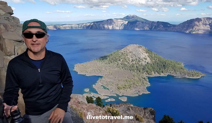
Crater Lake, since 1902 part of Crater Lake National Park, serves as witness to the incredible story of earth’s forces at work. Mount Mazama, the original volcano on that site, blew up about 7,700 years ago. The top of the volcano collapsed inward after all the contents spewed out (non-technical terms!) and created a caldera that has filled up with water since then from rain and snow melt.

Crater Lake, Mount Scott, hiking Crater Lake, Oregon, outdoors, nature. exploring Oregon
View towards the west from Mt. Scott

The lake is between 4.5-6 miles across and about 1,943 ft deep. It is considered the deepest lake in North America. And another bit of trivia: it holds almost 5 TRILLION gallons of water. Lots of H2O.

Though no streams flow out of this lake, the water level remains fairly constant because water does seep out or gets absorbed. The water has very little in terms of sediment flowing in (again, no streams feeding it) which helps give it its unique color. It is an intense, beautiful, entrancing blue.

Do the Crater Lake rim drive!

Today, one can drive all around the rim of the lake, a 33-mile drive, dotted with stopping points offerings great views all around the volcano’s caldera. Well, one can as long as it is between mid-October and June as the road closes the rest of the year due to snow… There are two entrances to the park, one approaching the park from the south via route 62, and another from the north.

Crater Lake National Park map, Oregon, national park service, hiking in Crater Lake, overlooks in Crater Lake
In red ovals, some of the places mentioned

We came in through the southern entrance which is where Park Headquarters and the Visitor Center are located. This southern shore of the lake hosts the Rim Village with an overlook, café, and Crater Lake Lodge (which was closed during my visit thanks to Covid).

Let me share with you the places I explored in my visit along this great drive and let you decide which offered the best views of this incredible lake. Hopefully these suggestions will help you plan your own visit!

Phantom Ship Overlook

We did the rim drive counterclockwise. Starting from the southern entrance in this direction, the first part of the drive is a long of windy road with no views of the lake for the most part but still a beautiful ride. Sometimes the curves do not have guardrails so mind your driving!

But soon, than changes and the rest of the rim drive is mostly just going around the edge of the crater. That means lots of great places to stop to admire the beauty of the lake and see it from another angle.

The first stop we made was at the Phantom Ship Overlook. There are a couple of stops you can make before this one (Sun Notch which offers a nice direct view down to Phantom Ship, and Dutton Cliff) but we decided to make Phantom Ship Overlook our first stop. Phantom Ship is a tiny island on the southern side of the lake – quite photogenic, especially with the trees on the edge of the lookout framing the view nicely.

Phantom Ship, island in Crater Lake, hiking in Oregon, Crater Lake National Park

After the Phantom Ship Overlook come a couple of small stops: Pumice Castle and Cloudcap Overlook (which looks straight due west onto Wizard Island in the opposite side of the lake). Nice, brief stops and – as usual – with views that do not disappoint.

Mt. Scott: The highest point at Crater Lake

There are a few mountains or peaks rising out of the area around the rim at Crater Lake. Mount Scott offers the tallest point around Crater Lake, and is a great hike taking you to 8,929 ft. The hike is about 4.5 miles round-trip.

Crater Lake hikes, hiking Mount Scott, Crater Lake park in Oregon, trails in Crater Lake
Mount Scott, tallest point in Crater Lake, hiking in Crater Lake
Cleetwood Cove, Mt. Scott hike,  Crater Lake, Oregon, hiking in Crater Lake, outdoors, cold water swim
Nice zig-zags!

Though steep (the elevation gain is 1,200 ft), it is a beautiful path and doable without gear (though I always carry my hiking pole to ensure my knee is not pounded too much!).

Crater Lake hikes, hiking Mount Scott, Crater Lake park in Oregon, trails in Crater Lake
Nice day with clear views!

It is a neat hike and one gets rewarded with a nice short walk at the top with many spots for photo opps while making one’s way to the peak itself.

Crater Lake hikes, hiking Mount Scott, Crater Lake park in Oregon
I think the lake is that way. Or the other… No Columbus here!

And the peak area is not a bad place to eat your lunch while soaking in the views!

Crater Lake hikes, hiking Mount Scott, Crater Lake park in Oregon, trails in Crater Lake
Taking a break for the view!
Crater Lake hikes, hiking Mount Scott, Crater Lake park in Oregon, trails in Crater Lake
Brought my family with me, as usual 🙂

Skell Head Overlook

After getting off Mt. Scott, a good stop to follow is the Skell Head Overlook.

Skell Head overlook, Grotto Cove, Crater Lake, Oregon, hiking
Grotto Cove on the right and towards Cleetwood Cove (not visible here)

Plenty of parking and space to – once again – soak the views of the lake and have some photos snapped (always better than a selfie!).

Skell Head overlook, Grotto Cove, Crater Lake, Oregon, hiking

Cleetwood Cove Trail – swim in the lake!

For those wanting to jump in the water, there is only one spot where it is legal to jump into the lake. And it requires a steep 1.1-mile down hike (with the corresponding 1.1-mile steep hike back up…) so it may not be for everyone. If it is up for you, know that the elevation difference is 700 ft. This is what the hike looks like:

Cleetwood Cove, swimming in Crater Lake, Oregon, hiking in Crater Lake, outdoors, cold water swim, hike map
The vertical line at the top is walking across the parking lot!

It is worth noting this is one of the best parking areas on this northern and eastern parts of the rim. Two structures at either end of the large parking lot offer restroom facilities though be ready for the basic type of restrooms… Plenty of parking for a busy August day so that certainly was well-thought out for this most popular stop on Crater Lake’s rim road.

Cleetwood Cove, swimming in Crater Lake, Oregon, hiking in Crater Lake, outdoors, cold water swim
The trail is mostly shaded but not always

Once down there, there is no sand beach. Just lots of rocks to climb over and then to walk on to get into the full water. There is one spot down there from where it is allowed to jump into the water and save the rock walking (well, you have to do those to get out of the water). I suggest wearing water shoes as the rocks under water can be slippery but you may feel safer with your naked feet.

Cleetwood Cove, swimming in Crater Lake, Oregon, hiking in Crater Lake, outdoors, cold water swim
Beautiful water colors – and lots of rocks
Cleetwood Cove, swimming in Crater Lake, Oregon, hiking in Crater Lake, outdoors, cold water swim
The beautiful water lies… it’s coooold!

In mid-August the water just completely freezing so not sure how it feels at the beginning or the end of the season, though I imagine it likely does not change much… I waited for my buddy to try the water before I went in. I sloooowly made my way in…

Cleetwood Cove, swimming in Crater Lake, Oregon, hiking in Crater Lake, outdoors, cold water swim

I went in but there was a strong current right by the rocks so I stayed in the water on the rocks. “Stayed” is a generous term equivalent to no more than 10 seconds. But I got my hair wet! Then, I laid back on those warm rocks to cool and dry off. Very nice!

Cleetwood Cove, swimming in Crater Lake, Oregon, hiking in Crater Lake, outdoors, cold water swim
“Raul on the rocks”

Of course, the hike up was work but I didn’t carry much with me save water and a couple of other things in the small backpack.

Cleetwood Cove, swimming in Crater Lake, Oregon, hiking in Crater Lake, outdoors, cold water swim
Just. Don’t. Look. Up. While. Going. Up.

Merriam Point

Merriam Point is a small stop as the rim drive continues. It is also the point at which the northern entrance to Crater Lake National Park hits the rim road. It is a good point to look southward toward Wizard Island, which will be much closer on the next stop on the route…

Crater Lake, National Park, Wizard Island, panoramic view, hiking, Oregon hiking, great outdoors
Awesome panorama view of the lake and Wizard Is.
Crater Lake, National Park, Wizard Island, panoramic view, hiking, Oregon hiking, great outdoors
A very short walk to the viewpoint

Watchman Overlook and Watchman Peak

A short drive south of Merriam Point is Watchman Overlook. Watchman Overlook is almost at the westernmost point of the lake and was our final stop that day on the Crater Lake rim drive.

Crater Lake, Oregon, National Park Service, deepwater lake, deepest lake, Watchman Peak, Watchman Overlook, rock formation at Crater Lake
View looking left from Watchman Overlook

Watchman Overlook offers a great vantage point to see the lake and Wizard Island. And, for those inclined to tackle a good incline, it also offers a hiking trail up to Watchman Peak.

Crater Lake, Oregon, National Park Service, deepwater lake, deepest lake, Watchman Peak
Watchman Peak and the trail as seen from Watchman Overlook

It is a 0.8-mile walk up a steep path but the view is a very nice reward.

Crater Lake, Oregon, National Park Service, deepwater lake, deepest lake, Watchman Peak trail
The trail
Crater Lake, Oregon, National Park Service, deepwater lake, deepest lake, Watchman Peak, hiking Crater Lake
Excellent view of Wizard Island from the peak

After Watchman Overlook, had we had more time that day, we would have gone towards the lodge where a trail goes to the top of Garfield Peak which, at 8,054 ft, is just slightly taller than Watchman Peak. Garfield Peak is on the south edge of the lake so it would have offered a totally different vantage point so you may want to check it out. Of course, you don’t have to climb the peak to see the views north as the Rim Village would offer a similar view but just from rim level.

If you have not gathered yet, I thoroughly enjoyed Crater Lake National Park and all the views and activities that if offers. I have not visited many of our national parks but they are certainly a great treasure and I hope to be planning visits more often than I have before!

Crater Lake, Oregon, National Park Service, deepwater lake, deepest lake, cobalt blue water
Goodbye, Crater Lake

11 Places to See on the Oregon Coast

The Oregon coast stretches for over 360 miles (580 km) facing the mighty Pacific Ocean. To drive along the coast non-stop would take approximately seven hours on U.S. Route 101. Of course, stops are likely and recommended to plan well! We did the top third on one day, and the remaining on a second day.

Oregon coast, Pacific coast, beaches, Cape Sebastian, rock formations, great drive

Background on Oregon’s coast

The Oregon coast, as much of the Pacific coast of the United States, was first explored by the Spanish. Soon, thereafter the British (like Cook or Vancouver) also explored the Pacific Northwest coast. Most notably, the Lewis and Clark expedition got to the northwest corner of Oregon near Astoria.

The entire coast of Oregon is public land. Some technical terms define exactly how far from the water but the point is that all waterfront is public land and available for public use (while allowing for easements for coast-facing property owners).

This means that one can uninterruptedly explore the coast with its many features: beaches, rocky terrain, lighthouses, capes, historical sites, etc. There is a great variety of features dotting the coast allowing for a good number of activities for every taste (beach, hiking, small-town exploring, kite flying, water sports, fishing, and on and on).

There are different characteristics of the coast.

  • The northern segment is more likely to have longer, uninterrupted beaches. Cannon Beach and Tillamook would fall under this northern segment.
  • As you move further south, more small cliffs and terraces appear. Small neat towns like Yachats are part of this central coast adding more charm.
  • The southern part is more hilly so the cliffs and capes are taller. There are also beaches but they did not seem as vast as the northern ones. And sand dunes make their appearance in this section. Bandon and Coos Bay are some of the towns in this area.

Rocky outcrops dote the entire coastline, making it reminiscent of the Great Ocean Road in Australia near Melbourne. Sunset along the coast, needless to say, offers spectacular scenes and great photo opportunities.

What to see along Oregon’s coast

Here are some key spots to not miss among the many available. The list is presented in a north-to-south order, not in an order of preference!

#1 Cannon Beach

As expanded upon in a separate post in this blog, Cannon Beach is a must-see. It is expansive and easy to access from the town (steps away, literally!). Check out the blog post for a suggestion of what to do intown other than the beach that everyone checks out!

#2 Tillamook

Tillamook is a town near the coast. While it is on the water, it is actually a bay. It is a town of about 5,000 sporting an air museum and the Tillamook Creamery which can be visited. We did not make these stops as we had landed on the west coast around noon and had spent time in Cannon Beach and still had a long drive to get to the Willamette Valley for the evening.

#3 Munson Creek Falls

Right after passing Tillamook, for those wanting a little non-beach activity and beautiful nature, the Munson Creek Falls are easily accessible from U.S. Route 101 and a quarter mile short walk to get to them. The dense greenery makes a lot of sense given the high level of moisture of a coastal region. The trail to the waterfall starts at a small parking lot but the final bit of the trail happened to be close so we were not able to get up close-and-personal with the waterfall. Still, a nice break with lots of fresh air for our first travel day.

Oregon, Oregon coast, Pacific coast, beaches, great drive, hiking in Oregon, rock formations

#4 Boiler Bay State Scenic Viewpoint

There are many places to pull off the road or official viewpoints. The Boiler Bay stop, just north of Devil’s Punch Bowl, is one of the nicest in terms of the views it offers up the coast, but also because it is expansive, has tons of parking, and has restroom facilities. A nice place to stop and have lunch, stretch the legs, or shoot some good photos.

Oregon, Oregon coast, Pacific coast, beaches, great drive, cliffs, rock formations

#5 Devil’s Punch Bowl at Otter Rock

This amazing rock feature is easily reached but on a busy weekend day, good luck finding parking! The parking not only serves visitors who want to see the bowl but also those wanting to visit the local shops or head down to the amazing beach. Still it is worth the trouble. You can admire the bowl and follow a short trail that sort of is an overlook onto the beach right south of it. At the right time of the year (March/April, I understand), whale-watching may also be possible from there.

Oregon, Oregon coast, Pacific coast, beaches, great drive, cliffs, rock formations, Devil Punch Bowl

#6 Yaquina Head Lighthouse

Continuing on south, the Yaquina Head Lighthouse (the tallest on the coast) is a great spot to stop and explore. When we went, we were not able to drive up to the parking area by the lighthouse itself but had to park up the road and undertake a walk that was not unpleasant.

Oregon, Oregon coast, Pacific coast, lighthouse, great drive, cliffs, rock formations

By the lighthouse you can walk to decks along the cliff to get closer to the water. Access to the ‘beach’ was closed, not sure why (Covid gives a great cover to change a few things…). But we were close enough at the lowest deck while also getting a better look at the birds nesting on the rocks. I also recommend reading the signs explaining a few topics, especially how looking at the cliff-side and the rocks shows you how much time a particular level spends underwater as the tide comes and goes.

Oregon coast, Pacific coast, beaches, great drive, cliffs, rock formations, Oregon lighthouse

The lighthouse was off limits but I don’t think that was Covid but, rather, repairs that were underway. Again, signs explain how the area and life there were in its very early days. Really interesting life those folks led! As with many lighthouses, they are now automated and the full-time lighthouse operator is no longer the human who tended to live a very isolated life in those locales.

#7 Yachats

The small town of Yachats is one of the more picturesque of the towns I got to see along the coast. It is a great stop to have lunch near the water (even if not facing it) and perhaps shop around at the local market (can’t quite call it a supermarket though it has just about everything one needs) or the stores around the heart of the town. Yachats is the entry point (at least in this direction) to the next area worth exploring….

Oregon, Oregon coast, Pacific coast, beaches, great drive, Yachats

#8 Cape Perpetua

Cape Perpetua (visited and named by James Cook in 1778) is not just a cape point but a broader area. The day use area offers great views. The beaches around are expansive. Thor’s Well is one of the many interesting features to explore. Campgrounds and walking/hiking trails offer more than just views. In other words, plenty of things to see and places to soak the beauty of the Oregon coast in. Before my trip I read somewhere that is the quintessential coast of Oregon everyone thinks of when they talk about how beautiful the Pacific coast is. Agreed!

Cape Perpetua, Oregon coast, Pacific coast, beaches, great drive, cliffs, rock formations

#9 Oregon Sand Dunes

I never fully figured out the best spot(s) to view and enjoy the sand dunes of Oregon but everything I had read spoke about the amazing dunes of Oregon. Clearly, I needed to have done more research – or have better luck on the road! I had supposed it was one park with a nice brown sign along the road pointing to where to go. Well, it seems the area is so expansive that it is not just “one” spot. In any case, do your homework on these if you are interested. Know that you will see some sand dunes along the way all the way into California though perhaps not the most impressive part.

Oregon, Oregon coast, Pacific coast, beaches, great drive, Oregon sand dunes

#10 Cape Sebastian

Cape Sebastian has multiple places to explore but the south parking offered, in my opinion, one of the best vantage points to see up and down the coast. I read it was just about 50 miles up and down of views from about 200 feet high! Truly stunning.

hiking in Oregon, Oregon coast, Cape Sebastian, nature, adventure in Oregon
View from the north parking lot viewpoint
hiking in Oregon, Oregon coast, Cape Sebastian, nature, adventure in Oregon
View from the trail off the south parking looking north
hiking in Oregon, Oregon coast, Cape Sebastian, adventure in Oregon, Hunter's Cove, Myers Creek Beach
View from the trail off the south parking looking south towards Myers Creek beach

We were running behind schedule so we limited our walk on the trail off the parking lot but it was a fun, vegetation-covered trail on the segment we did.

hiking in Oregon, Oregon coast, Cape Sebastian, nature, adventure in Oregon
The trail off the south parking lot

#11 Myers Creek Beach

Right after getting down from Cape Sebastian and hopping on the 101, there are a couple of viewpoint stops to admire the beach and rock formations and, in our visit, the setting sun and its great light for photos. We stopped at the second one, the Myers Creek Beach viewpoint, closer down to the beach level though not quite there. The sand looked like small sand dunes with the shadows they cast. I figure whichever stop along the coast you make while the sun is setting may be your favorite stop. I think Cape Sebastian and this stop, therefore, may be my favorite of the entire coast!

Myers Creek Beach, Oregon sunset, sand dunes, Oregon beach, Pacific coast, route 101, Cape Sebastian

Hope you get to explore the Oregon coast someday and certainly do not limit yourself to this list – there is more than I could cover and more for every taste / preference!

Oregon coast, sunset over the Pacific, Pacific coast, Cape Sebastian, hiking, great drive, route 101

Great Drive Series – Along the Columbia River in Oregon

Oregon has been a place I have always been wanting to go.  When the opportunity to go on a business trip to Portland arose, I was thrilled.  Though I was not able to append a weekend on either end of the business trip to get to explore more, I did have a Sunday afternoon and the hours after office hours to check some of the area.

My favorite part was driving along the Columbia River Gorge.  I had not read up much about the area before going and it surprised to discover there was a gorge along parts of the Columbia River, near Portland.  I discovered it by looking outside my seat window as we were close to land in PDX.  I was very lucky to have picked a window seat (I am a serial aisler) and that it was on the right side of the plane which not only afforded me the opportunity to discover the gorge but also to see Mt. St. Helens and Mt. Adams.  (Clearly, the airplane’s window was a little dirty and, seemingly, so was the air right above – notice the brownish line killing my clear view of the top of Mt. St. Helens).

Mt St Helens, Mt Adams, Columbia River, Columbia River gorge, airplane view, travel, photo, Samsung Galaxy

Mt. St. Helens on the left, Mt. Adams on the right; the Columbia River and the gorge in the middle

Mt St Helens, Mt Adams, Columbia River, Columbia River gorge, airplane view, travel, photo, Samsung Galaxy, Portland, Oregon

Close up of the mountains (and the window smudge!)

Getting to the Columbia River Gorge from Portland was very easy.  Just take I-84 East.  To visit the most famous of the waterfalls, Multnomah, one doesn’t even really have to get off the interstate:  there is a parking area in the middle of the interstate (a rest area) and a tunnel under the lanes to get to the waterfall.

Portland, Columbia River, Oregon, Multnomah Falls, gorge, scenic, nature, outdoors, Samsung Galaxy, photo, travel

At the top of the photo, you can see the rest area

But it is nicer to get off earlier (at Troutdale or Corbett) and then do the scenic route, passing other waterfalls along the way.  The scenery is beautiful.Portland, Columbia River, Oregon, Multnomah Falls, gorge, scenic, nature, outdoors, Samsung Galaxy, photo, travel Portland, Columbia River, Oregon, Multnomah Falls, gorge, scenic, nature, outdoors, Samsung Galaxy, photo, travel Portland, Columbia River, Oregon, Multnomah Falls, gorge, scenic, nature, outdoors, Samsung Galaxy, photo, travel Portland, Columbia River, Oregon, Multnomah Falls, gorge, scenic, nature, outdoors, Samsung Galaxy, photo, travel

The first main stop is phenomenal:  Vista House on the Crown Point Scenic Corridor.  You enjoy great vistas up- and down-river of the Columbia River from this high vantage point.  I wish I had been there for sunrise or sunset (or both) – bet the view would have been even better!Columbia River, Portland, Oregon, gorge, Vista House, nature, outdoors, travel, Samsung Galaxy, photoColumbia River, Portland, Oregon, gorge, Vista House, nature, outdoors, travel, Samsung Galaxy, photo Columbia River, Portland, Oregon, gorge, Vista House, nature, outdoors, travel, Samsung Galaxy, photo Columbia River, Portland, Oregon, gorge, Vista House, nature, outdoors, travel, Samsung Galaxy, photo Columbia River, Portland, Oregon, gorge, Vista House, nature, outdoors, travel, Samsung Galaxy, photo, vista

After Vista House continuing eastbound, a series of waterfalls come before getting to Multnomah Falls, the tallest falls in the state.  There are several trails available to get out and walk.  I reserved my limited time to go up the Multnomah Falls which rises over 600 ft.  Multnomah, falls, waterfalls, Oregon, Columbia River, gorge, scenic drive, outdoors, nature, travel, photo, Samsung Galaxy

I did the round trip up and down in slightly less than an hour.  It is nice they numbered the switchbacks going up but it certainly made me anxious to get to the last one – I’d rather not know how many I have left!

Latourell Falls on the left and Multnomah Falls on the right

Latourell Falls on the left and Multnomah Falls on the right

Multnomah, falls, waterfalls, Oregon, Columbia River, gorge, scenic drive, outdoors, nature, travel, photo, Samsung Galaxy Multnomah, falls, waterfalls, Oregon, Columbia River, gorge, scenic drive, outdoors, nature, travel, photo, Samsung Galaxy Multnomah, falls, waterfalls, Oregon, Columbia River, gorge, scenic drive, outdoors, nature, travel, photo, Samsung Galaxy

Multnomah, falls, waterfalls, Oregon, Columbia River, gorge, scenic drive, outdoors, nature, travel, photo, Samsung Galaxy

At the top of Multnomah!

Multnomah, falls, waterfalls, Oregon, Columbia River, gorge, scenic drive, outdoors, nature, travel, photo, Samsung Galaxy

Yikes, close to the edge!

I do wish I had had time to go to the coast and visit the Lewis & Clark National Wildlife Refuge.  I enjoyed reading the story of Lewis & Clark a few years ago and would have enjoyed seeing where their journey ended where the Columbia River meets the Pacific Ocean.  Next time!

%d bloggers like this: