Cross-Country Drive Day 2 – Kingman to the Grand Canyon

Stats of the drive

Second day: Kingman, Arizona to the Grand Canyon National Park (GCNP)

Routes taken: I-40 east to Route 89 north (around Flagstaff) to Route 64 west (at Cameron) to hit the eastern entrance to the GCNP

Departure time: 9AM

Arrival time: 3PM

License plates spotted: 43 states (somehow I suspect the gravity pull of the Grand Canyon had something to do with this success!)

sunrise, Grand Canyon, rim view, Arizona, route 66, route 89
Along Route 89

A simple plan

The trip’s plan included spending an overnight at the Grand Canyon National Park and enjoying the beautiful views. The drive from Kingman to the GCNP was going to be only about 3 hours so we planned for a late start this day. This would give us a break from early starts that would characterize the entire roadtrip.

sunrise, Grand Canyon, rim view, Arizona, route 66

Maximizing the Grand Canyon experience

Since we only had an afternoon and an evening (we would leave early the next morning), we splurged by staying right at the rim of the Grand Canyon. For those who have not been there, if you stay at hotels outside of the GCNP, you have about an hour’s drive (or more) for most of them. So that would be a 2-hr roundtrip in and out lost in driving.

We stayed at the Thunderbird Lodge on the edge of the canyon and got a partial view of the Grand Canyon. It was a spectacular setting despite the view being partial.

Thunderbird Lodge, Grand Canyon, rim view, Arizona
The view from the ground floor of Thunderbird Lodge

Sunset light at the Grand Canyon

sunset, grand canyon, el tovar, arizona, national park
Looking east towards El Tovar

But let’s not forget about Kingman

So I just spent telling you about day 3’s sunrise but did not tell you about day 2’s sunrise…

Being that my body was still on Eastern time, I woke up sometime in the 4AM range. First thinking my options were TV or reading, I promptly concluded that it would be good to get some exercise in even if mild. Also, I figured I should try to see some of the town but driving was the last thing I wanted to do. So, I just went for a 45-min walk which also overlapped sunrise.

Our hotel (a very nice Best Western) was right on historic Route 66 so I got to walk some of it seeing the police and fire stations and a few business. I also walked the streets of a middle class neighborhood right behind Route 66 but dogs would bark and being still the wee hours, I felt it a little rude of me to disturb the peace so I went back to Route 66 – to get some of the kicks the famous song promises!

sunrise, Grand Canyon, rim view, Arizona, route 66
Past glories of Route 66
sunrise, Grand Canyon, rim view, Arizona, route 66
Calling Agent 86!

Now, let’s go on to day 3!

Missed the start of the cross-country drive? Check out the San Jose to Kingman drive!

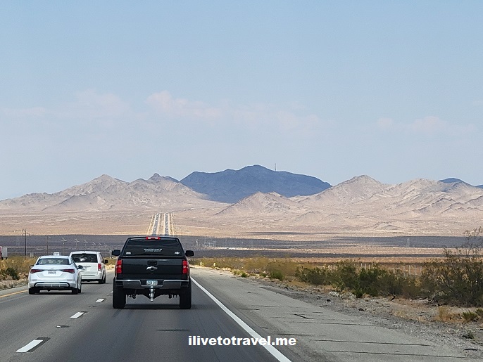
Cross-Country Drive Day 1 – San Jose, CA to Kingman, AZ

Last week I got to do the longest drive I have ever done: 5 days going from San Jose, California to Atlanta, Georgia. Why? I volunteered to help friends drive back to Atlanta as they leave California. It was not only a great opportunity to spend time together but also to see my country in a very different way of traveling: on the road!

Stats of the drive

First day: San Jose, California to Kingman, Arizona

Routes taken: California 101 to California 152 to I-5 to California 58 to I-40.

Departure time: 7AM

Arrival time: 4PM

License plates spotted: 30 states + 4 Canadian provinces (incl. Nova Scotia!)

Intra-California leg: San Jose to Bakersfield

Day 1 saw us departing San Jose, as you saw above, at 7AM. As I had arrive the night before from the East coast, that was not too early for me at all.

San Jose, window seat, California, great drive

Car loaded, we took some back roads (routes 101 and 152) to get onto I-5 at Los Banos. On the way there, we passed the town of Gilroy, which I am told is the world capital of garlic. Garlic IS in the air, even when the windows in the car are closed. Wikipedia says it is “the southernmost city in the San Francisco Bay area” but that seems a REAL geographical stretch to me (maybe it is a geological thing). Don’t believe everything you read! (The irony of that statement is not lost on me…) In any case, there were a large variety of crops like walnuts, almonds, and others confirming that this Central Valley indeed is a key source of produce.

I-5, I must say, is one tedious interstate to drive with the trucks and high volume of vehicles. I was glad when we got off it to head towards Bakersfield where we would take route 58 on the way to connecting with I-40 which would carry us, not only to the state border, but eventually all the way to Amarillo, Texas.

California Central Valley, produce, onion, trucks, cross-country drive

Southeastern California, Barstow and Route 66

After passing well-known Edwards Air Force Base, soon enough we hit our lunch stop at the crossroads of I-15 and one of the endpoints of I-40: the town of Barstow, California, right on Route 66. It was our first stop on Route 66. We were not trying to stick to Route 66 as we had days of driving to do but it was cool, at a couple of places, to see this famous route that carried so many out west in the 20th century.

Route 66, California, great drive, cross-country drive
Route 66, cross-country drive, California, Barstow
Barstow

To get to the border with Arizona, we first had to pass the Mojave area with the eponymous desert, Edwards AFB, and other facilities for military training and logistics. We also saw the lot where many airplanes are parked to not clutter airport space – it was odd to see so many planes in the middle of nowhere!

Hot Needles packing heat

It was a peculiar area and, of course, very hot. Temperatures hit 108F (42C). We thought that was outlandish but we were about to learn how reasonable 108F was.

As we took a southward turn on I-40 to go below Goose Lake

map, Goose Lake, Parker Junction, Needles
I-40 goes around the lake making a “U” that, on the right, will hit Kingman, AZ

… we passed the town of Needles and reached 120F (49C).

needles, california, extreme weather

Yea, that was hot; the car windows were very hot to the touch – from the inside of the air conditioned car… “Needles” to say (LOL), we did not get out of the car… But we enjoyed the views as usual.

Colorado River, route 66, cross-country drive, Arizona, California
Crossing the Colorado River between Needles and Kingman

The road traveled

We made it to Kingman where we stayed in the central (and older) part of town; more on that in the next post). We stayed at a Best Western that re-defined that brand for me – I was impressed with the cleanliness and freshness of the room and other facilities (I got nothing from saying that – that is just sharing my experience with you!).

To wrap up day 1, I will share a couple of pictures from the road and the vistas of southeastern California.

Southeastern California, route 66, cross-country drive
Finally in Arizona and a short drive left to Kingman!

Let’s see what happened and what was the destination on day 2 of this cross-country drive!

11 Places to See on the Oregon Coast

The Oregon coast stretches for over 360 miles (580 km) facing the mighty Pacific Ocean. To drive along the coast non-stop would take approximately seven hours on U.S. Route 101. Of course, stops are likely and recommended to plan well! We did the top third on one day, and the remaining on a second day.

Oregon coast, Pacific coast, beaches, Cape Sebastian, rock formations, great drive

Background on Oregon’s coast

The Oregon coast, as much of the Pacific coast of the United States, was first explored by the Spanish. Soon, thereafter the British (like Cook or Vancouver) also explored the Pacific Northwest coast. Most notably, the Lewis and Clark expedition got to the northwest corner of Oregon near Astoria.

The entire coast of Oregon is public land. Some technical terms define exactly how far from the water but the point is that all waterfront is public land and available for public use (while allowing for easements for coast-facing property owners).

This means that one can uninterruptedly explore the coast with its many features: beaches, rocky terrain, lighthouses, capes, historical sites, etc. There is a great variety of features dotting the coast allowing for a good number of activities for every taste (beach, hiking, small-town exploring, kite flying, water sports, fishing, and on and on).

There are different characteristics of the coast.

  • The northern segment is more likely to have longer, uninterrupted beaches. Cannon Beach and Tillamook would fall under this northern segment.
  • As you move further south, more small cliffs and terraces appear. Small neat towns like Yachats are part of this central coast adding more charm.
  • The southern part is more hilly so the cliffs and capes are taller. There are also beaches but they did not seem as vast as the northern ones. And sand dunes make their appearance in this section. Bandon and Coos Bay are some of the towns in this area.

Rocky outcrops dote the entire coastline, making it reminiscent of the Great Ocean Road in Australia near Melbourne. Sunset along the coast, needless to say, offers spectacular scenes and great photo opportunities.

What to see along Oregon’s coast

Here are some key spots to not miss among the many available. The list is presented in a north-to-south order, not in an order of preference!

#1 Cannon Beach

As expanded upon in a separate post in this blog, Cannon Beach is a must-see. It is expansive and easy to access from the town (steps away, literally!). Check out the blog post for a suggestion of what to do intown other than the beach that everyone checks out!

#2 Tillamook

Tillamook is a town near the coast. While it is on the water, it is actually a bay. It is a town of about 5,000 sporting an air museum and the Tillamook Creamery which can be visited. We did not make these stops as we had landed on the west coast around noon and had spent time in Cannon Beach and still had a long drive to get to the Willamette Valley for the evening.

#3 Munson Creek Falls

Right after passing Tillamook, for those wanting a little non-beach activity and beautiful nature, the Munson Creek Falls are easily accessible from U.S. Route 101 and a quarter mile short walk to get to them. The dense greenery makes a lot of sense given the high level of moisture of a coastal region. The trail to the waterfall starts at a small parking lot but the final bit of the trail happened to be close so we were not able to get up close-and-personal with the waterfall. Still, a nice break with lots of fresh air for our first travel day.

Oregon, Oregon coast, Pacific coast, beaches, great drive, hiking in Oregon, rock formations

#4 Boiler Bay State Scenic Viewpoint

There are many places to pull off the road or official viewpoints. The Boiler Bay stop, just north of Devil’s Punch Bowl, is one of the nicest in terms of the views it offers up the coast, but also because it is expansive, has tons of parking, and has restroom facilities. A nice place to stop and have lunch, stretch the legs, or shoot some good photos.

Oregon, Oregon coast, Pacific coast, beaches, great drive, cliffs, rock formations

#5 Devil’s Punch Bowl at Otter Rock

This amazing rock feature is easily reached but on a busy weekend day, good luck finding parking! The parking not only serves visitors who want to see the bowl but also those wanting to visit the local shops or head down to the amazing beach. Still it is worth the trouble. You can admire the bowl and follow a short trail that sort of is an overlook onto the beach right south of it. At the right time of the year (March/April, I understand), whale-watching may also be possible from there.

Oregon, Oregon coast, Pacific coast, beaches, great drive, cliffs, rock formations, Devil Punch Bowl

#6 Yaquina Head Lighthouse

Continuing on south, the Yaquina Head Lighthouse (the tallest on the coast) is a great spot to stop and explore. When we went, we were not able to drive up to the parking area by the lighthouse itself but had to park up the road and undertake a walk that was not unpleasant.

Oregon, Oregon coast, Pacific coast, lighthouse, great drive, cliffs, rock formations

By the lighthouse you can walk to decks along the cliff to get closer to the water. Access to the ‘beach’ was closed, not sure why (Covid gives a great cover to change a few things…). But we were close enough at the lowest deck while also getting a better look at the birds nesting on the rocks. I also recommend reading the signs explaining a few topics, especially how looking at the cliff-side and the rocks shows you how much time a particular level spends underwater as the tide comes and goes.

Oregon coast, Pacific coast, beaches, great drive, cliffs, rock formations, Oregon lighthouse

The lighthouse was off limits but I don’t think that was Covid but, rather, repairs that were underway. Again, signs explain how the area and life there were in its very early days. Really interesting life those folks led! As with many lighthouses, they are now automated and the full-time lighthouse operator is no longer the human who tended to live a very isolated life in those locales.

#7 Yachats

The small town of Yachats is one of the more picturesque of the towns I got to see along the coast. It is a great stop to have lunch near the water (even if not facing it) and perhaps shop around at the local market (can’t quite call it a supermarket though it has just about everything one needs) or the stores around the heart of the town. Yachats is the entry point (at least in this direction) to the next area worth exploring….

Oregon, Oregon coast, Pacific coast, beaches, great drive, Yachats

#8 Cape Perpetua

Cape Perpetua (visited and named by James Cook in 1778) is not just a cape point but a broader area. The day use area offers great views. The beaches around are expansive. Thor’s Well is one of the many interesting features to explore. Campgrounds and walking/hiking trails offer more than just views. In other words, plenty of things to see and places to soak the beauty of the Oregon coast in. Before my trip I read somewhere that is the quintessential coast of Oregon everyone thinks of when they talk about how beautiful the Pacific coast is. Agreed!

Cape Perpetua, Oregon coast, Pacific coast, beaches, great drive, cliffs, rock formations

#9 Oregon Sand Dunes

I never fully figured out the best spot(s) to view and enjoy the sand dunes of Oregon but everything I had read spoke about the amazing dunes of Oregon. Clearly, I needed to have done more research – or have better luck on the road! I had supposed it was one park with a nice brown sign along the road pointing to where to go. Well, it seems the area is so expansive that it is not just “one” spot. In any case, do your homework on these if you are interested. Know that you will see some sand dunes along the way all the way into California though perhaps not the most impressive part.

Oregon, Oregon coast, Pacific coast, beaches, great drive, Oregon sand dunes

#10 Cape Sebastian

Cape Sebastian has multiple places to explore but the south parking offered, in my opinion, one of the best vantage points to see up and down the coast. I read it was just about 50 miles up and down of views from about 200 feet high! Truly stunning.

hiking in Oregon, Oregon coast, Cape Sebastian, nature, adventure in Oregon
View from the north parking lot viewpoint
hiking in Oregon, Oregon coast, Cape Sebastian, nature, adventure in Oregon
View from the trail off the south parking looking north
hiking in Oregon, Oregon coast, Cape Sebastian, adventure in Oregon, Hunter's Cove, Myers Creek Beach
View from the trail off the south parking looking south towards Myers Creek beach

We were running behind schedule so we limited our walk on the trail off the parking lot but it was a fun, vegetation-covered trail on the segment we did.

hiking in Oregon, Oregon coast, Cape Sebastian, nature, adventure in Oregon
The trail off the south parking lot

#11 Myers Creek Beach

Right after getting down from Cape Sebastian and hopping on the 101, there are a couple of viewpoint stops to admire the beach and rock formations and, in our visit, the setting sun and its great light for photos. We stopped at the second one, the Myers Creek Beach viewpoint, closer down to the beach level though not quite there. The sand looked like small sand dunes with the shadows they cast. I figure whichever stop along the coast you make while the sun is setting may be your favorite stop. I think Cape Sebastian and this stop, therefore, may be my favorite of the entire coast!

Myers Creek Beach, Oregon sunset, sand dunes, Oregon beach, Pacific coast, route 101, Cape Sebastian

Hope you get to explore the Oregon coast someday and certainly do not limit yourself to this list – there is more than I could cover and more for every taste / preference!

Oregon coast, sunset over the Pacific, Pacific coast, Cape Sebastian, hiking, great drive, route 101

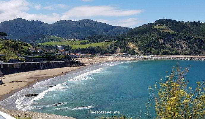
In Search of Andraka in Spain’s Beautiful Basque Country

One of the reasons for my recent trip to Spain, as I shared in an earlier post, was to see the ancestral lands of my Mom’s family in the Basque region of Spain (Euskal Herria in Basque).  My Mom’s last name (Andraca, in Spanish) is the name of a home that existed a long time ago where the family originated near Bilbao, Spain in the province called Bizkaia (or Vizcaya or Biscay).  We wanted to see the place but it was only one of many places we had in our roughly-sketched family tree (which also included the neighboring province of Guipuzkoa).  So, since we were not going to just one place, we decided to take a full day and just drive around these two provinces and take in the landscape of Spain’s Basque country…

All the towns in our Basque country…

Our family tree shows a lot of ancestors coming from the provinces of Bizkaia and Guipuzkoa, two of the Basque region’s provinces.  Many of their last names are the names of villages or towns spread about these provinces.  And, when not, we know which towns they came from.  Places like Bergara, Gorliz, Lekeitio, Ondarroa, Azpeitia, Azkoitia, and others feature prominently in our family history.  We definitely would not be able to hit each and everyone one of these due to time limitations and would only stop at a few even if we passed by them.  But it is not like we would have discovered unknown cousins (first, second or even fourth) – our ancestor who came from Spain to Cuba got to Cuba in 1800 so too far in the past for any real connection with living descendants of his own ancestors…

Zarautz – Beach town

We left San Sebastian, our base for a couple of days, and headed west following more or less the coast.  We had no set plans of where we would stop along the way.  One of the first places we passed caught our eye and we decided to see if we could find parking and get out and walk around some.  This place was Zarautz, a beach town of about 20,000 15km (9 mi) west of San Sebastian, that felt like a very livable place, not just a beach town for visitors.  (The town connects to San Sebastian and Bilbao by train so even if one is not driving there, one can get there on public transport.)

Euskal Herria, Basque, Spain, Espana, Zarautz, Andraka, Bizkaia, Vizcaya, Guipuzkoa, driving, Bay of Biscay, Samsung Galalxy S7

The beach

Euskal Herria, Basque, Spain, Espana, Zarautz, Andraka, Bizkaia, Vizcaya, Guipuzkoa, driving, Bay of Biscay, Samsung Galalxy S7

West end of the beach

The beach was long (I read it is about 2.8 km long; the longest in that coastline) and we could certainly see how it would be an appealing tourist destination.  The beach was not packed and it may be that it was likely already the end of the season (but finding street parking was impossible still!).  We sat in the plaza above the underground parking deck and looked out at the beach and ocean.  My Mom, uncle and I decided to walk down to get our feet wet by the waters of the Bay of Biscay as maybe our ancestors did somewhere up or down that coast many centuries ago…

Euskal Herria, Basque, Spain, Espana, Zarautz, Andraka, Bizkaia, Vizcaya, Guipuzkoa, driving, Bay of Biscay, Samsung Galalxy S7

Mom and uncle walking to the water!

Euskal Herria, Basque, Spain, Espana, Zarautz, Andraka, Bizkaia, Vizcaya, Guipuzkoa, driving, Bay of Biscay, Samsung Galalxy S7

16th century Palacio de Narros from the beach

Euskal Herria, Basque, Spain, Espana, Zarautz, Andraka, Bizkaia, Vizcaya, Guipuzkoa, driving, Bay of Biscay, Samsung Galalxy S7

Conveniently located to wash one’s feet after stepping on the beach

Euskal Herria, Basque, Spain, Espana, Zarautz, Andraka, Bizkaia, Vizcaya, Guipuzkoa, driving, Bay of Biscay, Samsung Galalxy S7

My sis and uncle enjoying the view

More Basque coastline

We both reluctantly and eagerly got back in the car.  Zarautz was worth staying but we had a key objective for the day ahead…  We drove from Zarautz past Getaria (another great-looking coastal town) and, somewhere around Zumaia, turned inland on the road.  It was disappointing to leave the beautiful coast because, as you can see, it was beautiful.

Euskal Herria, Basque, Spain, Espana, Zarautz, Andraka, Bizkaia, Vizcaya, Guipuzkoa, driving, Bay of Biscay, Samsung Galalxy S7

Yet another great beach west of Zarautz by Getaria

Euskal Herria, Basque, Spain, Espana, Zarautz, Andraka, Bizkaia, Vizcaya, Guipuzkoa, driving, Bay of Biscay, Samsung Galalxy S7

Nice curvy road bordering hills that face the water

Euskal Herria, Basque, Spain, Espana, Zarautz, Andraka, Bizkaia, Vizcaya, Guipuzkoa, driving, Bay of Biscay, Samsung Galalxy S7

Basque coastline beauty!

A phenomenal Basque lunch

We kept driving and after a failed attempt to reach Lekeitio (there was some festival that weekend with all roads leading to it blocked of – very disappointing as it was high on our list), we went inland.  And hunger was hitting… During a routine bathroom stop at a local bar in the town of Ereño (between Lekeitio and Bermeo but inland), my Mom came and told us the place had a restaurant and it had customers (my cardinal rule is to never go into an empty restaurant in an unknown town…).  The place was cozy, on the ground level of a 2- or 3-story building (can’t recall).  It was Restaurante Jatetxea Atxoste.

Euskal Herria, Basque, Spain, Espana, Zarautz, Andraka, Bizkaia, Vizcaya, Guipuzkoa, driving, Bay of Biscay, Samsung Galalxy S7

The place we had lunch at in Ereño

It was SUPERB.  The thing I liked the most is the one I did not take a picture of:  the fresh cod sauteed with spinach.  It would be the single most delicious dish I had in the entire trip!  But captured for posterity were the red beans and the rice pudding which were excellent.

Euskal Herria, Basque, Spain, Espana, Zarautz, Andraka, Bizkaia, Vizcaya, Guipuzkoa, driving, Bay of Biscay, Samsung Galalxy S7

Rice pudding dessert

Euskal Herria, Basque, Spain, Espana, Zarautz, Andraka, Bizkaia, Vizcaya, Guipuzkoa, driving, Bay of Biscay, Samsung Galalxy S7, food, red beans

The red beans – I could just have ate them all!

I always prefer the small mom-and-pop places where, though service may not be stellar, the food typically is.  Great find, Mom!!

Driving through history:  Guernica

After lunch, on our way to Andraka, we made it a point to drive through the town of Guernica which suffered a massive air attack during Spain’s Civil War in 1937 by Nazi Germany, a bombing that lasted about 2 hours.  Picasso captured the pain and horror of that moment in history in a famous painting named after the town.  There is a mural in the town center matching the painting.  We did not plan to get out of the car but I did snap a quick side photo of the mural…

Guernica, Spanish Civil War, Basque, Spain, Gernika, bombing

The mural

Guerica, Gernika, Pabo Picasso, Guerra Civil, Spanish Civil War, Spain

Guernica by Pablo Picasso

The main event:  Andraka

Andraka is not a town by my definition; not even a village, just some homes laying around (a few under construction) and a restaurant right by the road.  But it has the typical European signs announcing the ‘town’ and letting you know when are leaving the ‘town.’  If there was an original home from over 200 years ago that could have been our ancestros’, we did not see it; and that really didn’t matter that much to us.  After a quick walk around an old, abandoned house and snapping a couple of pix by signs that said “Andraka,” we got back in the car and continued on our drive, satisfied we had gotten to that area of Bizkaia where the last name Andraca originated for our family…

Andraka, Bizkaia, Basque, Vizcaya, hamlet, ancestors, family history, Spain, travel

How the area of Andraka looks

Andraka, Bizkaia, Basque, Vizcaya, hamlet, ancestors, family history, Spain, travel

The old home taken over by vegetation

Andraka, Bizkaia, Basque, Vizcaya, hamlet, ancestors, family history, Spain, travel

My uncle

Andraka, Bizkaia, Basque, Vizcaya, hamlet, ancestors, family history, Spain, travel

Mom, sister and yours truly

A truly unique and fun experience to have shared with loved ones!


Drive the amazing Basque coast!  Pin this to your travel board!

Basque, coast, coastline, vasco, Bilbao, San Sebastian, Spain, España


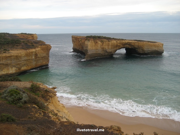
Along the Great Ocean Road in Australia

The trip to see the Twelve Apostles and the Great Ocean Road, near Melbourne, Australia started at Federation Square (across from St. Paul’s Cathedral) where I got to see the possible tour options at the tourism office located there.

Melbourne, Flinders, train station, Australia, photo, travel

Flinders Train Station, across from Federation Square

I returned there to take the bus on the day of the tour and a long but rewarding day began.  Along the way we stopped to see some of the flora and the wildlife (koalas, kangaroos and birds).  It was amazing to see koalas and kangaroos just freely roaming around, not in a zoo or animal park.

fern, Australia, flora, vegetation, photo, green, travel

Close-up of a fern in the park where we stopped to see the koalas

Kangaroo, Australia, Melbourne, Great Ocean Road, wildlife, tour,

Kangaroos roaming (or hopping) free along the Great Ocean Road

bird, Australia, Melbourne, Great Ocean Road, wildlife, tour,

Colorful bird!

koala, Australia, Melbourne, Great Ocean Road, wildlife, tour,

Koala doing what they do best: sleep. Tons of sleep.

The Twelve Apostles (who knows if there are really 12 at any given point, one of the more famous ones had collapsed not long before my visit) are fascinating as they “show” the process of water and wind shaping our landscapes.

Twelve Apostles, Melbourne, Australia, Great Ocean Road, park

A nice park has been set up to help see the Twelve Apostles

As the water washes away softer terrain, these “islands” of stone become separated from the mainland.  Great Ocean Road, Melbourne, Australia, sea, photos, Twelve Apostles

You can tell where new ones will appear:  any of those fingers or peninsulas are apostles-in-the-making.

Great Ocean Road, Melbourne, Australia, sea, photos, Twelve Apostles

At some point, the underside of a finger begins to hollow until an arch forms.  The arch eventually collapses separating part of the former peninsula from the mainland (see next photo).  In turn, an arch may form on the newly-formed “island” and, when the arch collapses, it will just leave just a column which over time will also collapse leaving nothing behind.  The cycle of life!

Great Ocean Road, Melbourne, Australia, sea, photos, Twelve Apostles

Here is a finger where a part collapsed creating an “island” arch

Great Ocean Road, Melbourne, Australia, sea, photos, Twelve Apostles

By now, this “island” has become quite isolated and is developing an arch that will further weaken it

Great Ocean Road, Melbourne, Australia, sea, photos, Twelve Apostles

Columns in the water: former arches, former fingers, former mainland!

Now, the park has very easy trails to walk and get good vantage points, and the tour goes to other interesting spots such as Loch and Gorge.

Great Ocean Road, Melbourne, Australia, sea, photos, Twelve Apostles

Loch and Gorge

But what really captivated me was the brief helicopter ride to see the apostles from above.  I had never ridden a helicopter before so there was a double thrill aspect to the experience for me.

Great Ocean Road, Melbourne, Australia, sea, photos, Twelve Apostles

Viewing them from high was a real treat

Finally, if you decide to drive the Great Ocean Road and you are not from Australia or the U.K. (or some other places like them), please mind what this sign says as you explore this beautiful road!road sign, great ocean road, australia, driving, photo

%d bloggers like this: