Day 2 on the Jotunheimen NP Circuit Hike

Having survived the first day of a 6-hike circuit – and the longest hike of the 6 -, it was time to get going on Day 2 for the next challenge: getting to Spiterstulen by climbing Glittertind mountain (vs. skirting it and going around it).

Tallest mountains in Norway and northern Europe

Glittertind is not only the second tallest mountain in Norway but in all of northern Europe. Glittertind stands at 2,452 m / 8,045 ft. The tallest mountain is nearby: Galdhøpiggen. It stands a modest 17 m / 56 ft taller than Glittertind. The height of these mountains is a little higher if you include the glaciers atop. For example, Glittertind, back in 2008, stood at 2,465 m counting the glacier.

Heading up Glittertind

We started the morning early with breakfast at 7:30AM and a departure from Glitterheim at 8:40AM. Though Glittertind stands at 2,452 m, Glitterheim itself is location at around 1,400 M above sea level. So we sort of had a head start in terms of the climb. Small mercies!

Glitterheim turisthytte, cabin in Jotunheimen, hiking in Norway, trekking, senderismo en Noruega, Norge, norvege
Leaving Glitterheim behind

The climb to the summit was about 3.8 miles. The first mile would ascend 425 ft. The second mile would go another 500 ft. Finally, the third mile would go another 450 ft. The final bit to the top would take us up approximately another 300 ft. I cannot recall for certain but it feels the last 1.5 mile was a pure rock walk. Steep and painfully slow to navigate stepping over all those rocks

rock fields, challenging hiking terrain, trekking in Norway, senderismo en Noruega, Jotunheimen, Den Norske Forening, DNT, Glittertind, Glitterheim, Spiterstulen
Norway may be also called Rocks ‘R Us
Glittertind, rock field in Jotunheimen, senderismo en Noruega, trekking i Norge, Norway hike, Spiterstulen,  Glitterheim
Can you still spot me in the rock field? Fun times

Atop Glittertind and all that snow

Within the last hour of the climb, it started to snow. Visibility decreased but we could still see where we were and where we were headed.

Glittertind, rock field in Jotunheimen, senderismo en Noruega, trekking i Norge, Norway hike, Spiterstulen,  Glitterheim
Can you see me now?
rock fields, challenging hiking terrain, trekking in Norway, senderismo en Noruega, Jotunheimen, Den Norske Forening, DNT, Glittertind, Glitterheim, Spiterstulen. snow
I could still see my friend (red oval above) so all was good.

Good thing because right by the summit there was a cliff we could not see… (see image below from AllTrails). Good thing that snowpack at the top was rock solid!

AllTrails, Glittertind, hiking in Norway, trekking in Jotunheimen, snowpack, glacier in Norway, Norge, DNT
This screenshot right after the summit
rock fields, challenging hiking terrain, trekking in Norway, senderismo en Noruega, Jotunheimen, Den Norske Forening, DNT, Glittertind, Glitterheim, Spiterstulen
At THE summit

Descending not always fun and games

Once we were done resting at the summit, we began the descent. For a little bit, we were still on the glacier / snowpack. We did not have any special attachments on our hiking boots. I just made sure I stepped where someone else had stepped before me, hoping the snow had compacted all it was going to compact thanks to the prior person. Oh, and that I was not going to step on snow that was sitting on top of a crevice or gap of some sort!

You can visualize in this AllTrails’ trail preview how sharp a descent this was (it began around mile 4.1, soon after leaving the summit ridge.

AllTrails, Glittertind, hiking in Norway, trekking in Jotunheimen, snowpack, glacier in Norway, Norge, DNT
steep descent, challenging hiking terrain, trekking in Norway, senderismo en Noruega, Jotunheimen, Den Norske Forening, DNT, Glittertind, Glitterheim, Spiterstulen
What it looked like in real life

Eventually, after left the summit ridge, the terrain was free of snow and the snow stopped falling. Back to our normal steep-descent-with-lots-of-rocks-and-scree. It was the usual very focused walk to avoid a nasty and painful fall.

steep descent, challenging hiking terrain, trekking in Norway, senderismo en Noruega, Jotunheimen, Den Norske Forening, DNT, Glittertind, Glitterheim, Spiterstulen
Just too awe-inspiring to not post another photo!
ilivetotravel, Spiterstulen turisthytte, lodging in Jotunheimen, cabin in Jotunheimen, Lomb beer, Norge, senderismo en Noruega

The challenging, steep descent from Glittertind is over

After the steep descent, we entered the area that you see in the picture above. We followed a stream for a bit on still-rocky terrain for a bit.

norvege, Spiterstulen turisthytte, lodging in Jotunheimen, cabin in Jotunheimen, Lomb beer, Norge, senderismo en Noruega
The descent is over!!
challenging hiking terrain, trekking in Norway, senderismo en Noruega, Jotunheimen, Den Norske Forening, DNT, Glittertind, Glitterheim, Spiterstulen

We then went up a little bit and rounded some mountain to a trail that would eventually parallel the private road leading to Spiterstulen. I so badly wanted to just get to that road and walk on a flat, smooth surface! But, it was not to be until the very end, close up to Spiterstulen. To add insult to injury, after we got on the road and approached the lodge, we had a slight uphill. Really…. 🙂

Regardless, my buddy and I were very happy hikers by the time we got to Spiterstulen!

challenging hiking terrain, trekking in Norway, senderismo en Noruega, Jotunheimen, Den Norske Forening, DNT, Glittertind, Glitterheim, Spiterstulen, ilivetotravel

How to end a hard hike

Thankfully, Spiterstulen was ready for us! From a refreshing cold beer to a great meal to a great space in the room and the large lounging room – Spiterstulen was great.

ilivetotravel, Spiterstulen turisthytte, lodging in Jotunheimen, cabin in Jotunheimen, Lomb beer, Norge, senderismo en Noruega
Spiterstulen from the outside
ilivetotravel, Spiterstulen turisthytte, lodging in Jotunheimen, cabin in Jotunheimen, Lomb beer, Norge, senderismo en Noruega

Our room was actually in a cabin and we enjoyed a private bathroom (with heated floor!), a small living room area and a great view from the room’s window. Perfect spot to chill and re-charge.

ilivetotravel, Spiterstulen turisthytte, lodging in Jotunheimen, cabin in Jotunheimen, Lomb beer, Norge, senderismo en Noruega

The meal started with salmon on a piece of bread (that could have been the entrée!). Then Norwegian meatballs with veggies, chased by diced watermelon topped with vanilla ice cream. All good!

foodporn, Spiterstulen turisthytte, lodging in Jotunheimen, cabin in Jotunheimen, Lomb beer, Norge, senderismo en Noruega

Norway’s beauty is infinite!

I am writing all this post-facto, a couple of weeks after returning home. The majesty of the landscapes of Norway are, maybe not unique, but definitely spectacular. Just a view like below, after a nice meal and a beer (or two), are enough to make one be in awe of God’s creation…

ilivetotravel, Spiterstulen turisthytte, lodging in Jotunheimen, cabin in Jotunheimen, Lomb beer, Norge, senderismo en Noruega

Check out Day 1 (Gjendesheim to Glitterheim)

Or, read on to Day 3 (Spiterstulen to Leirvassbu)

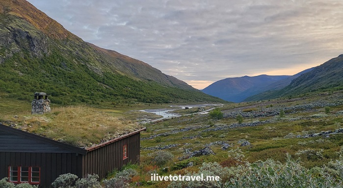
A Cool Hiking Circuit in Norway: Jotunheimen National Park

I recently had the good fortune to be able to go to Norway to do a hiking circuit in Jotunheimen National Park. Jotunheimen is northeast of Bergen, about halfway between the Atlantic Ocean and the Swedish border.

The park offers a wide range of opportunities to explore nature and experience it any way you want. These range from easy & short hikes to long & challenging ones. It is also possible to drive to some of the cabins/huts and just do short walks and enjoy the scenery around the cabins/huts. Oh, and some of the cabins/huts are worth spending time at!

Hiking Circuit in Jotunheimen, norway, norge, nature, lake

Our hiking circuit in Jotunheimen – options

A friend of mine had hiked in Jotunheimen before and suggested a hiking circuit for us to do over a period of 6 days. There were options in terms of:

  • which direction (clockwise/counterclockwise)
  • starting point (which of the driving accessible cabins/huts)
  • ending point (either the same as the starting point or another, coupled with a ferry ride to get back to the starting point)
  • cabin-to-cabin itineraries
  • routes options within a cabin-to-cabin route.

Our hiking circuit in Jotunheimen – starting point and direction

We opted to start in Gjendesheim as it afforded an early start if we stayed right there vs. ferrying to Memurubu or Gjendebu. That meant an earlier start than most people who would be doing hikes on that day. The trails ended up not being that crowded at all but I still liked the early start!

Gjendesheim also has a nearby long-term parking about a mile away which was good since we had decided to rent and hold the car while we spent the week in the park.

In terms of the direction, my friend had done counter-clockwise before and strongly believed that to the best way to tackle the circuit. For me, it was good getting the longest segment out of the way on the first day (which had the downside of doing the longest day when still not fully “warmed up”).

Our hiking circuit in Jotunheimen – the route

So with Gjendesheim being the starting point and the direction being counterclockwise, the obvious first cabin/hut was Glitterheim. This meant the 14-mile hike.

The next stop was obvious: Spiterstulen. However, the question was how to get to Spiterstulen. See, there were two options there:

  • Hike up to summit Glittertind, northern Europe’s second highest peak, OR
  • Hike around Glittertind.

We opted to summit Glittertind, weather-permitting, as it would be great to have the experience of summitting.

From Spiterstulen, the best option is Leirvassbu. This was my favorite trail but more on that in a later post!

From Leirvassbu, our best option on the loop we were going for was to head to Gjendebu on the shores of Gjende Lake.

From there, there is the option to skip out on the rest of the circuit and take the ferry to Gjendesheim (or even to Memurubu). We, of course, wanted to hike to Memurubu. That is a story onto itself…

Finally, from Memurubu the options included the ferry, the Bessegen route, and the shore-side trail. We opted for the latter and that story will be in a future post!

Hiking Circuit in Jotunheimen, norway, norge, nature, lake

Our hiking circuit in Jotunheimen – the summary

  • Day 1: Gjendesheim -> Glitterheim (14 miles) -> read about it here
  • Day 2: Glitterheim -> Spiterstulen (via Glittertind) (11 miles) -> read about it here
  • Day 3: Spiterstulen -> Leirvassbu (12 miles) -> read about it here
  • Day 4: Leirvassbu -> Gjendebu (10 miles) -> read about it here
  • Day 5: Gjendebu -> Memurubu (6.7 miles) -> read about it here
  • Day 6: Memurubu -> Gjendesheim (6.6 miles) -> read about it here

For me, in hindsight, this itinerary forced me to do the hardest work upfront (days 1 and 2) and having “easier” hikes on the remaining days. Don’t be fooled when I say “easier”. None are a walk in the park by a long stretch!

There is no right or wrong way to do Jotunheimen but I can certainly say this route worked really well for me!


Check out the park’s website here.

%d bloggers like this: