Two Days Exploring Canyonlands, a Mighty Five National Park Powerhouse!

Canyonlands seems endless: truly a Mighty Five National Park! Along with Arches, Zion, Bryce Canyon, and Capital Reef, it is one of the Mighty 5 U.S. National Parks in Utah.

Canyonland National Park is located near Moab, Utah and not far from Arches National Park, it is far from from a major airport but certainly worth the effort. We spent two days exploring Canyonlands which was perfect in the context of our broader trip covering the Mighty Five.

Attacking Canyonlands: Island in the Sky District

The park is made of several districts with Island in the Sky being easily the most accessible and with a lot to offer to hikers and non-hikers alike. It was easy to spend two days and leave territory not-covered, even just in Island in the Sky. This district’s main roads are in the form of a “Y”. One enters on the top right of the Y, the only entrance/exit to this district (with a main paved road).

We had dedicated two days to Canyonlands, the second of the Mighty Five U.S. National Parks we were visiting on this hiking trip. We decided to split the visit as follows:

  • Day 1: The lower leg of the Y, starting by going all the way to the bottom and making our way back up (and out). On this day, we visited the following:
    • Orange Cliffs Overlook facing the Green River
    • Buck Canyon Overlook facing the Colorado River
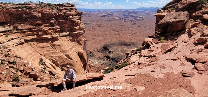
    • Grand View Point Overlook walking along the rim
    • Murphy Trail.
  • Day 2: The upper part of the Y, starting at the far end of the left upper arm of the Y. These were all short hikes, easily accessible.
    • Upheaval Dome
    • Whale Rock
    • Aztec Butte
    • Mesa Arch
    • Shafer Canyon Overlook.
Great VIew Point Overlook, Canyonlands National Park, Green River, Colorado River, Utah hiking, Orange Cliffs
Easily accessible Orange Cliffs Overlook view!

Grand View Point Overlook and a good intro to Canyonlands

After stopping at the Orange Cliffs and Buck Canyon Overlooks, we proceeded to Grand View Point Overlook. As we entered the trail, we happened upon a 10 AM outdoor park ranger talk. Very fortunate as I learned a lot about the major forces that shaped the terrain and created the multiple layers of different colors and compositions we see today.

Great VIew Point Overlook, Canyonlands National Park, Green River, Colorado River, Utah hiking

Great VIew Point Overlook, Canyonlands National Park, Green River, Colorado River, Utah hiking

The trail to the overlook was a short and highly rewarding 1.8 mi walk along the canyon rim with little elevation gain though you are in an altitude of ~6,000 ft. There is a short rock climb to get to the best viewpoint – and great spot for photos!

Great VIew Point Overlook, Canyonlands National Park, Green River, Colorado River, Utah hiking

Great VIew Point Overlook, Canyonlands National Park, Green River, Colorado River, Utah hiking

Wrapping up day 1: Murphy Trail

Murphy Trail was going to be our strenuous hike on this day. Not because of the length, as it was not too long (a 4.5-mile hike), but because we started in the afternoon and it was one very hot day. On and it would be steep with an elevation gain of 1,109 ft. The initial part of the trail was a walk on a field that did not have much to say in its favor. But then we reached the edge and began the best part of this fun hike. The terrain included rock scrambles and the like, and the view was always breathtaking once we left the field.

Murphy Trail, Canyonlands National Park, parks in Utah, hiking in Utah, outdoors, canyon hikes, outdoors, adventure

Murphy Trail, Canyonlands National Park, parks in Utah, hiking in Utah, outdoors, canyon hikes, outdoors, adventure
Down and up all those rocks

Murphy Trail, Canyonlands National Park, parks in Utah, hiking in Utah, outdoors, canyon hikes, outdoors, adventure

Once we got to the connector to the loop trail at the bottom, we stopped for lunch (at the “green” rock level) before beginning he hike back up to the rim. Though it was a very hot day, with good hydration and electrolytes, we did it safely and greatly enjoyed the hike: navigating the rocks, the descent/ascent, and the great vistas and rock formations.

Murphy Trail, Canyonlands National Park, parks in Utah, hiking in Utah, outdoors, canyon hikes, outdoors, adventure
The little green area at the bottom was our lunch spot

Certainly, a few degrees cooler would have been nice. But the ice cold water awaiting for us in the cooler we had in the car felt like heaven as I poured it over my head and feet!

Upheaval Dome

Day 2 was not going to be the strenuous hike day, but a day full of moderate or easy relatively short hikes for us. Upheaval Dome was our first destination of the day.

There were two overlooks, the first of which was about halfway in. The trail, an in-and-out, was only only 1.3 miles but with 226 ft elevation gain. Not strenuous at all but providing a great vantage point to look at Upheaval Dome. It was unlike any sight we saw or were going to see during our time in the park. It was a circular hole, as in a volcano’s caldera or a crater, but inside there were massive, tilted rock formations of a greenish color.

upheaval dome, canyonlands, hiking, rock formations, utah, southwestern parks

Whale Rock

Right by Upheaval Dome was Whale Rock. No explanation needed for its name… It is about a 0.8-mil trail roundtrip though we tooled around a little so maybe it was a mile for us. Elevation gain is 128 ft to the top. Not strenuous but has a steep spot that some may take slow. It offers a good view of Island in the Sky with little effort. Just because a trail is short it does not mean shoes with good traction are not necessary: always good to have them because of the sloped nature of some of the rocks one will walk on on trails like Whale Rock.

whale rock,, canyonlands national park, parks in utah, hiking, rock formations, southwestern US, nature
View of the road from Whale Rock

Aztec Butte

The walk to Aztec Butte was not that exciting but the climb to the top of the butte offered a nice challenge with a very steep rock face.

aztec butte, canyonlands, hiking in utah, rock formations, southwestern parks

aztec butte, canyonlands, hiking in utah, rock formations, southwestern parks
Steep and cool rock layers along the route

Right below the top are small “caves” that I imagine were used by people long ago. I read that they were used to store grains and other food.

aztec butte, canyonlands, hiking in utah, rock formations, southwestern parks
Cavemen

The roundtrip is about 1.4 miles with 213 ft elevation gain (all when the butte is reached). Great views from the top.

aztec butte, canyonlands, hiking in utah, rock formations, southwestern parks

And, no, no Aztecs lived in the area…

Mesa Arch

The combination of a short hike at 0.83 miles and the amazing structure of Mesa Arch make this a definite must-see. Only 102 ft elevation gain to boot so relatively easy. It does require, though, walking on rough terrain and stones. But, through the arch ones has a great view of the canyons below and the La Sal Mountains afar.

aztec butte, canyonlands, hiking in utah, rock formations, southwestern parks, mesa arch

aztec butte, canyonlands, hiking in utah, rock formations, southwestern parks, mesa arch
Having some fun: on the same photo in two places!

Canyonlands is a phenomenal place for all, hikers and non-hikers alike. The beauty of the canyons is outstanding. The Colorado and Green Rivers add to the scenery as they snake their way down the canyons. But what certainly caught my eye was the variety of colors across the many layers of rock exposed for us to see!

Great Drive Series – Along the Columbia River in Oregon

Oregon has been a place I have always been wanting to go.  When the opportunity to go on a business trip to Portland arose, I was thrilled.  Though I was not able to append a weekend on either end of the business trip to get to explore more, I did have a Sunday afternoon and the hours after office hours to check some of the area.

My favorite part was driving along the Columbia River Gorge.  I had not read up much about the area before going and it surprised to discover there was a gorge along parts of the Columbia River, near Portland.  I discovered it by looking outside my seat window as we were close to land in PDX.  I was very lucky to have picked a window seat (I am a serial aisler) and that it was on the right side of the plane which not only afforded me the opportunity to discover the gorge but also to see Mt. St. Helens and Mt. Adams.  (Clearly, the airplane’s window was a little dirty and, seemingly, so was the air right above – notice the brownish line killing my clear view of the top of Mt. St. Helens).

Mt St Helens, Mt Adams, Columbia River, Columbia River gorge, airplane view, travel, photo, Samsung Galaxy

Mt. St. Helens on the left, Mt. Adams on the right; the Columbia River and the gorge in the middle

Mt St Helens, Mt Adams, Columbia River, Columbia River gorge, airplane view, travel, photo, Samsung Galaxy, Portland, Oregon

Close up of the mountains (and the window smudge!)

Getting to the Columbia River Gorge from Portland was very easy.  Just take I-84 East.  To visit the most famous of the waterfalls, Multnomah, one doesn’t even really have to get off the interstate:  there is a parking area in the middle of the interstate (a rest area) and a tunnel under the lanes to get to the waterfall.

Portland, Columbia River, Oregon, Multnomah Falls, gorge, scenic, nature, outdoors, Samsung Galaxy, photo, travel

At the top of the photo, you can see the rest area

But it is nicer to get off earlier (at Troutdale or Corbett) and then do the scenic route, passing other waterfalls along the way.  The scenery is beautiful.Portland, Columbia River, Oregon, Multnomah Falls, gorge, scenic, nature, outdoors, Samsung Galaxy, photo, travel Portland, Columbia River, Oregon, Multnomah Falls, gorge, scenic, nature, outdoors, Samsung Galaxy, photo, travel Portland, Columbia River, Oregon, Multnomah Falls, gorge, scenic, nature, outdoors, Samsung Galaxy, photo, travel Portland, Columbia River, Oregon, Multnomah Falls, gorge, scenic, nature, outdoors, Samsung Galaxy, photo, travel

The first main stop is phenomenal:  Vista House on the Crown Point Scenic Corridor.  You enjoy great vistas up- and down-river of the Columbia River from this high vantage point.  I wish I had been there for sunrise or sunset (or both) – bet the view would have been even better!Columbia River, Portland, Oregon, gorge, Vista House, nature, outdoors, travel, Samsung Galaxy, photoColumbia River, Portland, Oregon, gorge, Vista House, nature, outdoors, travel, Samsung Galaxy, photo Columbia River, Portland, Oregon, gorge, Vista House, nature, outdoors, travel, Samsung Galaxy, photo Columbia River, Portland, Oregon, gorge, Vista House, nature, outdoors, travel, Samsung Galaxy, photo Columbia River, Portland, Oregon, gorge, Vista House, nature, outdoors, travel, Samsung Galaxy, photo, vista

After Vista House continuing eastbound, a series of waterfalls come before getting to Multnomah Falls, the tallest falls in the state.  There are several trails available to get out and walk.  I reserved my limited time to go up the Multnomah Falls which rises over 600 ft.  Multnomah, falls, waterfalls, Oregon, Columbia River, gorge, scenic drive, outdoors, nature, travel, photo, Samsung Galaxy

I did the round trip up and down in slightly less than an hour.  It is nice they numbered the switchbacks going up but it certainly made me anxious to get to the last one – I’d rather not know how many I have left!

Latourell Falls on the left and Multnomah Falls on the right

Latourell Falls on the left and Multnomah Falls on the right

Multnomah, falls, waterfalls, Oregon, Columbia River, gorge, scenic drive, outdoors, nature, travel, photo, Samsung Galaxy Multnomah, falls, waterfalls, Oregon, Columbia River, gorge, scenic drive, outdoors, nature, travel, photo, Samsung Galaxy Multnomah, falls, waterfalls, Oregon, Columbia River, gorge, scenic drive, outdoors, nature, travel, photo, Samsung Galaxy

Multnomah, falls, waterfalls, Oregon, Columbia River, gorge, scenic drive, outdoors, nature, travel, photo, Samsung Galaxy

At the top of Multnomah!

Multnomah, falls, waterfalls, Oregon, Columbia River, gorge, scenic drive, outdoors, nature, travel, photo, Samsung Galaxy

Yikes, close to the edge!

I do wish I had had time to go to the coast and visit the Lewis & Clark National Wildlife Refuge.  I enjoyed reading the story of Lewis & Clark a few years ago and would have enjoyed seeing where their journey ended where the Columbia River meets the Pacific Ocean.  Next time!

Photo of the Week – Kayaking in Maine

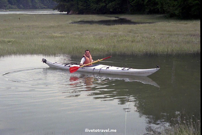
Many years ago, I visited friends who lived in Maine.  She was a high school classmate of mine and we decided one day that she took off work to do something adventurous because -alas- we had delusions of grandeur.  We decided to rent kayaks and do some exploring.  However, the kayak rental place was too busy to take us out so all they could do was rent us kayaks and point us to a place where we could hit a waterway that led to the open sea.  The plan was not to hit the open sea but we would be in saltwater, not a lake or river.

It was a really neat experience though we swapped kayaks halfway through as one of them was quite crappy so we took turns on it.  We had a great time laughing at our clumsiness and learning how to turn and move the kayak.  Columbus had NOTHING on us!

kayak, kayaking, Maine, adventure, outdoors, photo

Yours truly showing how it is done

The fun really started once we packed up to go.  We hoped to tie the kayaks to the truck like the rental place had done; we had had the forethought to pay attention before we first untied the kayaks so we would know how to tie them back up.  Except neither of us really remembered nor knew how to tie a knot… I did multiple knots praying that the more knots, the more secure things would be… My friend was too nervous to drive so I got behind the wheel and drove slowly the short distance we had to go.  All of a sudden we heard a noise and realized the kayaks had shifted.  I came to a quick stop and so did the cars behind me, one of which honked (as if we were in NYC!).  We took a quick look and everything looked like it couldn’t go anywhere though the kayaks had shifted along the roof of the truck.

It was a nerve-wracking drive but, mercifully, without further noise or shifting – the knots did their job!   A Maine adventure for sure!


%d bloggers like this: